Search Constraints
Search Results

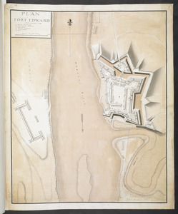
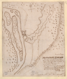
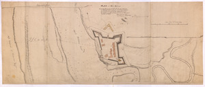
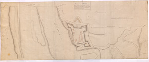
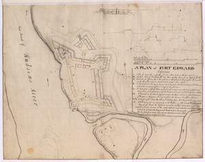
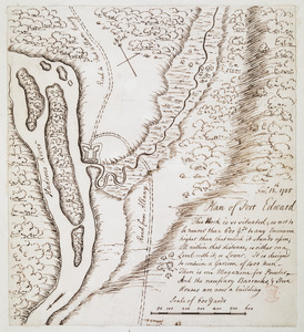
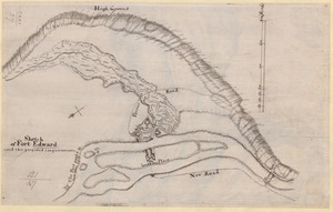
1. Fort Edward


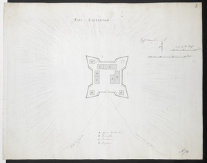
22. 1:st Position

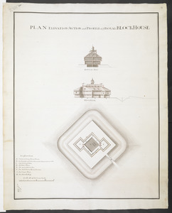
23. 2:d Position


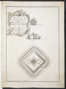
25. 3:d Position

26. 4:th Position
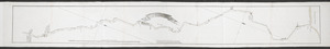
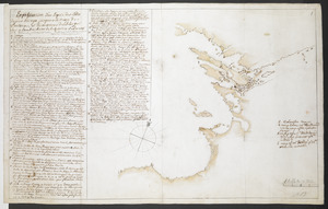
![[A colored map of the route between Albany and Oswego; drawn about 1756, on a scale of 2 miles to an inch]](https://bpldcassets.blob.core.windows.net/derivatives/images/commonwealth:hx11z3223/image_thumbnail_300.jpg)
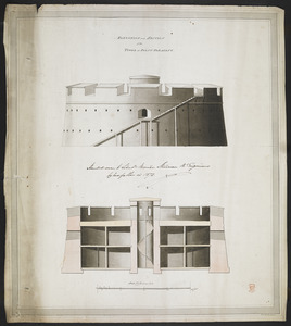
![[A coloured chart of the upper part of Lake Erie at Fort Erie and a detailed plan of Fort Erie, together with three cross sectional drawings]](https://bpldcassets.blob.core.windows.net/derivatives/images/commonwealth:hx11z482r/image_thumbnail_300.jpg)

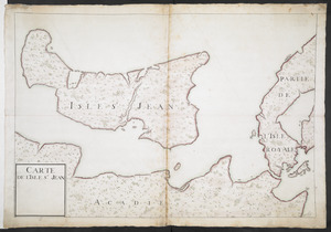
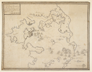
![[A manuscript map of Isle Royalle]](https://bpldcassets.blob.core.windows.net/derivatives/images/commonwealth:hx11z507d/image_thumbnail_300.jpg)
![[A map of Fort Carillon and environs]](https://bpldcassets.blob.core.windows.net/derivatives/images/commonwealth:hx11z538d/image_thumbnail_300.jpg)
![[A map of Fort Carillon and environs]](https://bpldcassets.blob.core.windows.net/derivatives/images/commonwealth:hx11z342k/image_thumbnail_300.jpg)
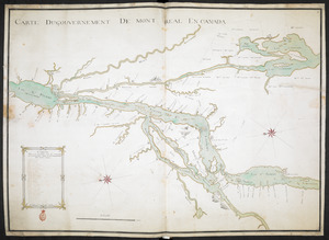
![[A map of Lake Champlain and Lake George, showing the route from Fort Edward to Montreal]](https://bpldcassets.blob.core.windows.net/derivatives/images/commonwealth:hx11z3312/image_thumbnail_300.jpg)
![[A map of Lake Erie with the route southward from Fort Presqu'Isle to Fort Cumberland, with inset plans of Fort Pitt, Fort Venango, Fort Le Boeuf and Fort Presque Isle]](https://bpldcassets.blob.core.windows.net/derivatives/images/commonwealth:6108vw18h/image_thumbnail_300.jpg)
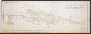
![[A map of Lake George from Fort William Henry to Ticonderoga]](https://bpldcassets.blob.core.windows.net/derivatives/images/commonwealth:hx11z3380/image_thumbnail_300.jpg)
![[A map of Nova Scotia showing the post roads]](https://bpldcassets.blob.core.windows.net/derivatives/images/commonwealth:hx11z494j/image_thumbnail_300.jpg)
![[A map of part of New York, comprehending the country between New York and Quebec, the river Connecticut, &c., to shew "the way from Albany to Canada ..... part by land and part by water;" drawn about 1720, on a scale of 31 miles to an inch]](https://bpldcassets.blob.core.windows.net/derivatives/images/commonwealth:6108vw070/image_thumbnail_300.jpg)
![[A map of part of New York, comprehending the country between New York and Quebec, the river Connecticut, &c., to shew "the way from Albany to Canada ..... part by land and part by water;" drawn about 1720, on a scale of 31 miles to an inch]](https://bpldcassets.blob.core.windows.net/derivatives/images/commonwealth:6108vw09j/image_thumbnail_300.jpg)
![[A map of the east coast of America from Newfoundland to the Bay of Honduras]](https://bpldcassets.blob.core.windows.net/derivatives/images/commonwealth:hx11z584h/image_thumbnail_300.jpg)
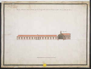
![[A map of the River Schohary with a plan and elevation of the new fort]](https://bpldcassets.blob.core.windows.net/derivatives/images/commonwealth:hx11z356x/image_thumbnail_300.jpg)
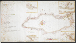
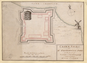
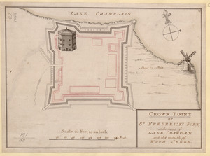
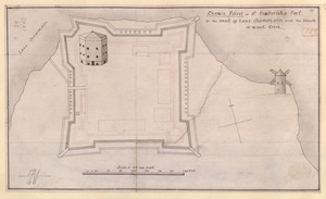
![[A map of the southern part of the Lake Champlain, from "Tienderoga fort" to Crown Point]](https://bpldcassets.blob.core.windows.net/derivatives/images/commonwealth:6108vv78r/image_thumbnail_300.jpg)
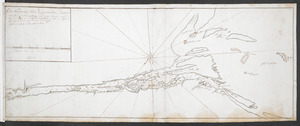
![[A map showing the northern part of Lake George and Fort Ticonderoga]](https://bpldcassets.blob.core.windows.net/derivatives/images/commonwealth:hx11z3444/image_thumbnail_300.jpg)
![[A map showing the post route between the River St. Lawrence and the Bay of Fundy]](https://bpldcassets.blob.core.windows.net/derivatives/images/commonwealth:hx11z4963/image_thumbnail_300.jpg)
![[A map showing the post route between the River St. Lawrence and the Bay of Fundy]](https://bpldcassets.blob.core.windows.net/derivatives/images/commonwealth:hx11z498n/image_thumbnail_300.jpg)
![[A sketch map of the proposed battery (?) on Jekyll Island (?)]](https://bpldcassets.blob.core.windows.net/derivatives/images/commonwealth:hx11z460q/image_thumbnail_300.jpg)
![[Acadie, Isle Saint Jean and part of Isle Royale with the Baye Francoise]](https://bpldcassets.blob.core.windows.net/derivatives/images/commonwealth:hx11z490f/image_thumbnail_300.jpg)
![[Account of the action at Fort Niagara]](https://bpldcassets.blob.core.windows.net/derivatives/images/commonwealth:6108vv66z/image_thumbnail_300.jpg)
![[An outline plan of the harbour and fortifications of Louisbourg]](https://bpldcassets.blob.core.windows.net/derivatives/images/commonwealth:hx11z5128/image_thumbnail_300.jpg)
![[An unfinished chart of the Saint Lawrence River from Perrot Island to the Island of Orleans]](https://bpldcassets.blob.core.windows.net/derivatives/images/commonwealth:hx11z0836/image_thumbnail_300.jpg)


![[Charles Town Harbour & adjacent Islands, Country, Rivers &c]](https://bpldcassets.blob.core.windows.net/derivatives/images/commonwealth:hx11z271t/image_thumbnail_300.jpg)
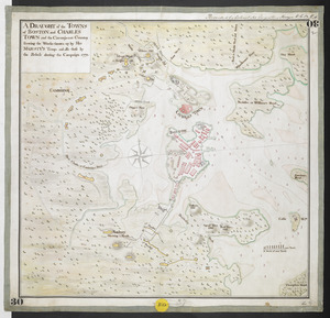
![[Charles Town Neck Exhibiting the Plan of the Town and all the Fortifications in December 1781]](https://bpldcassets.blob.core.windows.net/derivatives/images/commonwealth:hx11z273c/image_thumbnail_300.jpg)

![[Chart of the Saint Lawrence River]](https://bpldcassets.blob.core.windows.net/derivatives/images/commonwealth:hx11z0594/image_thumbnail_300.jpg)
![[Chart of the Saint Lawrence River from Anticosti to Quebec]](https://bpldcassets.blob.core.windows.net/derivatives/images/commonwealth:hx11z079m/image_thumbnail_300.jpg)
![[Coast of South Carolina, Georgia and Florida from Charleston to St. Augustine]](https://bpldcassets.blob.core.windows.net/derivatives/images/commonwealth:hx11z448f/image_thumbnail_300.jpg)
![[Coast of South Carolina, Georgia and Florida from Charleston to St. Augustine]](https://bpldcassets.blob.core.windows.net/derivatives/images/commonwealth:hx11z450g/image_thumbnail_300.jpg)


![[Entrance to the Harbour of S.t Johns Newfoundland]](https://bpldcassets.blob.core.windows.net/derivatives/images/commonwealth:6108vv35z/image_thumbnail_300.jpg)

93. Fort at Carlisle
94. FORT AT IUNIATA
96. Fort Augusta
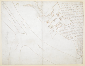
97. FORT BEDFORD
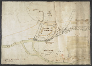
98. FORT BEDFORD
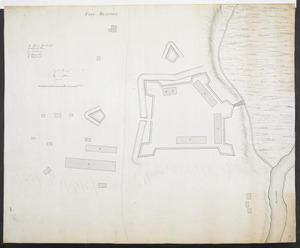
![[Fort Bedford, on the Juniata Creek]](https://bpldcassets.blob.core.windows.net/derivatives/images/commonwealth:hx11z402t/image_thumbnail_300.jpg)