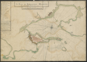
[Acadie, Isle Saint Jean and part of Isle Royale with the Baye Francoise]
![[Acadie, Isle Saint Jean and part of Isle Royale with the Baye Francoise]](https://bpldcassets.blob.core.windows.net/derivatives/images/commonwealth:hx11z490f/image_access_800.jpg)
This map is also available in American Revolutionary Geographies Online (ARGO), a collections portal especially built for material relating to the American Revolutionary War Era. Visit ARGO to learn more about this item and explore the historical geography of North America in the late eighteenth century.
Item Information
- Title:
- [Acadie, Isle Saint Jean and part of Isle Royale with the Baye Francoise]
- Title (alt.):
-
[Nova Scotia, Cape Breton and Prince Edward Island with the Bay of Fundy]
- Description:
-
An untitled map of Nova Scotia, Prince Edward Island and part of Cape Breton Island with the Bay of Fundy by an anonymous French mapmaker. Detail of the New Brunswick coast is also depicted from Ellswort to Richibucto.
- Former owner:
- George, III, King of Great Britain, 1738-1820
- Donor:
- George, IV, King of Great Britain, 1762-1830
- Date:
-
1740–1749
- Format:
-
Maps/Atlases
Manuscripts
- Location:
- British Library
- Collection (local):
-
British Library Collection
- Subjects:
-
United States--History--King George’s War, 1744-1748--Maps, Manuscript--Early works to 1800
Nova Scotia--Maps, Manuscript--Early works to 1800
Acadia--Maps, Manuscript--Early works to 1800
Prince Edward Island--Maps, Manuscript--Early works to 1800
- Places:
-
CanadaNova Scotia (province)
- Extent:
- 1 map : manuscript pen and ink with watercolour ; 20 x 32 cm
- Terms of Use:
-
No known copyright restrictions.
This work is licensed for use under a Creative Commons Attribution Non-Commercial Share Alike License (CC BY-NC-SA).

- Scale:
-
Scale approximately 1:2,135,400
- Language:
-
French
- Catalog Record:
-
http://explore.bl.uk/BLVU1:LSCOP-ALL:BLL01004987893
- Notes:
-
A date of about 1740 to about 1749 is suggested for this map as it does not name Halifax, which was founded by the British in 1749. The map is certainly later than 1710 when Port Royal was captured by the British and renamed Annapolis (as shown on the map). A date in the 1740s seems a possibility on both stylistic grounds and with consideration of the ongoing King George's War (1744 to 1748). The focus on 'Acadie' by the French mapmaker (and the partial mapping of Cape Breton, already held by the French) could suggest that Acadie was under French scrutiny again.
Two scales are given at lower right in "Lieues communes de France de 2282 Toises" and "Lieues Marines de France et d'Angleterre 2853 Toises".
Titled 'Carte dessinée de l'Acadie' in the Catalogue of Maps, Prints, Drawings, etc., forming the geographical and topographical collection attached to the Library of his late Majesty King George the third, etc., London, 1829.
Titled 'A colored map of "Acadie, Isle Royale, Isle St. Jean, and the Baye Françoise, being Nova Scotia, Cape Breton, Pr. Edward's Island, and the Bay of Fundy; drawn by a French hand, on a scale of 13 1/2 French leagues to an inch : 1 f. x 8 in.' in the Catalogue of the manuscript maps, charts, and plans, and of the topographical drawings in the British Museum.

![[An outline plan of the harbour and fortifications of Louisbourg]](https://bpldcassets.blob.core.windows.net/derivatives/images/commonwealth:hx11z5128/image_thumbnail_300.jpg)