[An outline plan of the harbour and fortifications of Louisbourg]
![[An outline plan of the harbour and fortifications of Louisbourg]](https://bpldcassets.blob.core.windows.net/derivatives/images/commonwealth:hx11z5128/image_access_800.jpg)
This map is also available in American Revolutionary Geographies Online (ARGO), a collections portal especially built for material relating to the American Revolutionary War Era. Visit ARGO to learn more about this item and explore the historical geography of North America in the late eighteenth century.
Item Information
- Title:
- [An outline plan of the harbour and fortifications of Louisbourg]
- Cartographer:
- Durell, Philip, -1766
- Former owner:
- George, III, King of Great Britain, 1738-1820
- Donor:
- George, IV, King of Great Britain, 1762-1830
- Contributor:
- Bastide, John Henry, approximately 1700-1770
- Date:
-
1745
- Format:
-
Maps/Atlases
Manuscripts
- Location:
- British Library
- Collection (local):
-
British Library Collection
- Subjects:
-
Austrian Succession, War of, 1740-1748--Maps, Manuscript--Early works to 1800
Military maps--Early works to 1800
United States--History--King George’s War, 1744-1748--Maps, Manuscript--Early works to 1800
Louisbourg (N.S.)--History--Siege, 1745--Maps, Manuscript--Early works to 1800
Louisbourg (N.S.)--Maps, Manuscript--Early works to 1800
- Places:
-
CanadaLouisbourg
- Extent:
- 1 map on 2 sheets : joined, manuscript pen and ink ; 53 x 73 cm
- Terms of Use:
-
No known copyright restrictions.
This work is licensed for use under a Creative Commons Attribution Non-Commercial Share Alike License (CC BY-NC-SA).

- Scale:
-
Scale not given
- Language:
-
English
- Catalog Record:
-
http://explore.bl.uk/BLVU1:LSCOP-ALL:BLL01004987916
- Notes:
-
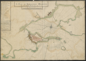
Untitled manuscript map of Louisbourg harbour showing the town and fortifications.
Depicting the same area, on the same scale and on the same paper as the manuscript "Plan of the HARBOUR and FORTIFICATIONS OF LOUISBOURG The harbour Surv'd by Capt. Philip Durell The Town and fortifications by J.H.Bastide Engineer for Nova Scotia", also in the King's Topographical Collection (see Maps K.Top.119.88.2.).
Scale bar at lower right has no data but scale approximately 1:6,300 (data derived from Maps K.Top.119.88.2. - at the same scale).
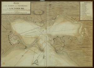
Shows fortifications and batteries.
Lighthouse shown pictorially.
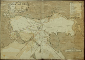
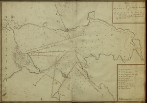
Includes a decorative compass rose in the harbour with emanating rhumb lines.
Includes sounding depths.
Titled 'A drawn Plan of the Harbour and Fortifications of Louisbourg' in the Catalogue of Maps, Prints, Drawings, etc., forming the geographical and topographical collection attached to the Library of his late Majesty King George the third, etc., London, 1829.
Titled 'An outline plan of the harbour and fortifications of Louisbourg; on a scale of 6 1/2 inches to a mile: 2 f. 4 1/2 in. x 1 f. 8 1/2 in' in the Catalogue of the manuscript maps, charts, and plans, and of the topographical drawings in the British Museum.