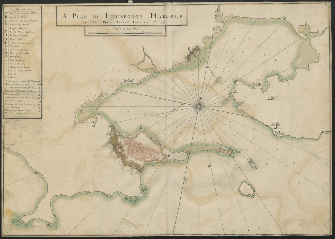
A PLAN OF LOUISBOUGH HARBOUR
This map is also available in American Revolutionary Geographies Online (ARGO), a collections portal especially built for material relating to the American Revolutionary War Era. Visit ARGO to learn more about this item and explore the historical geography of North America in the late eighteenth century.
Item Information
- Title:
- A PLAN OF LOUISBOUGH HARBOUR
- Cartographer:
- Durell, Philip, -1766
- Former owner:
- George, III, King of Great Britain, 1738-1820
- Donor:
- George, IV, King of Great Britain, 1762-1830
- Name on Item:
-
By Capt. Philip Durell. Iune the 17th 1745.
- Date:
-
1745
- Format:
-
Maps/Atlases
Manuscripts
- Location:
- British Library
- Collection (local):
-
British Library Collection
- Subjects:
-
Austrian Succession, War of, 1740-1748--Maps, Manuscript--Early works to 1800
Military maps--Early works to 1800
United States--History--King George’s War, 1744-1748--Maps, Manuscript--Early works to 1800
Louisbourg (N.S.)--History--Siege, 1745--Maps, Manuscript--Early works to 1800
Louisbourg (N.S.)--Maps, Manuscript--Early works to 1800
- Places:
-
CanadaLouisbourg
- Extent:
- 1 map: manuscript pen and ink with watercolour ; 52 x 74 cm
- Terms of Use:
-
No known copyright restrictions.
This work is licensed for use under a Creative Commons Attribution Non-Commercial Share Alike License (CC BY-NC-SA).

- Scale:
-
Scale approximately 1:9,500
- Language:
-
English
- Catalog Record:
-
http://explore.bl.uk/BLVU1:LSCOP-ALL:BLL01004987915
- Notes:
-
The title appears in a surround at the top of the sheet with "A Scale of one Mile" to 6 1/2 inches below.
The Explanation at upper left comprises a lettered (A-N) and symbolic key identifying locations on the map, including the batteries, lighthouse and citadels. The explanation also numbers the guns and mortars.
The map details the English batteries at Louisbourg, Nova Scotia during the War of the Austrian Succession and the siege of Louisbourg.
Titled 'A drawn Plan of Louisbourg Harbour, by Captain Philip Durell, June 17th 1745' in the Catalogue of Maps, Prints, Drawings, etc., forming the geographical and topographical collection attached to the Library of his late Majesty King George the third, etc., London, 1829.
Titled 'A colored "Plan of Louisbough (sic) Harbour, by Captain Philip Durell, June 17th, 1745;" drawn on a scale of 6 1/2 inches to a mile : 2 f. 4 in. x 1 f. 8 1/2 in.' in the Catalogue of the manuscript maps, charts, and plans, and of the topographical drawings in the British Museum.

![[An outline plan of the harbour and fortifications of Louisbourg]](https://bpldcassets.blob.core.windows.net/derivatives/images/commonwealth:hx11z5128/image_thumbnail_300.jpg)