[A map of Lake Champlain and Lake George, showing the route from Fort Edward to Montreal]
![[A map of Lake Champlain and Lake George, showing the route from Fort Edward to Montreal]](https://bpldcassets.blob.core.windows.net/derivatives/images/commonwealth:hx11z3312/image_access_800.jpg)
This map is also available in American Revolutionary Geographies Online (ARGO), a collections portal especially built for material relating to the American Revolutionary War Era. Visit ARGO to learn more about this item and explore the historical geography of North America in the late eighteenth century.
Item Information
- Title:
- [A map of Lake Champlain and Lake George, showing the route from Fort Edward to Montreal]
- Former owner:
- George, III, King of Great Britain, 1738-1820
- Donor:
- George, IV, King of Great Britain, 1762-1830
- Date:
-
1759
- Format:
-
Maps/Atlases
Manuscripts
- Location:
- British Library
- Collection (local):
-
British Library Collection
- Subjects:
-
Champlain, Lake--Maps, Manuscript--Early works to 1800
George, Lake (N.Y. : Lake)--Maps, Manuscript--Early works to 1800
United States--History--French and Indian War, 1754-1763--Maps, Manuscript--Early works to 1800
- Places:
-
George, Lake
Champlain, Lake
- Extent:
- 1 map on 3 sheets : joined and laid on linen, manuscript pen and ink with watercolour ; 22 x 65 cm
- Terms of Use:
-
No known copyright restrictions.
This work is licensed for use under a Creative Commons Attribution Non-Commercial Share Alike License (CC BY-NC-SA).

- Scale:
-
Scale approximately 1:380,160
- Language:
-
English
- Catalog Record:
-
http://explore.bl.uk/BLVU1:LSCOP-ALL:BLL01004987735
- Notes:
-
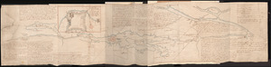
A date of about 1759 is attributed to this map. Previous British Library cataloguing has dated the map between 1758 and 1759. However, the map shows and names a fort at "Crown Point" that was built and named by the British in 1759 (not the French named Fort St. Frederic).
The map shows and names Fort George, built in 1755, on the southern tip of Lake George and it does not show or name Fort William Henry (destroyed in 1757).
Scale given as "Six miles to an Inch" at the lower edge of the map.
Shows the route from Fort Edward to Montreal by water and with a pricked line on the map marking the overland passages.
Arrows with a distinctive feathered fletching indicated the direction of flow in the waterways.
Titled "A drawn Sketch of Lakes Champlain and George" in the Catalogue of Maps, Prints, Drawings, etc., forming the geographical and topographical collection attached to the Library of his late Majesty King George the third, etc., London, 1829.
Titled "A map of Lake Champlain and Lake George, shewing the route from Fort Edward to Montreal; drawn on a scale of 6 miles to an inch: 2 f. 2 in. x 9 in." in the Catalogue of the manuscript maps, charts, and plans, and of the topographical drawings in the British Museum.


![[A map of Fort Carillon and environs]](https://bpldcassets.blob.core.windows.net/derivatives/images/commonwealth:hx11z538d/image_thumbnail_300.jpg)
