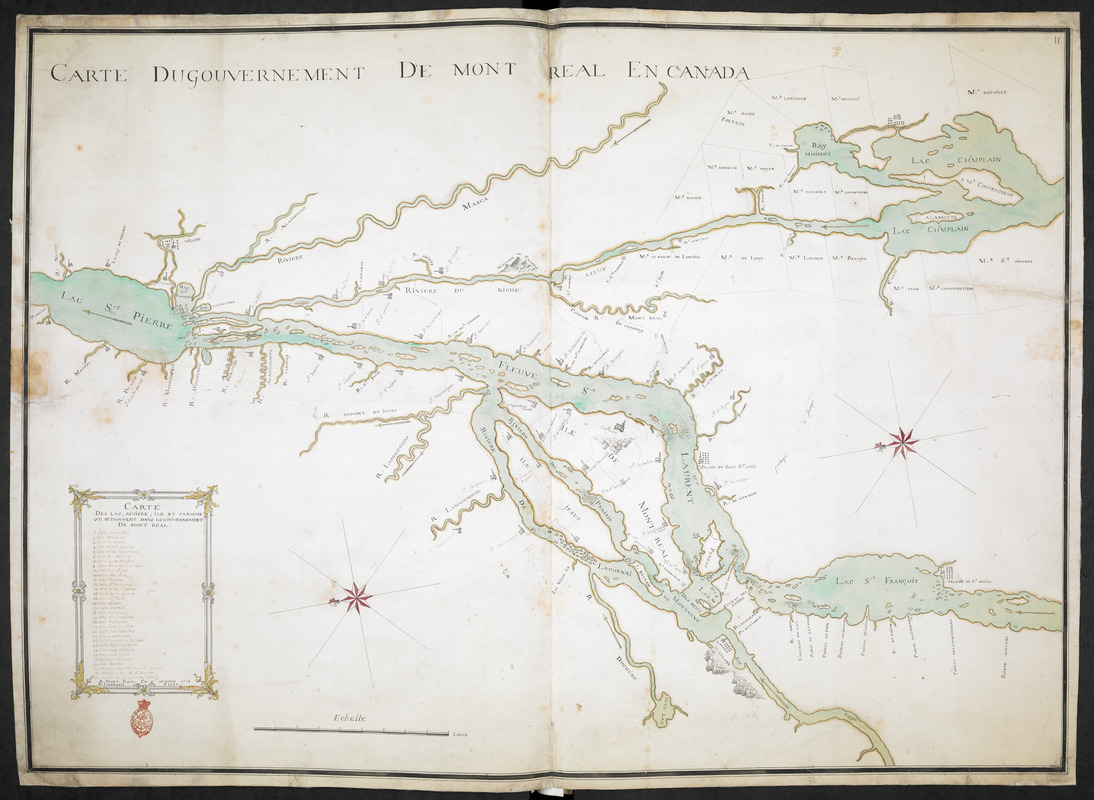
CARTE DU GOUVERNEMENT DE MONT REAL EN CANADA
This map is also available in American Revolutionary Geographies Online (ARGO), a collections portal especially built for material relating to the American Revolutionary War Era. Visit ARGO to learn more about this item and explore the historical geography of North America in the late eighteenth century.
Item Information
- Title:
- CARTE DU GOUVERNEMENT DE MONT REAL EN CANADA
- Cartographer:
- Labrosse, Paul, 1697-1769
- Former owner:
- Amherst, Jeffery Amherst, Baron, 1717-1797
- Former owner:
- Royal United Services Institute for Defence and Security Studies
- Papermaker:
- Dirk and Cornelis Blauw
- Name on Item:
-
A MONT REAL CE 9 OCTOBRE 1760 P. LABROSSE FECIT.
- Date:
-
1760
- Format:
-
Maps/Atlases
- Location:
- British Library
- Collection (local):
-
British Library Collection
- Subjects:
-
Montréal Island (Québec : Island)--Maps, Manuscript--Early works to 1800
- Places:
-
CanadaMontréal, Île de (island)
- Extent:
- 1 map on 2 sheets : joined, laid on linen, manuscript pen and ink with watercolour ; 72 x 102 cm
- Terms of Use:
-
No known copyright restrictions.
This work is licensed for use under a Creative Commons Attribution Non-Commercial Share Alike License (CC BY-NC-SA).

- Publisher:
-
A MONTREAL :
CE 9 OCTOBRE 1760 P. LABROSSE FECIT,
- Scale:
-
Scale approximately 1:180,000
- Language:
-
French
- Catalog Record:
-
http://searcharchives.bl.uk/IAMS_VU2:IAMS040-001999734
- Notes:
-
Relief shown pictorially.
Oriented with north to the left of the map.
Shows title at upper left.
Shows numbered key (1-32) within a decorative surround at lower left, entitled "CARTE DES LAC; RIVIERE, ILE ET PAROISSE QUI SE TROUVENT DANS LE GOUVERNEMENT DE MONT REAL". Within this surround is the signature, "A MONT REAL CE 9 OCTOBRE 1760 P. LABROSSE FECIT".
compare Labrosse's map of Montreal (Add Ms 57,706.3.).
Compare another map by Labrosse - "(Plan de la ville) et faux bourg de Montréal par Paul Labrosse, Sculpteur, 1767". Library and Archives Canada list a photocopy of this map (CARTO2340) with a note that the original manuscript is on permanent display - "L'original de cette carte est exposé en permanence dans la salle John Molson, Compagnie Molson, 1620, rue Notre-Dame, Montréal. Renseignement trouvé le 15 avril 1998."
Shows forts at Chambly, Saint Jean and "Sainneville" (Senneville).
Shows scale of "lieux" at lower centre.
Shows the names of landowners and their plots.
Copy at Add Ms 57,704.11. Bound in R.U.S.I. Vol LXIX. Shows manuscript addition of "11" in pencil at upper right. Laid on archival tissue. Green circular label to verso shows "12". White label to verso showing "DRAWER 27 SECTION 6". Blue label to verso shows "A 27/36". Paper watermarks shows "D & C BLAUW".
- Notes (date):
-
9999


