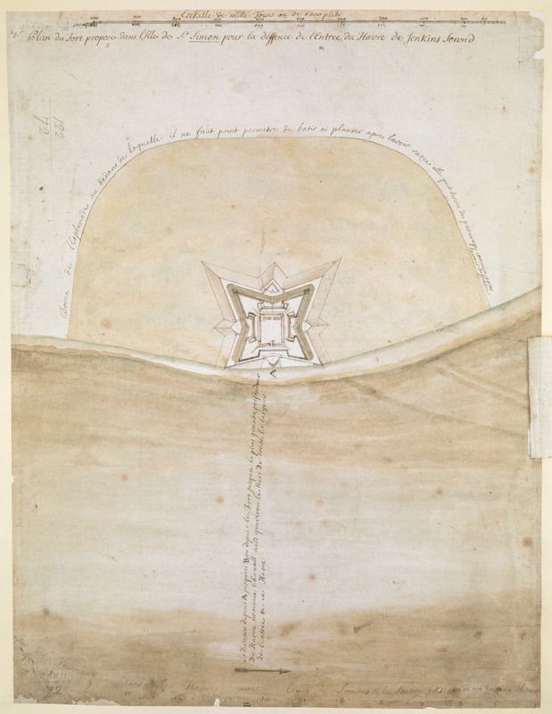
1.r Plan du fort proposé dans l'Ille de S.t Simon pour la deffence de l'Entree du Havre de Jenkins Sownd
This map is also available in American Revolutionary Geographies Online (ARGO), a collections portal especially built for material relating to the American Revolutionary War Era. Visit ARGO to learn more about this item and explore the historical geography of North America in the late eighteenth century.
Item Information
- Title:
- 1.r Plan du fort proposé dans l'Ille de S.t Simon pour la deffence de l'Entree du Havre de Jenkins Sownd
- Cartographer:
- Thomas, John, the Elder
- Former owner:
- George, III, King of Great Britain, 1738-1820
- Donor:
- George, IV, King of Great Britain, 1762-1830
- Date:
-
1738
- Format:
-
Maps/Atlases
Manuscripts
- Location:
- British Library
- Collection (local):
-
British Library Collection
- Subjects:
-
Military art and science--Georgia--Saint Simons Island--Maps, Manuscript--Early works to 1800
Fortification--Georgia--Saint Simons Island--Maps, Manuscript--Early works to 1800
Saint Simons Island (Ga.)--Maps, Manuscript--Early works to 1800
- Places:
-
Glynn (county)Saint Simons Island (island)
- Extent:
- 1 map : manuscript pen and ink with watercolour ; 40 x 32 cm
- Terms of Use:
-
No known copyright restrictions.
This work is licensed for use under a Creative Commons Attribution Non-Commercial Share Alike License (CC BY-NC-SA).

- Scale:
-
Scale approximately 1:7,700
- Language:
-
French
- Catalog Record:
-
http://explore.bl.uk/BLVU1:LSCOP-ALL:BLL01004987600
- Notes:
-
Production details from Cumming (third edition - for Maps K.Top.122.73.) and from a manuscript note in the British Museum catalogue (Maps C.21 bb.3) referencing a letter from Mrs Margaret Davis Cate, 29 July 1955.
With an "Echelle de mille Toises ou de 6000 pieds" across the top of the map.
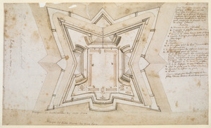
The map shows the fort with pointed defences facing the harbour.
A separate paper overlay on the map offers an alternative proposal for the fort and shows rounded defences facing the harbour.
The overlay includes a note in French that the alteration is " ... pour conserver la Maison de M.r le Lieut.t Vollonnel ..." (to conserve the house of the Lieutenant Colonel).
Compare Maps K.Top.122.74. - an enlarged plan also intended to conserve the Lietenant Colonel's quarters.
Points A (by the fort) B (in the harbour) are marked on the map, indicating the distance between the fort and the deepest point of the harbour.
Shows a boundary line around the fort on land.
Compare Maps K.Top.122.73.
Titled "Plan dessiné du Fort proposé dans l'Isle de St. Simon pour la deffence de l'entrée du Havre de Jenkin's Sound" in the Catalogue of Maps, Prints, Drawings, etc., forming the geographical and topographical collection attached to the Library of his late Majesty King George the third, etc., London, 1829.
Titled "Plan du fort proposé dans l'Isle de St. Simon pour la deffence de l'entrée du Havre de Jenkins sownd;" drawn by a scale of 100 toises to an inch: 1 f. 4 in. x 1 f. in the Catalogue of the manuscript maps, charts, and plans, and of the topographical drawings in the British Museum.
A map of the proposed fort on the southern tip of Saint Simons Island, with the harbour.


![[Map of the proposed fort and adjacent redoubt on Saint Simons Island]](https://bpldcassets.blob.core.windows.net/derivatives/images/commonwealth:hx11z468x/image_thumbnail_300.jpg)