[Coast of South Carolina, Georgia and Florida from Charleston to St. Augustine]
![[Coast of South Carolina, Georgia and Florida from Charleston to St. Augustine]](https://bpldcassets.blob.core.windows.net/derivatives/images/commonwealth:hx11z448f/image_access_800.jpg)
This map is also available in American Revolutionary Geographies Online (ARGO), a collections portal especially built for material relating to the American Revolutionary War Era. Visit ARGO to learn more about this item and explore the historical geography of North America in the late eighteenth century.
Item Information
- Title:
- [Coast of South Carolina, Georgia and Florida from Charleston to St. Augustine]
- Former owner:
- George, III, King of Great Britain, 1738-1820
- Donor:
- George, IV, King of Great Britain, 1762-1830
- Date:
-
[1770?]
- Format:
-
Maps/Atlases
Manuscripts
- Location:
- British Library
- Collection (local):
-
British Library Collection
- Subjects:
-
Coasts--Southern States--Maps, Manuscript--Early works to 1800
South Carolina--Maps, Manuscript--Early works to 1800
Georgia--Maps, Manuscript--Early works to 1800
Florida--Maps, manuscript--Early works to 1800
- Places:
-
Florida
Georgia
South Carolina
- Extent:
- 1 map on 2 sheets : manuscript pen and ink with watercolour ; 139 x 49 cm
- Terms of Use:
-
No known copyright restrictions.
This work is licensed for use under a Creative Commons Attribution Non-Commercial Share Alike License (CC BY-NC-SA).

- Scale:
-
Scale not given
- Language:
-
English
- Catalog Record:
-
http://explore.bl.uk/BLVU1:LSCOP-ALL:BLL01004987588
- Notes:
-
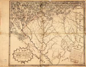
About 1770 date from British Museum manuscript maps catalogue.
Cumming suggests date of production may be earlier than 1770.
Shows "Fort" and "Frederica", north of Jekyll Sound - Fort Frederica was abandoned shortly after the fire of 1758.
A manuscript note in an unidentified hand in the British Museum manuscript maps catalogue (Maps C.21 bb.3) suggests De Brahm as cartographer.
With an ornate but blank title cartouche at upper left.
With blank concentric circles (a compass rose?) in off the coast of "St. Katherine's Sound".
Names "S.t Matthews River" (for St. Johns River) with "Oglethorpe Hill" at its mouth.
Titled "A drawn Map of the Coast of South Carolina and Georgia, from Charlestown to St. Augustine. Two sheets" in the Catalogue of Maps, Prints, Drawings, etc., forming the geographical and topographical collection attached to the Library of his late Majesty King George the third, etc., London, 1829.
Titled "A colored map of the coast of South Carolina, Georgia, and Florida, from Charlestown southward to St. Augustine; drawn about 1770:4 f. 7 in. x 1 f. 8 in." in the Catalogue of the manuscript maps, charts, and plans, and of the topographical drawings in the British Museum.

![[Coast of South Carolina, Georgia and Florida from Charleston to St. Augustine]](https://bpldcassets.blob.core.windows.net/derivatives/images/commonwealth:hx11z450g/image_thumbnail_300.jpg)