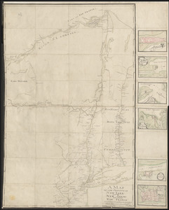
[A map of the southern part of the Lake Champlain, from "Tienderoga fort" to Crown Point]
![[A map of the southern part of the Lake Champlain, from "Tienderoga fort" to Crown Point]](https://bpldcassets.blob.core.windows.net/derivatives/images/commonwealth:6108vv78r/image_access_800.jpg)
This map is also available in American Revolutionary Geographies Online (ARGO), a collections portal especially built for material relating to the American Revolutionary War Era. Visit ARGO to learn more about this item and explore the historical geography of North America in the late eighteenth century.
Item Information
- Title:
- [A map of the southern part of the Lake Champlain, from "Tienderoga fort" to Crown Point]
- Former owner:
- George, III, King of Great Britain, 1738-1820
- Donor:
- George, IV, King of Great Britain, 1762-1830
- Date:
-
1759
- Format:
-
Maps/Atlases
Manuscripts
- Location:
- British Library
- Collection (local):
-
British Library Collection
- Subjects:
-
Champlain, Lake--Maps, Manuscript--Early works to 1800
Fort Ticonderoga (N.Y.)--Maps, Manuscript--Early works to 1800
Crown Point (N.Y.)--Maps, Manuscript--Early works to 1800
- Places:
-
Essex (county)Fort Ticonderoga (transport point)
Champlain, Lake
- Extent:
- 1 map on 8 sheets : joined and laid on linen, manuscript pen and ink with watercolour ; 50 x 179 cm
- Terms of Use:
-
No known copyright restrictions.
This work is licensed for use under a Creative Commons Attribution Non-Commercial Share Alike License (CC BY-NC-SA).

- Scale:
-
Scale approximately 1:14,400
- Language:
-
English
- Catalog Record:
-
http://explore.bl.uk/BLVU1:LSCOP-ALL:BLL01004987780
- Notes:
-
Previous British Library cataloguing has attributed a date of about 1758. The depiction of two forts at Crown Point (one in outline only and drawn with canons) suggests a later date of about 1759 after the destruction of Fort Saint-Frédéric.
Relief is shown by shading.
With a scale of 400 yards to one inch shown along the bottom of the map.
Shows forts.
Shows roads.
With north oriented to the right of the map.
Titled "A drawn Plan of the Southern part of Lake Champlain. Four sheets" in the Catalogue of Maps, Prints, Drawings, etc., forming the geographical and topographical collection attached to the Library of his late Majesty King George the third, etc., London, 1829.
Titled 'A colored plan of the southern part of Lake Champlain, from "Tienderoga fort" to Crown Point; drawn about 1758, on a scale of 400 yards to an inch: 6 f. x 1 f. 8 in." in the Catalogue of the manuscript maps, charts, and plans, and of the topographical drawings in the British Museum.