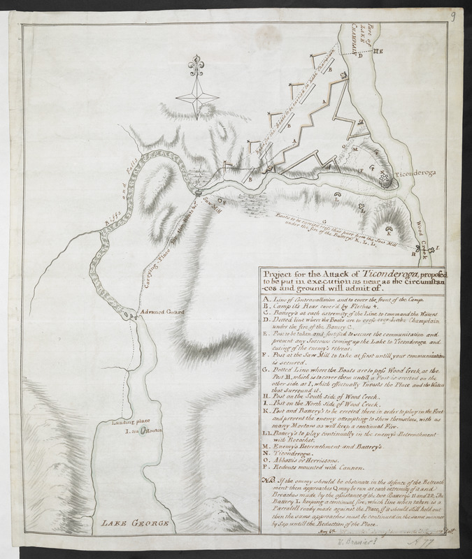
Project for the Attack of Ticonderoga, proposed to be put in executino as near as the circumstances and ground will admit of
This map is also available in American Revolutionary Geographies Online (ARGO), a collections portal especially built for material relating to the American Revolutionary War Era. Visit ARGO to learn more about this item and explore the historical geography of North America in the late eighteenth century.
Item Information
- Title:
- Project for the Attack of Ticonderoga, proposed to be put in executino as near as the circumstances and ground will admit of
- Cartographer:
- Brasier, William
- Former owner:
- Amherst, Jeffery Amherst, Baron, 1717-1797
- Former owner:
- Royal United Services Institute for Defence and Security Studies
- Name on Item:
-
May 6.th W. Brasier Lieutenant to the Ch. Engineer Del.t.
- Date:
-
[1759]
- Format:
-
Maps/Atlases
- Location:
- British Library
- Collection (local):
-
British Library Collection
- Subjects:
-
Fortification--New York (State)--Fort Ticonderoga--Maps, Manuscript--Early works to 1800
Military art and science--New York (State)--Fort Ticonderoga--Maps, Manuscript--Early works to 1800
Lake George (N.Y.)--Maps, Manuscript--Early works to 1800
Champlain, Lake--Maps, Manuscript--Early works to 1800
Fort Ticonderoga (N.Y.)--Maps, Manuscript--Early works to 1800
- Places:
-
Essex (county)Fort Ticonderoga (transport point)
Warren (county)Lake George
Champlain, Lake
- Extent:
- 1 map : manuscript pen and ink with watercolour ; 38 x 31 cm
- Terms of Use:
-
No known copyright restrictions.
This work is licensed for use under a Creative Commons Attribution Non-Commercial Share Alike License (CC BY-NC-SA).

- Publisher:
-
[Lake George] :
May 6.th W. Brasier Lieutenant to the Ch. Engineer Del.t,
- Scale:
-
Scale not given
- Language:
-
English
- Catalog Record:
-
http://searcharchives.bl.uk/IAMS_VU2:IAMS040-001999744
- Notes:
-
Relief shown by shading and by hachuring.
Shows the intended plan of attack by the British at Fort Ticonderoga (the Battle of Fort Ticonderoga took place July 26 and 27, 1759).
Shows the intended landing place near to the "I. au Mouton" (Prison Island).
Shows the overland carrying places, including to the posts on Wood Creek.
Shows the line of fire from batteries intended to cover the carrying of boats overland.
Shows title and lettered key (A-P) in a surround at lower left, includes a textual note regarding alternative plans of attack "If the enemy should be obstinate in the defence of the retrenchment".
Dated and signed at lower left in ink, then partially rubbed out.
Copy at Add Ms 57,712.9. Bound in R.U.S.I. Vol LXXVII. Shows manuscript addition of "9" in pencil at upper right. Shows "A77" in pencil at lower right. Laid on archival tissue. Green circular label to verso shows "76". White label to verso shows "DRAWER 30 SECTION 3". Blue label to verso shows "A 30/16". Paper watermark shows a horn within a shield.
- Notes (date):
-
9999
This date is inferred.

![[Map of Fort Carillon]](https://bpldcassets.blob.core.windows.net/derivatives/images/commonwealth:hx11z179t/image_thumbnail_300.jpg)
![[PLAN de Carillon]](https://bpldcassets.blob.core.windows.net/derivatives/images/commonwealth:hx11z1778/image_thumbnail_300.jpg)