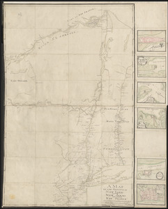
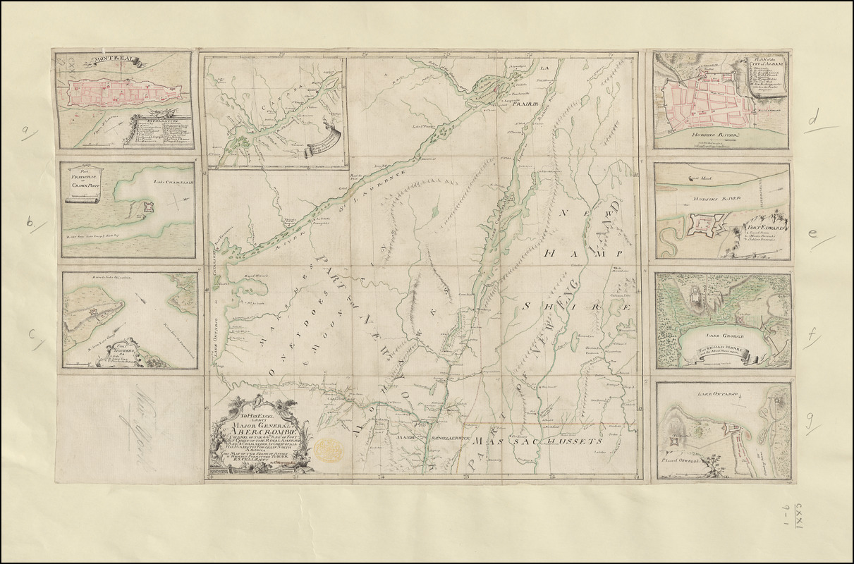
TO HIS EXCELLENCY MAJOR GENERAL ABERCROMBIE COLONEL OF THE 44TH REG:T OF FOOT CO: IN CHIEF OF THE ROYAL AMERICAN REG: & COMMANDER IN CHIEF OF ALL HIS MAJESTYS FORCES IN NORTH AMERICA THIS MAP OF THE SCENE OF ACTION IS HUMBLY SUBMITTED TO YOUR EXCELLENCY
This map is also available in American Revolutionary Geographies Online (ARGO), a collections portal especially built for material relating to the American Revolutionary War Era. Visit ARGO to learn more about this item and explore the historical geography of North America in the late eighteenth century.
Item Information
- Title:
- TO HIS EXCELLENCY MAJOR GENERAL ABERCROMBIE COLONEL OF THE 44TH REG:T OF FOOT CO: IN CHIEF OF THE ROYAL AMERICAN REG: & COMMANDER IN CHIEF OF ALL HIS MAJESTYS FORCES IN NORTH AMERICA THIS MAP OF THE SCENE OF ACTION IS HUMBLY SUBMITTED TO YOUR EXCELLENCY
- Cartographer:
- Abercrombie, Thomas
- Former owner:
- George, III, King of Great Britain, 1738-1820
- Donor:
- George, IV, King of Great Britain, 1762-1830
- Dedicatee:
- Abercromby, James, 1706-1781
- Name on Item:
-
By T.ˢ Abercrombie Capt.
- Date:
-
1757–1759
- Format:
-
Maps/Atlases
Manuscripts
- Location:
- British Library
- Collection (local):
-
British Library Collection
- Subjects:
-
Fortification--New York (State)--Maps, manuscript--Early works to 1800
New York (State)--Maps, Manuscript--Early works to 1800
United States--History--French and Indian War, 1754-1763--Maps, Manuscript--Early works to 1800
Montréal (Québec)--Maps, Manuscript--Early works to 1800
Fort Albany (N.Y.)--Maps, Manuscript--Early works to 1800
Fort Ticonderoga (N.Y.)--Maps, Manuscript--Early works to 1800
Albany (N.Y.)--Maps, Manuscript--Early works to 1800
Fort Edward (N.Y.)--Maps, Manuscript--Early works to 1800
Fort William Henry (N.Y.)--Maps, Manuscript--Early works to 1800
Fort Oswego (Oswego, N.Y.)--Maps, Manuscript--Early works to 1800
- Places:
-
Oswego (county)Fort Oswego
Washington (county)Fort Edward
Albany (county)Albany
CanadaMontreal
Warren (county)Fort William Henry (area)
Essex (county)Fort Ticonderoga (transport point)
Fort Frederick (historical)
- Extent:
- 9 maps on 1 sheet : dissected into 20 pieces and laid on a supporting sheet of paper, manuscript pen and ink with watercolour ; map 30 x 30 cm, sheet 31 x 52 cm
- Terms of Use:
-
No known copyright restrictions.
This work is licensed for use under a Creative Commons Attribution Non-Commercial Share Alike License (CC BY-NC-SA).

- Scale:
-
Scale approximately 1:1,350,000
- Language:
-
English
- Catalog Record:
-
http://explore.bl.uk/BLVU1:LSCOP-ALL:BLL01004987791
- Notes:
-
Relief is shown pictorially.
No scale is given on the map (scale determined from degrees of latitude).
Shows forts.
The dedicatory title appears in a decorative surround at lower left.
The name "T.ˢ Abercrombie Capt." is in a different ink to the rest of the title and map.
With an inset map at upper left showing the "Continuation of the River St Laurence to Quebec" at a scale of 1:2,000,000.
Seven additional plans of forts and towns within the region are set around the central map.
Includes a map of "Montreal" with a scale of 200 feet (?) to 3/4 inch (1:3200). The map measures 7 x 10 cm. With a numbered key (1-20) identifying places of note within the town.
Includes a map of "Fort FREDERIC or CROWN POINT" with a scale of 600 feet to 3/4 inch (1:9600).
Includes a map of "FORT TICONDEROGA" with a scale of 200 yards to 5/8 inch (1:4500).
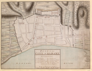
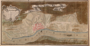
Includes a "PLAN of the CITY of ALBANY" with a lettered key (A-H) identifying locations within the town. The map is drawn at a scale of 1000 feet to an inch (1:12,000).
Includes a map of "FORT EDWARD" with a numbered key (1-3) identifying the barracks and guard room. With a scale of 600 feet to 1 1/4 inches (1:5760).
Includes a map of "Fort WILLIAM HENRY and the Attack there upon" with a scale of 300 yards to 1/2 inch (121,600).
Includes a "Plan of OSWEGO &C" with a scale of 1000 yards to 9/16 inch (1:64,000).
The map bears similarties with Francis Pfister's manuscript maps of the province of New York (Maps K.Top.121.2.), and a further copy without the plans (Maps K.Top.121.1.).
The town plans are listed separately in the Catalogue of the manuscript maps, charts, and plans, and of the topographical drawings in the British Museum.
There is some uncertainty (see Ross, John F. War on the Run: The Epic Story of Robert Rogers and the Conquest of America, page 468) about Captain Thomas Abercrombie (see Tooley's Dictionary of Mapmakers A-D - perhaps attributing some maps to Thomas that were drawn by James?) and Captain James Abercrombie, aide-de-camp to his uncle General James Abercromby (see the Dictionary of Canadian Biography). However, this map is clearly signed "T.ˢ Abercrombie".
Titled "A drawn Map of part of the State of New York, by Capt. T. Abercrombie" in the Catalogue of Maps, Prints, Drawings, etc., forming the geographical and topographical collection attached to the Library of his late Majesty King George the third, etc., London, 1829.
Titled 'A colored "map of the Scene of Action" [in 1758]: being that part of the state of New York situated between Lake Ontario and Massachusetts, northward to the St. Lawrence; drawn by Capt. Thos. Abercrombie, and dedicated to M.- General Abercrombie: 1 f. x 1 f. in the Catalogue of the manuscript maps, charts, and plans, and of the topographical drawings in the British Museum.
Lake Champlain and Lake Saint George form the central focus of the map. Detail extends from Montreal in the north to Coeymans in the south, and from Lake Winnipesaukee in the east to Oswego in the west.