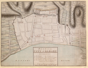
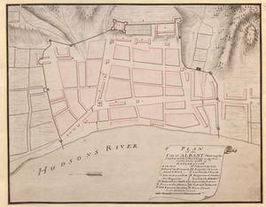
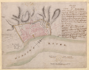
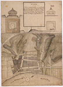
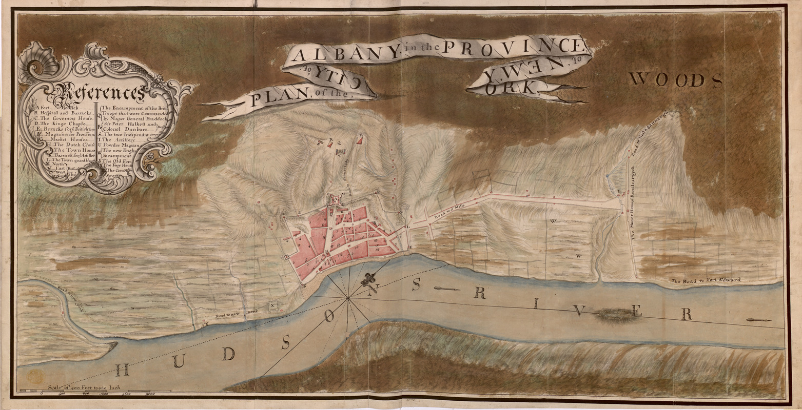
PLAN, of the CITY, of ALBANY, in the PROVINCE, of, NEW, YORK
This map is also available in American Revolutionary Geographies Online (ARGO), a collections portal especially built for material relating to the American Revolutionary War Era. Visit ARGO to learn more about this item and explore the historical geography of North America in the late eighteenth century.
Item Information
- Title:
- PLAN, of the CITY, of ALBANY, in the PROVINCE, of, NEW, YORK
- Cartographer:
- Sowers, Thomas
- Former owner:
- George, III, King of Great Britain, 1738-1820
- Donor:
- George, IV, King of Great Britain, 1762-1830
- Name on Item:
-
Tho.s Sowers Eng.r 1756.
- Date:
-
1756
- Format:
-
Maps/Atlases
Manuscripts
- Location:
- British Library
- Collection (local):
-
British Library Collection
- Subjects:
-
Fortification--New York (State)--Albany--Maps, Manuscript--Early works to 1800
Military art and science--New York (State)--Albany--Maps, Manuscript--Early works to 1800
Albany (N.Y.)--Maps, Manuscript--Early works to 1800
Fort Albany (N.Y.)--Maps, Manuscript--Early works to 1800
United States--History--French and Indian War, 1754-1763--Maps, Manuscript--Early works to 1800
- Places:
-
Albany (county)Albany
Fort Frederick (historical)
- Extent:
- 1 map on 2 sheets : joined, manuscript pen and ink with watercolour ; 44 x 89 cm
- Terms of Use:
-
No known copyright restrictions.
This work is licensed for use under a Creative Commons Attribution Non-Commercial Share Alike License (CC BY-NC-SA).

- Scale:
-
Scale approximately 1:4,800
- Language:
-
English
- Catalog Record:
-
http://explore.bl.uk/BLVU1:LSCOP-ALL:BLL01004987676
- Notes:
-
Relief is shown by shading.
With a "Scale of 400 Feet to an inch" at lower left.
The title is given on a central banner with some of the text reversed - to appear as if it is being read "through" the banner.
With an extensive list of references (A to Z) within a decorative cartouche at upper left identifying locations of note within the town.
Shows the position of the troops of "Major General Braddock", "Sir Peter Halkett" and "Colonel Dunbars".
Shows and names Fort Frederick.
Shows roads to New York, Fort Edward and "Nestagaunaugh".
Shows the "Maner House of Renslearwyck" (Manor of Rensselaerswyck, Manor Rensselaerswyck, Van Rensselaer Manor, or Rensselaerswyck).
With a compass in the Hudson River orienting north to the top of the map.
Titled "A drawn Plan of the City of Albany, by Thos. Sowers, Eng.r 1756" in the Catalogue of Maps, Prints, Drawings, etc., forming the geographical and topographical collection attached to the Library of his late Majesty King George the third, etc., London, 1829.
Titled 'A colored "plan of the city of Albany;" shewing designs for fortifications, the encampments of the British troops under M.-General Braddock, Sir Peter Halkett and Col. Dunbar; drawn by Thos. Sowers, engr., 1756, on a scale of 400 feet to an inch: 3 f. x 1 f. 6 in.' in the Catalogue of the manuscript maps, charts, and plans, and of the topographical drawings in the British Museum.