[A manuscript map of Isle Royalle]
![[A manuscript map of Isle Royalle]](https://bpldcassets.blob.core.windows.net/derivatives/images/commonwealth:hx11z507d/image_access_800.jpg)
This map is also available in American Revolutionary Geographies Online (ARGO), a collections portal especially built for material relating to the American Revolutionary War Era. Visit ARGO to learn more about this item and explore the historical geography of North America in the late eighteenth century.
Item Information
- Title:
- [A manuscript map of Isle Royalle]
- Cartographer:
- Dixon, Matthew, (Cartographer)
- Former owner:
- George, III, King of Great Britain, 1738-1820
- Donor:
- George, IV, King of Great Britain, 1762-1830
- Date:
-
1740–1758
- Format:
-
Maps/Atlases
Manuscripts
- Location:
- British Library
- Collection (local):
-
British Library Collection
- Subjects:
-
Cape Breton Island (N.S.)--Maps, Manuscript--Early works to 1800
- Places:
-
CanadaCape Breton Island (island)
- Extent:
- 1 map : manuscript pen and ink with watercolour ; 57 x 46 cm
- Terms of Use:
-
No known copyright restrictions.
This work is licensed for use under a Creative Commons Attribution Non-Commercial Share Alike License (CC BY-NC-SA).

- Scale:
-
Scale approximately 1:374,000
- Language:
-
English
- Catalog Record:
-
http://explore.bl.uk/BLVU1:LSCOP-ALL:BLL01004987913
- Notes:
-
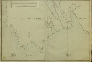
A manuscript addition to the map's verso reads "Cape Breton from Mr Dixon".
Compare "A plan and section of the old wharf, with ye design of a new dock for the navy at Annapolis Royal in Nova Scotia 1756. Mattw: Dixon, engineer" listed in The Library of Congress Online Catalog (CALL NUMBER: G3424.A45P55 1756 .D5 Vault) within the Peter Force map collection, which is also referenced in 'Tooley's Dictionary of Mapmakers A-D'.
Estimated date from previous cataloguing.
Includes the eastern part of Nova Scotia, naming Cape Canso.
Degrees of latitude are given outside the neatline in the right margin.
The scale is given at lower right where the "SCALE of SIX LEAGUES" is equal to 3 1/2 inches.
A large and decorative compass rose is shown in the Atlantic orienting north to the top of the page.
Titled 'Carte dessinée de l'Isle Royalle' in the Catalogue of Maps, Prints, Drawings, etc., forming the geographical and topographical collection attached to the Library of his late Majesty King George the third, etc., London, 1829.
Titled 'A colored map of the "Isle Royale," or Cape Breton; drawn on a scale of 1 2/3 league to an inch : 1 f. 8 in. x 1 f. 6 in." in the Catalogue of the manuscript maps, charts, and plans, and of the topographical drawings in the British Museum.