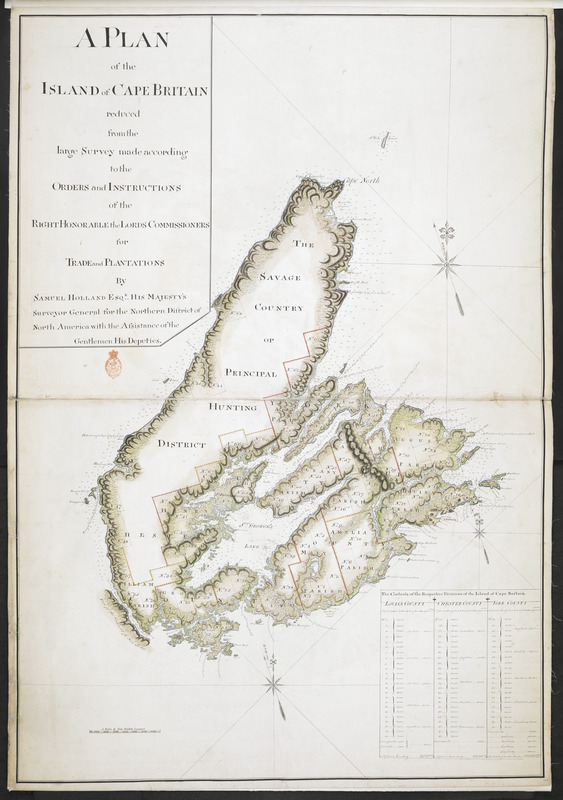
A PLAN of the ISLAND of CAPE BRITAIN reduced from the large Survey made according to the ORDERS and INSTRUCTIONS of the RIGHT HONORABLE the LORDS COMMISSIONERS for TRADE and PLANTATIONS
This map is also available in American Revolutionary Geographies Online (ARGO), a collections portal especially built for material relating to the American Revolutionary War Era. Visit ARGO to learn more about this item and explore the historical geography of North America in the late eighteenth century.
Item Information
- Title:
- A PLAN of the ISLAND of CAPE BRITAIN reduced from the large Survey made according to the ORDERS and INSTRUCTIONS of the RIGHT HONORABLE the LORDS COMMISSIONERS for TRADE and PLANTATIONS
- Surveyor:
- Holland, Samuel, 1728-1801
- Cartographer:
- Wright, Thomas, surveyor general
- Former owner:
- Amherst, Jeffery Amherst, Baron, 1717-1797
- Former owner:
- Royal United Services Institute for Defence and Security Studies
- Name on Item:
-
By SAMUEL HOLLAND ESQ.R HIS MAJESTY'S Surveyor General for the Northern District of North America with the Assistance of the Gentlemen His Deputies.
- Date:
-
[ca. 1767]
- Format:
-
Maps/Atlases
- Location:
- British Library
- Collection (local):
-
British Library Collection
- Subjects:
-
Cape Breton Island (N.S.)--Maps, Manuscript--Early works to 1800
- Places:
-
CanadaCape Breton Island (island)
- Extent:
- 1 map : manuscript pen and ink with watercolour ; 103 x 71 cm
- Terms of Use:
-
No known copyright restrictions.
This work is licensed for use under a Creative Commons Attribution Non-Commercial Share Alike License (CC BY-NC-SA).

- Publisher:
-
[Place of production not identified] :
[producer not identified]
- Scale:
-
Scale approximately 1:365,000
- Language:
-
English
- Catalog Record:
-
http://searcharchives.bl.uk/IAMS_VU2:IAMS040-001999731
- Notes:
-
Relief shown by shading.
Sounding depths are given.
Compare "A plan of the island of Cape Britain reduced from the large survey made by the orders and instructions of the right honorable the Lords Commissioners for Trade and Plantations by Samuel Holland esqr. surveyor general of the northern district of America &c. with the assistance of his deputies" (Maps 3-C-13 in the Gage Papers at the William L. Clements Library) dated 19th April 1767 and signed at lower right "By Ensign George Sproule of the 59th Regt. deputy surveyor".
Compare "Cape Breton Island" (265 Ah1) and "Cape Britain Island" (267 Ah1) listed by Hornsby (in Surveyors of Empire) at the UK Hydrographic Office Taunton (both since transferred to The National Archives, Kew - now ADM 352/155 and ADM 352/156 respectively).
Shows title at upper left.
Shows "A Scale of Five Statute Leagues" at lower left.
Shows "THE SAVAGE COUNTRY or PRINCIPAL HUNTING DISTRICT" as well as county borders and acreages.
Shows English and French toponyms.
Shows table at lower right entitled "The Contents of the Respective Divisions of the Island of Cape Britain".
Copy at Add Ms 57,701.7. Bound in R.U.S.I. Vol LXVI. Shows red stamp of R.U.S.I. beneath title cartouche at upper left. Manuscript addition of "7" in pencil at lower right. Laid on linen. Green circular sticker to verso with "5". Additional white label to verso showing "DRAWER 27 SECTION 5". Additional blue label to verso showing "a 27/5".
- Notes (date):
-
9999

![[A manuscript map of Isle Royalle]](https://bpldcassets.blob.core.windows.net/derivatives/images/commonwealth:hx11z507d/image_thumbnail_300.jpg)