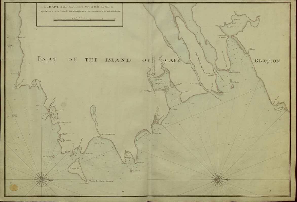
A CHART of the South East Part of l'Isle Royal, or Cape Bretton taken from the best Surveys, and the Observations of the most able Pilots
This map is also available in American Revolutionary Geographies Online (ARGO), a collections portal especially built for material relating to the American Revolutionary War Era. Visit ARGO to learn more about this item and explore the historical geography of North America in the late eighteenth century.
Item Information
- Title:
- A CHART of the South East Part of l'Isle Royal, or Cape Bretton taken from the best Surveys, and the Observations of the most able Pilots
- Former owner:
- George, III, King of Great Britain, 1738-1820
- Donor:
- George, IV, King of Great Britain, 1762-1830
- Date:
-
[1740?–1758?]
- Format:
-
Maps/Atlases
Manuscripts
- Location:
- British Library
- Collection (local):
-
British Library Collection
- Subjects:
-
Cape Breton Island (N.S.)--Maps, Manuscript--Early works to 1800
- Places:
-
CanadaCape Breton Island (island)
- Extent:
- 1 map : manuscript pen and ink with watercolour ; 51 x 74 cm
- Terms of Use:
-
No known copyright restrictions.
This work is licensed for use under a Creative Commons Attribution Non-Commercial Share Alike License (CC BY-NC-SA).

- Scale:
-
Scale approximately 1:152,000
- Language:
-
English
- Catalog Record:
-
http://explore.bl.uk/BLVU1:LSCOP-ALL:BLL01004987914
- Notes:
-
1740 date attributed from previous cataloguing.
The map names the lighthouse at Louisbourg, suggesting a date of before 1758 when the lighthouse was damaged during the Final Siege of Louisbourg.
The title appears in a surround at upper left with "A Scale of Leagues" below.
Two decorative compass roses in the Atlantic Ocean show emanating rhumb lines and orient north to the right of the page.
Shows sounding depths.
Includes "Spanish Harbour" and "St Anne Harbour or Port Dauphin" with "St Anne's Town or Battery".
Geographic detail extends from "Fouchett" in the south to "Niganiche Town and Island" in the north.
Titled 'A drawn Chart of the South-East part of l'Isle Royal or Cape Breton' in the Catalogue of Maps, Prints, Drawings, etc., forming the geographical and topographical collection attached to the Library of his late Majesty King George the third, etc., London, 1829.
Titled 'A "Chart of the South-East part of l'Isle Royal, or Cape Bretton;" drawn on a scale of 1 1/4 inch to a league. 2 f. 5 in. x 1 f. 8 in.' in the Catalogue of the manuscript maps, charts, and plans, and of the topographical drawings in the British Museum.

![[A manuscript map of Isle Royalle]](https://bpldcassets.blob.core.windows.net/derivatives/images/commonwealth:hx11z507d/image_thumbnail_300.jpg)