[A map showing the post route between the River St. Lawrence and the Bay of Fundy] : [on a scale of 5 1/3 miles to an inch.]
![[A map showing the post route between the River St. Lawrence and the Bay of Fundy]](https://bpldcassets.blob.core.windows.net/derivatives/images/commonwealth:hx11z4963/image_access_800.jpg)
This map is also available in American Revolutionary Geographies Online (ARGO), a collections portal especially built for material relating to the American Revolutionary War Era. Visit ARGO to learn more about this item and explore the historical geography of North America in the late eighteenth century.
Item Information
- Title:
- [A map showing the post route between the River St. Lawrence and the Bay of Fundy] : [on a scale of 5 1/3 miles to an inch.]
- Description:
-
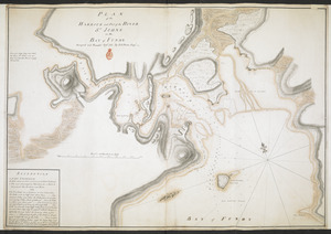
A manuscript map showing the post route from the River St Lawrence to the Bay of Fundy by James Peachey, to accompany the deputy Postmaster General's report
- Cartographer:
- Peachey, James, -1797
- Former owner:
- George, III, King of Great Britain, 1738-1820
- Donor:
- George, IV, King of Great Britain, 1762-1830
- Contributor:
- Finlay, Hugh, 1732-1801
- Addressee:
- Dorchester, Guy Carleton, Baron, 1724-1808
- Contributor:
- Parr, John, 1725-1791
- Contributor:
- Haldimand, Frederick, Sir, 1718-1791
- Date:
-
1784–1787
- Format:
-
Maps/Atlases
Manuscripts
- Location:
- British Library
- Collection (local):
-
British Library Collection
- Subjects:
-
Postal service--Nova Scotia--Maps, Manuscript--Early works to 1800
Saint John River (Me. and N.B.)--Maps, Manuscript--Early works to 1800
- Places:
-
MaineSaint John River
CanadaNova Scotia (province)
- Extent:
- 1 map on 2 sheets : joined, manuscript pen and ink with watercolour ; 53 x 123 cm
- Terms of Use:
-
No known copyright restrictions.
This work is licensed for use under a Creative Commons Attribution Non-Commercial Share Alike License (CC BY-NC-SA).

- Scale:
-
Scale 1:337,700
- Language:
-
English
- Catalog Record:
-
http://explore.bl.uk/BLVU1:LSCOP-ALL:BLL01004987878
- Notes:
-
Place of production and date from Hugh Finlay's accompanying report (see Maps K.Top.119.59.2.a.) and previous British Library cataloguing. Previously dated 1784, the year in which Sir Frederick Haldimand, Governor of the Province of Québec and responsible for ordering the map's production, according to the report, departed on leave for England. He did not return (although, conceivably, he could have ordered the map from England). 1787 is the date on the report.
James Peachey's name is shown at the lower edge of the map, above which is the scale of 5 1/3 miles to an inch.
The map extends from the River St Lawrence at Rivière-de-Loup southwards via Lac Tèmiscouata, the River Madawaska and the River St John to the Bay of Fundy. Fourteen post houses are depicted and numbered along this route with a further three at the north end without numbers.
Textual annotations describe good land, indicate bridges, comment on navigability and comment "by the information of the Indians".
This map is accompanied by a manscript copy of a report by Hugh Finlay, Deputy Postmaster General, to Lord Dorchester, Governor General of Quebec, Nova Scotia, and New Brunswick. Two hands are discernible in the report; the author and the second, who makes notes on the early pages including that "a Sketch of this route made by order of Sir Frederick Haldimand should accompany this Report, together with a Sketch of the Road from Annapolis to Halifax made by order of Governor Parr". The report comprises 32 two pages with two additional tables of distance in British miles bound in.
Titled 'A drawn Map of the Post Route between the River St.Lawrence and the Bay of Fundy, by ditto. Two sheets' with the report titled 'A MS. copy of a Report made by Hugh Finlay, the deputy Postmaster General for the Province of Quebec, to Lord Dorchester, Governor-General of the Provinces of Quebec, Nova Scotia, and New Brunswick, after a Survey of the Post Route between Quebec and Halifax, 1787' (and where ditto was 'A drawn Map of Nova Scotia, by James Peachey. Two sheets' in the British Museum, Catalogue of Maps, Prints, Drawings, etc., forming the geographical and topographical collection attached to the Library of his late Majesty King George the third, etc., London, 1829.
Titled 'A colored Map of the Post Route between the River St. Lawrence and the Bay of Fundy; drawn by James Peachey, engineer, 60th regiment, on a scale of 5 1/2 miles to an inch : 4 f. x 1 f. 9 in.' in the Catalogue of the manuscript maps, charts, and plans, and of the topographical drawings in the British Museum.

![[A map showing the post route between the River St. Lawrence and the Bay of Fundy]](https://bpldcassets.blob.core.windows.net/derivatives/images/commonwealth:hx11z498n/image_thumbnail_300.jpg)
![[A map of Nova Scotia showing the post roads]](https://bpldcassets.blob.core.windows.net/derivatives/images/commonwealth:hx11z494j/image_thumbnail_300.jpg)

