[A map of Nova Scotia showing the post roads]
![[A map of Nova Scotia showing the post roads]](https://bpldcassets.blob.core.windows.net/derivatives/images/commonwealth:hx11z494j/image_access_800.jpg)
This map is also available in American Revolutionary Geographies Online (ARGO), a collections portal especially built for material relating to the American Revolutionary War Era. Visit ARGO to learn more about this item and explore the historical geography of North America in the late eighteenth century.
Item Information
- Title:
- [A map of Nova Scotia showing the post roads]
- Description:
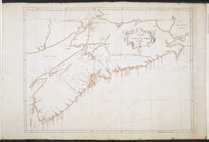
-
A manuscript map of Nova Scotia showing the post routes by James Peachey produced to accompany the Deputy Postmaster General's report.
- Cartographer:
- Peachey, James, -1797
- Former owner:
- George, III, King of Great Britain, 1738-1820
- Donor:
- George, IV, King of Great Britain, 1762-1830
- Contributor:
- Finlay, Hugh, 1732-1801
- Addressee:
- Dorchester, Guy Carleton, Baron, 1724-1808
- Contributor:
- Parr, John, 1725-1791
- Contributor:
- Haldimand, Frederick, Sir, 1718-1791
- Date:
-
1787
- Format:
-
Maps/Atlases
Manuscripts
- Location:
- British Library
- Collection (local):
-
British Library Collection
- Subjects:
-
Postal service--Nova Scotia--Maps, Manuscript--Early works to 1800
Nova Scotia--Maps, Manuscript--Early works to 1800
- Places:
-
CanadaNova Scotia (province)
- Extent:
- 1 map on 2 sheets : joined, manuscript pen and ink with watercolour ; 42 x 95 cm
- Terms of Use:
-
No known copyright restrictions.
This work is licensed for use under a Creative Commons Attribution Non-Commercial Share Alike License (CC BY-NC-SA).

- Scale:
-
Scale 1:506,880
- Language:
-
English
- Catalog Record:
-
http://explore.bl.uk/BLVU1:LSCOP-ALL:BLL01004987899
- Notes:
-
Place of production and date from Hugh Finlay's accompanying report (see Maps K.Top.119.59.2.a.).
The map delineates and names counties within Nova Scotia.
The scale at upper right is given as "8 Miles in an Inch".
A note at upper right lists the post houses; "Joseph Peters, Halifax 44 miles to George Deschamps at Windsor", "John Fowler, Horton 17 Miles", "Robert Tucker, Annapolis 72 Miles", "W McDonald, Digby 15 Miles", "From Digby to St. John's, NEW BRUNSWICK 12 Leagues across the Bay of Fundy".
Shows post routes and the "Road markt out by Govn. Parr's Orders in 1784".
This map is intended to accompany by a manscript copy of a report by Hugh Finlay, Deputy Postmaster General, to Lord Dorchester, Governor General of Quebec, Nova Scotia, and New Brunswick (see Maps K.Top.119.59.2.a.).
Titled 'A drawn Map of Nova Scotia, by James Peachey. Two sheets' with the report titled 'A MS. copy of a Report made by Hugh Finlay, the deputy Postmaster General for the Province of Quebec, to Lord Dorchester, Governor-General of the Provinces of Quebec, Nova Scotia, and New Brunswick, after a Survey of the Post Route between Quebec and Halifax, 1787' in the British Museum, Catalogue of Maps, Prints, Drawings, etc., forming the geographical and topographical collection attached to the Library of his late Majesty King George the third, etc., London, 1829.
Titled 'A colored map of Nova Scotia, shewing the Post routes; drawn about 1785, by James Peachey, Ensign, 60th regt., on a scale of 8 miles to an inch : 3 f. x 1 f. 3 in. This is accompanied by a report made by Hugh Finlay, deputy-postmaster-general, to Lord Dorchester, Governor-general of Quebec, Nova Scotia, and New Brunswick' in the Catalogue of the manuscript maps, charts, and plans, and of the topographical drawings in the British Museum.

![[A map showing the post route between the River St. Lawrence and the Bay of Fundy]](https://bpldcassets.blob.core.windows.net/derivatives/images/commonwealth:hx11z4963/image_thumbnail_300.jpg)
![[A map showing the post route between the River St. Lawrence and the Bay of Fundy]](https://bpldcassets.blob.core.windows.net/derivatives/images/commonwealth:hx11z498n/image_thumbnail_300.jpg)
![[Acadie, Isle Saint Jean and part of Isle Royale with the Baye Francoise]](https://bpldcassets.blob.core.windows.net/derivatives/images/commonwealth:hx11z490f/image_thumbnail_300.jpg)