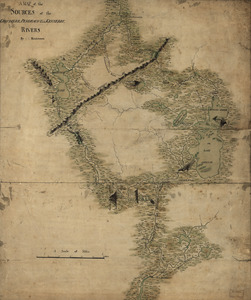
[A map of part of New York, comprehending the country between New York and Quebec, the river Connecticut, &c., to shew "the way from Albany to Canada ..... part by land and part by water;" drawn about 1720, on a scale of 31 miles to an inch]
![[A map of part of New York, comprehending the country between New York and Quebec, the river Connecticut, &c., to shew "the way from Albany to Canada ..... part by land and part by water;" drawn about 1720, on a scale of 31 miles to an inch]](https://bpldcassets.blob.core.windows.net/derivatives/images/commonwealth:6108vw070/image_access_800.jpg)
Item Information
- Title:
- [A map of part of New York, comprehending the country between New York and Quebec, the river Connecticut, &c., to shew "the way from Albany to Canada ..... part by land and part by water;" drawn about 1720, on a scale of 31 miles to an inch]
- Former owner:
- George, III, King of Great Britain, 1738-1820
- Donor:
- George, IV, King of Great Britain, 1762-1830
- Date:
-
[1720?]
- Format:
-
Maps/Atlases
Manuscripts
- Location:
- British Library
- Collection (local):
-
British Library Collection
- Subjects:
-
Portages--New York (State)--Maps, Manuscript--Early works to 1800
Rivers--New York (State)--Maps, Manuscript--Early works to 1800
Rivers--Maine--Maps, Manuscript--Early works to 1800
New York (State)--Maps, Manuscript--Early works to 1800
Connecticut--Maps, Manuscript--Early works to 1800
Maine--Maps, Manuscript--Early works to 1800
Québec (Province)--Maps, Manuscript--Early works to 1800
- Places:
-
Connecticut
Maine
New York
CanadaQuebec (province)
- Extent:
- 1 map on 1 sheet with a separate small sheet comprising the key pasted on : manuscript pen and ink ; 44 x 57 cm
- Terms of Use:
-
No known copyright restrictions.
This work is licensed for use under a Creative Commons Attribution Non-Commercial Share Alike License (CC BY-NC-SA).

- Scale:
-
Scale approximately 1:1,964,160
- Language:
-
English
- Catalog Record:
-
http://explore.bl.uk/BLVU1:LSCOP-ALL:BLL01004987732
- Notes:
-
Title and date taken from the Catalogue of the manuscript maps, charts, and plans, and of the topographical drawings in the British Museum.
The scale is given at lower right. No unit of measurement is given. Miles are assumed for calculating the scale as a representative fraction.
Shows a decorative half rose to the left of the scale.
With a separate key sheet (16 x 17 cm) pasted to the map. Pasted on one side only so the text to both sides is visible. "The Way from albany to Canada described we goe part by land & part by water" comprises a numbered description (1 to 6) followed by "From ye Camp down the Streame" (1 to 6) and "from chamly to Montreall by land is 18 miles by water from Mont royall down the great river of Canada" (1 to 3). The verso gives latitude and longitude for some of the major locations depicted.
Shows forts.
Shows portages.
Shows Fort Ingolsby - buily by Peter Schuyler in 1709.
Names "Woodcreek" (in a different hand and ink?) but does not show the canal built in 1730.
Titled "A drawn Map of part of New york, comprehending the Country between New York and Quebec, the river Connecticut, &c." in the Catalogue of Maps, Prints, Drawings, etc., forming the geographical and topographical collection attached to the Library of his late Majesty King George the third, etc., London, 1829.
Titled "A map of part of New York, comprehending the country between New York and Quebec, the river Connecticut, &c., to shew "the way from Albany to Canada ..... part by land and part by water;" drawn about 1720, on a scale of 31 miles to an inch; 1 f. 11 in. x 1 f. 6 in." in the Catalogue of the manuscript maps, charts, and plans, and of the topographical drawings in the British Museum.
The sketch map shows the Hudson and Connecticut rivers from the Atlantic northwards to the River Saint Lawrence between Montreal and Quebec. The Penobscot River is also shown (but not the Atlantic coastline from the Connecticut River to the Penobscot River).

![[A map of part of New York, comprehending the country between New York and Quebec, the river Connecticut, &c., to shew "the way from Albany to Canada ..... part by land and part by water;" drawn about 1720, on a scale of 31 miles to an inch]](https://bpldcassets.blob.core.windows.net/derivatives/images/commonwealth:6108vw09j/image_thumbnail_300.jpg)
![[A colored map of the route between Albany and Oswego; drawn about 1756, on a scale of 2 miles to an inch]](https://bpldcassets.blob.core.windows.net/derivatives/images/commonwealth:hx11z3223/image_thumbnail_300.jpg)
![[Map showing the boundary line between the provinces of Massachusetts Bay and Connecticut by Woodward and Saffery in 1642 and as run in 1713]](https://bpldcassets.blob.core.windows.net/derivatives/images/commonwealth:hx11z5641/image_thumbnail_300.jpg)
