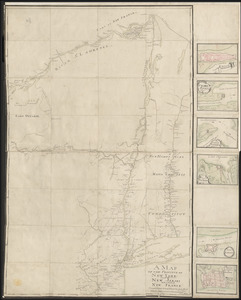
[A colored map of the route between Albany and Oswego; drawn about 1756, on a scale of 2 miles to an inch]
![[A colored map of the route between Albany and Oswego; drawn about 1756, on a scale of 2 miles to an inch]](https://bpldcassets.blob.core.windows.net/derivatives/images/commonwealth:hx11z3223/image_access_800.jpg)
This map is also available in American Revolutionary Geographies Online (ARGO), a collections portal especially built for material relating to the American Revolutionary War Era. Visit ARGO to learn more about this item and explore the historical geography of North America in the late eighteenth century.
Item Information
- Title:
- [A colored map of the route between Albany and Oswego; drawn about 1756, on a scale of 2 miles to an inch]
- Former owner:
- George, III, King of Great Britain, 1738-1820
- Donor:
- George, IV, King of Great Britain, 1762-1830
- Date:
-
1756
- Format:
-
Maps/Atlases
Manuscripts
- Location:
- British Library
- Collection (local):
-
British Library Collection
- Subjects:
-
Rivers--New York (State)--Maps, Manuscript--Early works to 1800
Fortification--New York (State)--Maps, Manuscript--Early works to 1800
New York (State)--Maps, Manuscript--Early works to 1800
Mohawk River (N.Y.)--Maps, Manuscript--Early works to 1800
United States--History--French and Indian War, 1754-1763--Maps, Manuscript--Early works to 1800
- Places:
-
Mohawk (river)
- Extent:
- 1 map on 4 sheets : joined and laid on linen, manuscript pen and ink with watercolour ; 230 x 48 cm
- Terms of Use:
-
No known copyright restrictions.
This work is licensed for use under a Creative Commons Attribution Non-Commercial Share Alike License (CC BY-NC-SA).

- Scale:
-
Scale approximately 1:126,720
- Language:
-
English
- Catalog Record:
-
http://explore.bl.uk/BLVU1:LSCOP-ALL:BLL01004987683
- Notes:
-
Title and date taken from the Catalogue of the manuscript maps, charts, and plans, and of the topographical drawings in the British Museum.
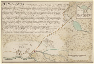
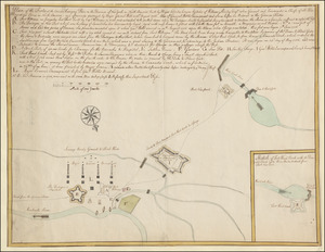
Shows scales at top and bottom as "A scale of 10 miles" where two miles is equal to one inch.
Compass arrows orient north to the right of the map.
Shows forts.
Shows settlements, with some individual properties named.
Shows carrying places.
Shows overland routes.
A note at Wood Creek on the map reads "... Col. Broadhurst had the Creek cleared up from the old Trees & a Dam made just above where the Batteaux take in their loading, so that the carrying place is only now one English mile".
A note just south of Wood Creek on the map reads "The Hook digged through in 1730".
Titled "A drawn Map of the Country between Albany and Oswego. Three sheets" in the Catalogue of Maps, Prints, Drawings, etc., forming the geographical and topographical collection attached to the Library of his late Majesty King George the third, etc., London, 1829.
Titled "a colored map of the route between Albany and Oswego; drawn about 1756, on a scale of 2 miles to an inch: 7 f. 8 in. x 1 f. 7 in." in the Catalogue of the manuscript maps, charts, and plans, and of the topographical drawings in the British Museum.
Shows the route along the Mohawk River and Oswego River from Albany to Fort Oswego.