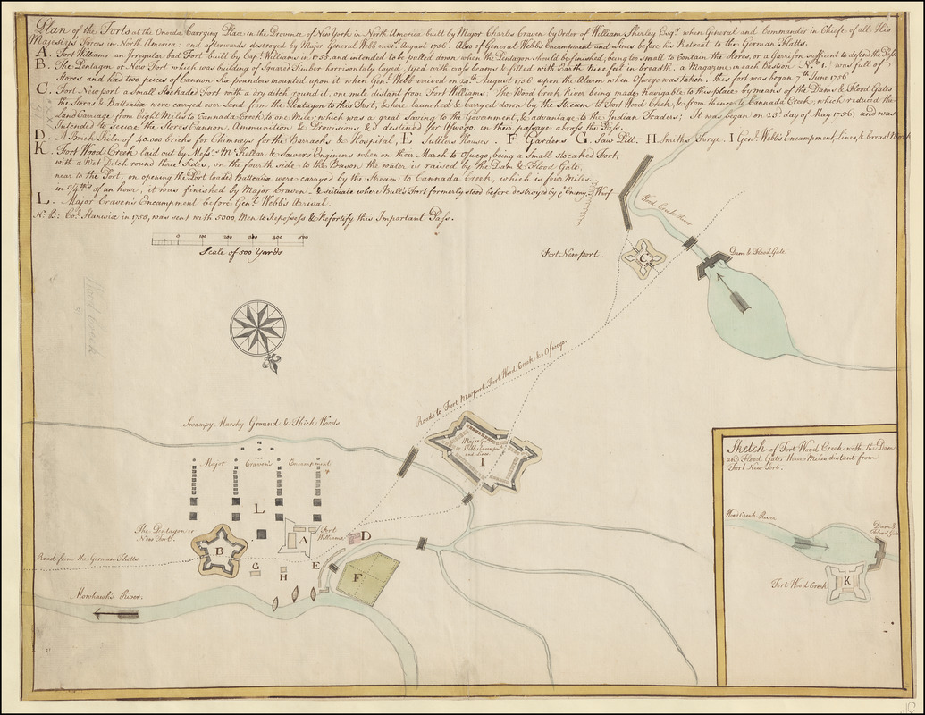
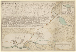
Plan of the Forts at the Onoida or Great Carrying Place in the Province of New York in North America built by Major Charles Craven by Order of William Shirley Esq.r when General and Commander in Chiefe of all His Majesty's Forces in North America; and afterwards destroyed by Major Gen.l Webb on 31st. August 1756. Also of General Webbs Encampment and Lines before his Retreat to the German Flatts
This map is also available in American Revolutionary Geographies Online (ARGO), a collections portal especially built for material relating to the American Revolutionary War Era. Visit ARGO to learn more about this item and explore the historical geography of North America in the late eighteenth century.
Item Information
- Title:
- Plan of the Forts at the Onoida or Great Carrying Place in the Province of New York in North America built by Major Charles Craven by Order of William Shirley Esq.r when General and Commander in Chiefe of all His Majesty's Forces in North America; and afterwards destroyed by Major Gen.l Webb on 31st. August 1756. Also of General Webbs Encampment and Lines before his Retreat to the German Flatts
- Former owner:
- George, III, King of Great Britain, 1738-1820
- Donor:
- George, IV, King of Great Britain, 1762-1830
- Date:
-
1758–1759
- Format:
-
Maps/Atlases
Manuscripts
- Location:
- British Library
- Collection (local):
-
British Library Collection
- Subjects:
-
Fortification--New York (State)--Maps, Manuscript--Early works to 1800
Military art and science--New York (State)--Maps, Manuscript--Early works to 1800
Dams--New York (State)--Oneida County--Maps, Manuscript--Early works to 1800
Mohawk River (N.Y.)--Maps, Manuscript--Early works to 1800
United States--History--French and Indian War, 1754-1763--Maps, Manuscript--Early works to 1800
- Places:
-
Mohawk (river)
Oneida (county)
- Extent:
- 1 map : manuscript pen and ink with watercolour ; 43 x 56 cm
- Terms of Use:
-
No known copyright restrictions.
This work is licensed for use under a Creative Commons Attribution Non-Commercial Share Alike License (CC BY-NC-SA).

- Scale:
-
Scale approximately 1:5,540
- Language:
-
English
- Catalog Record:
-
http://explore.bl.uk/BLVU1:LSCOP-ALL:BLL01016739207
- Notes:
-
Previous British Library cataloguing has attributed a date of 1756 to this map and assumed it is an exact copy of Maps K.Top.121.30. (which it is not). However, Colonel Stanwix in 1758 is referenced on this map. Also, Daniel Webb is referenced as Major-General on the map - a rank which he obtained in 1759 (Cannon, Richard. ed. Robertson, A. Cunningham. Historical record of the King's, Liverpool Regiment of Foot).
Relief is shown by shading.
With a "Scale of 500 Yards" equal to 3 1/4 inches.
A lettered key (A to L) runs on from the title identifying locations of note within the map and providing descriptions of historical events
Shows "The Pentagon or New Fort" (Fort Craven).
Shows "Fort Williams".
Shows "Fort Newport".
With an inset "Sketch of Fort Wood Creek with the Dam and Flood Gate three Miles distant from Fort Newport" at lower right..
Compare this map with Maps K.Top.121.29. and Maps K.Top.121.30. - similarities of hand?
Titled "A drawn Plan of the Forts at the Onoida or Great Carrying Place in the Province of New York, built by Major Craven by order of General Shirley, and destroyed by Major General webb, 31st August 1756" in Catalogue of Maps, Prints, Drawings, etc., forming the geographical and topographical collection attached to the Library of his late Majesty King George the third, etc., London, 1829.
Titled "Another copy of the preceding plan, on the same scale and size. There is added, "N.B. Col. Stanwix, in 1758, was sent with 5000 men to repossess and refortify this important pass" where the preceding is 'A colored "plan of the forts at the Onoida, or great carrying place, in the province of New York in America, built by Major-General Charles Craven, by order of General Shirley, commander-in-chief in North America, and destroyed by Major-General Webb, 31 August, 1756, before they were finished: also of Genl. Webb's encampment within his entrenchment and breastwork, which he quitted 1 Sept., 1756, and retreated to the German Flatts;" drawn on a scale of 150 yards to an inch: with a plan of Fort Wood Creek on a larger scale: 1 f. 9 in. x 1 f. 2 in.' in the Catalogue of the manuscript maps, charts, and plans, and of the topographical drawings in the British Museum.


![[A colored map of the route between Albany and Oswego; drawn about 1756, on a scale of 2 miles to an inch]](https://bpldcassets.blob.core.windows.net/derivatives/images/commonwealth:hx11z3223/image_thumbnail_300.jpg)
