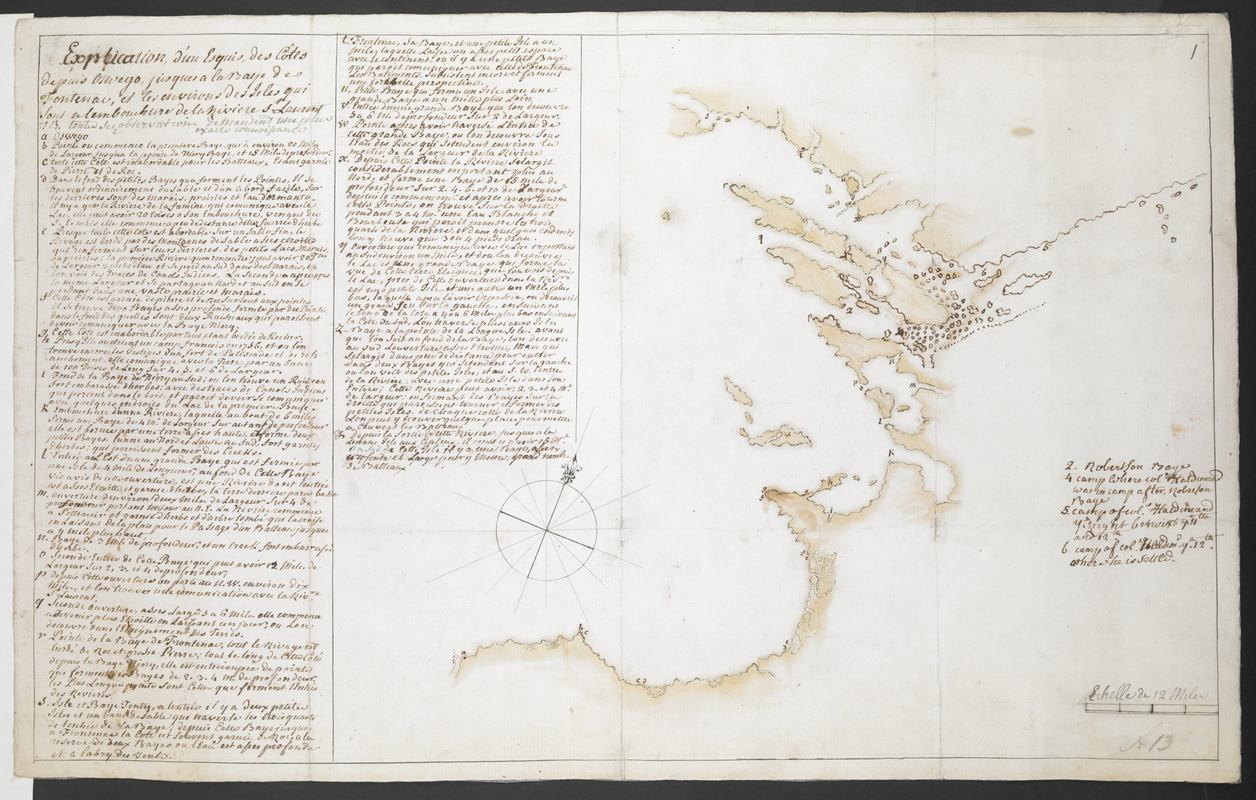
Explication d'un Esquis des Côtes depuis Oswego jusques a la Baye de Frontenac, et les environs des Isle qui Sont en l'embouchure de la Riviere St Laurent N.B. toutes ses observations demandent une plus exactes connoisances
This map is also available in American Revolutionary Geographies Online (ARGO), a collections portal especially built for material relating to the American Revolutionary War Era. Visit ARGO to learn more about this item and explore the historical geography of North America in the late eighteenth century.
Item Information
- Title:
- Explication d'un Esquis des Côtes depuis Oswego jusques a la Baye de Frontenac, et les environs des Isle qui Sont en l'embouchure de la Riviere St Laurent N.B. toutes ses observations demandent une plus exactes connoisances
- Former owner:
- Amherst, Jeffery Amherst, Baron, 1717-1797
- Associated name:
- Haldimand, Frederick. Sir, 1718-1791,
- Former owner:
- Royal United Services Institute for Defence and Security Studies
- Date:
-
[1778]
- Format:
-
Maps/Atlases
- Location:
- British Library
- Collection (local):
-
British Library Collection
- Subjects:
-
Ontario, Lake (N.Y. and Ont.)--Maps, Manuscript--Early works to 1800
- Places:
-
Ontario, Lake
- Extent:
- 1 map : manuscript pen and ink with watercolour ; 29 x 47 cm
- Terms of Use:
-
No known copyright restrictions.
This work is licensed for use under a Creative Commons Attribution Non-Commercial Share Alike License (CC BY-NC-SA).

- Publisher:
-
[Place of production not identified] :
[producer not identified]
- Scale:
-
Scale approximately 1:380,160
- Language:
-
French
- Catalog Record:
-
http://searcharchives.bl.uk/IAMS_VU2:IAMS040-001999738
- Notes:
-
Capt. Wyllamos's Sketch of Lake Ontario - alternative title given in ink on map verso.
Shows the eastern end of Lake Ontario from Oswego to the mouth of the Saint Lawrence River.
Includes an extensive lettered and numbered key (in French) to the left of the map.
Key refers to General Haldimand camped on an island - suggesting a date of production of about 1778 (previous British Library cataloguing suggests a date of about 1760)?
Shows scale bar at lower right, "Echelle de 12 Miles".
Copy at Add Ms 57,708.1. Bound in R.U.S.I. Vol LXXIII. Shows manuscript addition of "1" in pencil at upper right. Shows "A 13" in pencil at lower right. Laid on archival tissue. Green circular label to verso showing "22". White label to verso showing "DRAWER 30 SECTION 2". Blue label to verso showing "A 30/99" and repeated in pencil. Annotation in ink (alternative title) Capt. Wyllamos's Sketch of Lake Ontario". Evidence of old folds. Paper watermark shows a shield with a diagonal strip, surmounted by a fleur de lys, with "LCG" beneath.
- Notes (date):
-
9999
This date is inferred.


![[Lake Ontario]](https://bpldcassets.blob.core.windows.net/derivatives/images/commonwealth:hx11xz576/image_thumbnail_300.jpg)
![Lake Ontario & River S.t Laurence from the Lake to Fort William Augustus in Three Rivers, this was taken from a French Draft that was on Board the Prise Williamson belonging to Monsr La Broquerie [east sheet]](https://bpldcassets.blob.core.windows.net/derivatives/images/commonwealth:hx11z135r/image_thumbnail_300.jpg)
