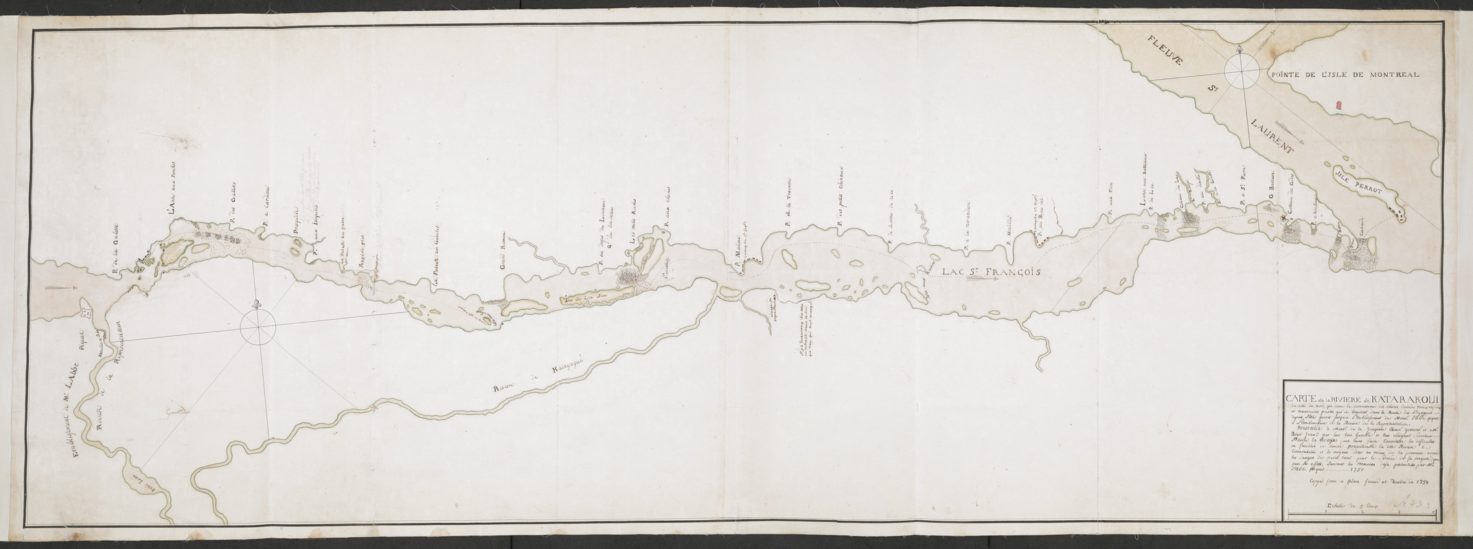
CARTE de la RIVIERE de KATARAKOUI : du cote du nord, qui donne la Connoissance des Chutes, Cascades, Troux, rapides, et mauvais pointes, qui se trouvent dans la Route des Voyageurs depuis l'Isle Perrot jusqua l'etablissement de Mons.r l'Abé Piquet, a l'ambouchure de la Riviere de la Representation. Presentée a Mons.r de la Jonquiere Gouv.r General et a M.r Bigot Inten.t par leur tres humble et tres obeissant Serviteur Paul la Brosse pour leurs faire Connoistre les difficultés ou facilités de rendre practicable la dite Riviere Catarakoui et mes moyens d'oter au moins de la premiere année pour ses effets, suivants les memoires deja presentées par M.r L'abé Piquet ... 1750
This map is also available in American Revolutionary Geographies Online (ARGO), a collections portal especially built for material relating to the American Revolutionary War Era. Visit ARGO to learn more about this item and explore the historical geography of North America in the late eighteenth century.
Item Information
- Title:
- CARTE de la RIVIERE de KATARAKOUI : du cote du nord, qui donne la Connoissance des Chutes, Cascades, Troux, rapides, et mauvais pointes, qui se trouvent dans la Route des Voyageurs depuis l'Isle Perrot jusqua l'etablissement de Mons.r l'Abé Piquet, a l'ambouchure de la Riviere de la Representation. Presentée a Mons.r de la Jonquiere Gouv.r General et a M.r Bigot Inten.t par leur tres humble et tres obeissant Serviteur Paul la Brosse pour leurs faire Connoistre les difficultés ou facilités de rendre practicable la dite Riviere Catarakoui et mes moyens d'oter au moins de la premiere année pour ses effets, suivants les memoires deja presentées par M.r L'abé Piquet ... 1750
- Description:
-
The River Saint Lawrence (not the present-day Cataraqui River) from present-day Ogdensburg on the Oswegatchie River (named here "Riviere de la Representation") eastwards as far as the lower part of the Montreal Island.
- Associated name:
- Labrosse, Paul, 1697-1769
- Associated name:
- La Jonquie?re, Jacques-Pierre de Taffanel de, 1685-1752
- Associated name:
- Bigot, Franc?ois, 1703-1778
- Former owner:
- Amherst, Jeffery Amherst, Baron, 1717-1797
- Former owner:
- Royal United Services Institute for Defence and Security Studies
- Name on Item:
-
Copyed from a plan found at Quebec in 1759.
- Date:
-
[ca. 1759]
- Format:
-
Maps/Atlases
- Location:
- British Library
- Collection (local):
-
British Library Collection
- Subjects:
-
Fortification--Saint Lawrence River--Maps, Manuscript--Early works to 1800
Navigation--Saint Lawrence River--Maps, Manuscript--Early works to 1800
Saint Lawrence River--Maps, Manuscript--Early works to 1800
- Places:
-
Saint Lawrence River
- Extent:
- 1 map on 2 sheets : joined, manuscript pen and ink with watercolour over pencil ; 50 x 139 cm
- Terms of Use:
-
No known copyright restrictions.
This work is licensed for use under a Creative Commons Attribution Non-Commercial Share Alike License (CC BY-NC-SA).

- Publisher:
-
[Place of production not identified] :
[producer not identified]
- Scale:
-
Scale approximately 1:132,000
- Language:
-
French
- Catalog Record:
-
http://searcharchives.bl.uk/IAMS_VU2:IAMS040-001999740
- Notes:
-
An English (?) copy (made in 1759) of a French map (made in 1750). Copy statement (within title) in English. All other text in French.
French title suggests original map was presented to Jonquiere and Labrosse.
Shows forts and other defences in red.
Geographic detail is shown on the river and banks only.
Shows title in a simple surround at lower left, including the scale bar "Echelle de 5 lieux").
Copy at Add Ms 57,710.2. In a solander box, R.U.S.I. Vol LXXV and LXXVIII. Comprises 2 sheets, joined and laid on linen. Shows "A 43" and "1" in pencil at lower left. Green circular label to verso showing "16". White label to verso showing "DRAWER 28 SECTION 2". Blue label to verso showing "A 28/41". Pressmark stamped to verso in black ink.
- Notes (date):
-
9999

![[Sketch map of an unidentified fort]](https://bpldcassets.blob.core.windows.net/derivatives/images/commonwealth:hx11z101x/image_thumbnail_300.jpg)
![[An unfinished chart of the Saint Lawrence River from Perrot Island to the Island of Orleans]](https://bpldcassets.blob.core.windows.net/derivatives/images/commonwealth:hx11z0836/image_thumbnail_300.jpg)
![[Map showing the location of Fort de la Presentation]](https://bpldcassets.blob.core.windows.net/derivatives/images/commonwealth:hx11z0993/image_thumbnail_300.jpg)
