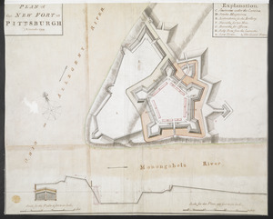
[A map of Lake Erie with the route southward from Fort Presqu'Isle to Fort Cumberland, with inset plans of Fort Pitt, Fort Venango, Fort Le Boeuf and Fort Presque Isle]
![[A map of Lake Erie with the route southward from Fort Presqu'Isle to Fort Cumberland, with inset plans of Fort Pitt, Fort Venango, Fort Le Boeuf and Fort Presque Isle]](https://bpldcassets.blob.core.windows.net/derivatives/images/commonwealth:6108vw18h/image_access_800.jpg)
This map is also available in American Revolutionary Geographies Online (ARGO), a collections portal especially built for material relating to the American Revolutionary War Era. Visit ARGO to learn more about this item and explore the historical geography of North America in the late eighteenth century.
Item Information
- Title:
- [A map of Lake Erie with the route southward from Fort Presqu'Isle to Fort Cumberland, with inset plans of Fort Pitt, Fort Venango, Fort Le Boeuf and Fort Presque Isle]
- Former owner:
- George, III, King of Great Britain, 1738-1820
- Donor:
- George, IV, King of Great Britain, 1762-1830
- Contributor:
- Braddock, Edward, 1695?-1755
- Date:
-
1760–1763
- Format:
-
Maps/Atlases
Manuscripts
- Location:
- British Library
- Collection (local):
-
British Library Collection
- Subjects:
-
Fortification--New York (State)--Maps, Manuscript--Early works to 1800
Lakes--Erie, Lake--Maps, Manuscript--Early works to 1800
Erie, Lake--Maps, Manuscript--Early works to 1800
Pennsylvania--Maps, Manuscript--Early works to 1800
Fort Pitt (Pa.)--Maps, Manuscript--Early works to 1800
United States--History--French and Indian War, 1754-1763--Maps, Manuscript--Early works to 1800
- Places:
-
New York
Allegheny (county)Pittsburgh
Erie, Lake
- Extent:
- 1 map on 6 sheets : joined and laid on linen, manuscript pen and ink with water colour ; 129 x 147 cm
- Terms of Use:
-
No known copyright restrictions.
This work is licensed for use under a Creative Commons Attribution Non-Commercial Share Alike License (CC BY-NC-SA).

- Scale:
-
Scale approximately 1:300,000
- Language:
-
English
- Catalog Record:
-
http://explore.bl.uk/BLVU1:LSCOP-ALL:BLL01004987731
- Notes:
-
Previous British Library cataloguing has dated this map between 1758 and 1764. However, the depiction of Fort Venango suggests a different date - the fort was built in 1760 and was destroyed in 1763.
Relief is shown pictorially.
With inset plans of Fort Pitt (at a scale of 200 feet to an inch, 1:2400), Fort Venango, Fort Le Boeuf and Fort Presque Isle (each at a scale of 100 feet to an inch, 1:1200).
Shows General Braddock's road.
With a decorative compass rose in Lake Erie orienting north to the top of the map.
With decorative (foliate) letters spelling "Lake Erie".
A reproduction of a small section of this map is held by the Dartington Memorial Library at the University of Pittsburgh and is detailed in Lloyd Arnold Brown's Early maps of the Ohio Vallery. Brown attributes the original map to John Hills? with a date of about 1766, but Hills did not travel to America until 1775 (Guthorn, Peter J. John Hills Assistant Engineer).
Compare a similar map - Add Ms 57,714.2.
Titled "A drawn Map of Lake Erie and the adjacent country. Four sheets" in the Catalogue of Maps, Prints, Drawings, etc., forming the geographical and topographical collection attached to the Library of his late Majesty King George the third, etc., London, 1829.
Titled "A colored chart of Lake Erie, with the route southward, from Fort Presqu'ile, by Fort Le Beuf, Fort Venango, Fort Pitt, (on the Ohio) to Fort Cumberland on the Potomac, shewing General Braddock's march, in 1755: drawn on a scale of 5 miles to an inch; with plans of Fort Pitt, on a scale of 200 feet to an inch; and of Fort Venango, Fort le Beuf, and Fort Presqu'ile, on a scale of 100 feet to an inch: 4 f. 10 in. x 4 f. 2 in." in the Catalogue of the manuscript maps, charts, and plans, and of the topographical drawings in the British Museum.

![[A colored map of the route between Albany and Oswego; drawn about 1756, on a scale of 2 miles to an inch]](https://bpldcassets.blob.core.windows.net/derivatives/images/commonwealth:hx11z3223/image_thumbnail_300.jpg)

