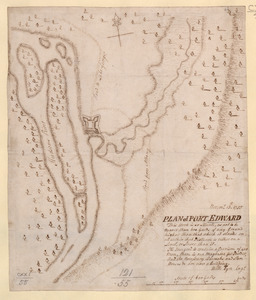
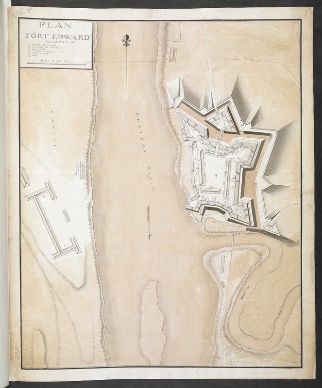
PLAN FORT EDWARD
This map is also available in American Revolutionary Geographies Online (ARGO), a collections portal especially built for material relating to the American Revolutionary War Era. Visit ARGO to learn more about this item and explore the historical geography of North America in the late eighteenth century.
Item Information
- Title:
- PLAN FORT EDWARD
- Associated name:
- Sowers, Thomas
- Former owner:
- Amherst, Jeffery Amherst, Baron, 1717-1797
- Former owner:
- Royal United Services Institute for Defence and Security Studies
- Date:
-
[ca. 1759]
- Format:
-
Maps/Atlases
- Location:
- British Library
- Collection (local):
-
British Library Collection
- Subjects:
-
Fortification--New York (State)--Fort Edward--Maps, Manuscript--Early works to 1800
Military art and science--New York (State)--Fort Edward--Maps, Manuscript--Early works to 1800
Fort Edward (N.Y.)--Maps, Manuscript--Early works to 1800
- Places:
-
Washington (county)Fort Edward
- Extent:
- 1 map : manuscript pen and ink with watercolour ; 61 x 50 cm
- Terms of Use:
-
No known copyright restrictions.
This work is licensed for use under a Creative Commons Attribution Non-Commercial Share Alike License (CC BY-NC-SA).

- Publisher:
-
[Place of production not identified] :
[Producer not identified]
- Scale:
-
Scale approximately 1:720
- Language:
-
English
- Catalog Record:
-
http://searcharchives.bl.uk/IAMS_VU2:IAMS040-001999743
- Notes:
-
Date suggested as barracks, a store house and bake ovens are shown on Rogers Island.
Relief shown by shading and by hachuring.
Shows title at upper left in a simple surround incorporating the lettered key (a-g), which identifies buildings within Fort Edward, and the scale bar showing "Scale of 240 Feet".
Names "Hudsons River".
Shows "Garden" at lower right.
Previous British Library cataloguing suggests Thomas Sowers as possible cartographer.
Copy at Add Ms 57,711.7. Bound in R.U.S.I. Vol LXXVI. Shows manuscript addition of "7" in pencil at upper right. Shows "A 62" in pencil at lower left and "A 28/66" at upper left. Laid on archival tissue. Green circular label to verso shows "9". White label to verso shows "DRAWER 28 SECTION 1". Blue label to verso shows "A 28/66". Paper watermark shows a fleur de lys within a shield, surnounted by a crown, with "LVG" beneath.
- Notes (date):
-
9999