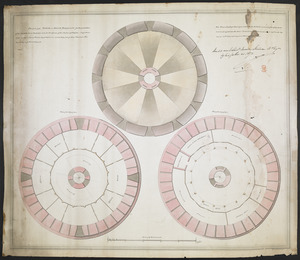
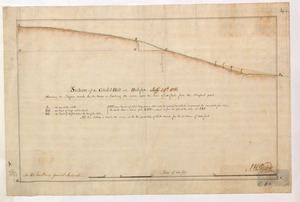
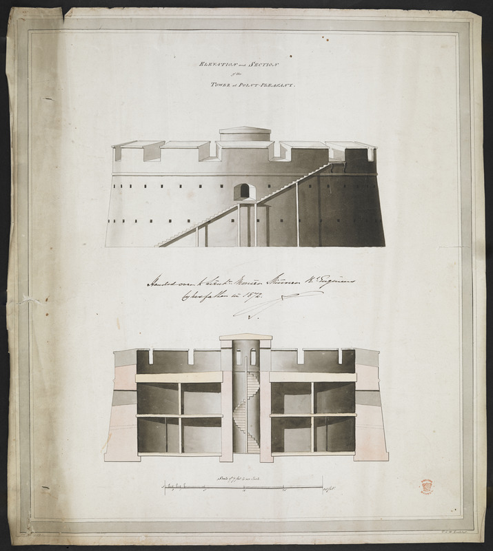
ELEVATION and SECTION of the TOWER at POINT PLEASANT
This map is also available in American Revolutionary Geographies Online (ARGO), a collections portal especially built for material relating to the American Revolutionary War Era. Visit ARGO to learn more about this item and explore the historical geography of North America in the late eighteenth century.
Item Information
- Title:
- ELEVATION and SECTION of the TOWER at POINT PLEASANT
- Description:
-
The Martello tower in Point Pleasant Par, Halifax, Nova Scotia.
- Cartographer:
- Eastcliff, T. G. W.
- Associated name:
- Edward Augustus, Prince, Duke of Kent, 1767-1820
- Associated name:
- Straton, James
- Former owner:
- Skinner, William, 1700-1780
- Former owner:
- Skinner, Monier
- Date:
-
1799
- Format:
-
Maps/Atlases
- Location:
- British Library
- Collection (local):
-
British Library Collection
- Subjects:
-
Military art and science--Nova Scotia--Halifax--Maps, Manuscript--Early works to 1800
Fortification--Nova Scotia--Halifax--Maps, Manuscript--Early works to 1800
Martello towers--Nova Scotia--Halifax--Maps, Manuscript--Early works to 1800
Point Pleasant Park (Halifax, N.S.)--Maps, Manuscript--Early works to 1800
- Places:
-
CanadaHalifax
- Extent:
- 1 map : manuscript pen and ink with watercolour ; 44 x 39 cm
- Terms of Use:
-
No known copyright restrictions.
This work is licensed for use under a Creative Commons Attribution Non-Commercial Share Alike License (CC BY-NC-SA).

- Publisher:
-
[Place of production not identified] :
T. G. W. Eastcliff,
- Scale:
-
Scale approximately 1:204
- Language:
-
English
- Catalog Record:
-
http://searcharchives.bl.uk/IAMS_VU2:IAMS040-002027388
- Notes:
-
Date in margin at lower left.
Shows title at upper centre.
Shows scale bar at lower centre, "Scale of 17 Feet to an Inch".
Shows "T. G. W. Eastcliff" in margin at lower right.
See also Add Ms 33,231.LL.1.
Copy at Add Ms 33,231.LL.2. A roll. Shows inscription at centre, "Handed over to Lieut. Monier Skinner E. Eng.t by his father in 1872".
- Notes (date):
-
9999