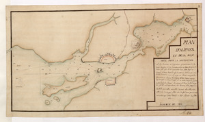
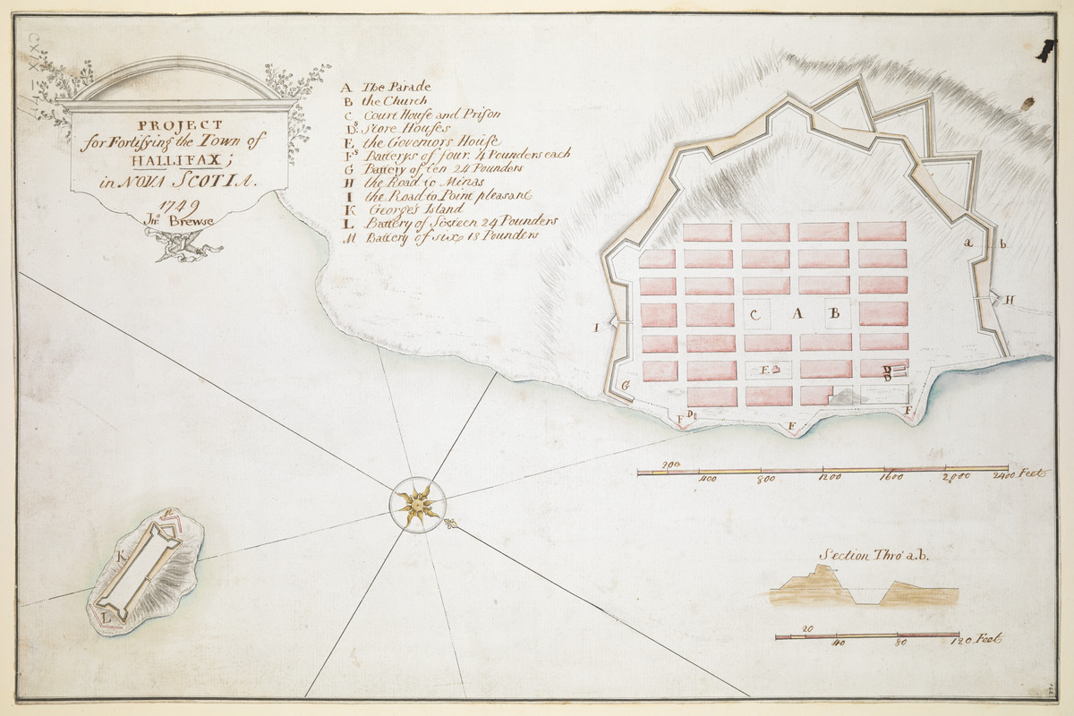
PROJECT for Fortifying the Town of HALLIFAX ; in NOVA SCOTIA
This map is also available in American Revolutionary Geographies Online (ARGO), a collections portal especially built for material relating to the American Revolutionary War Era. Visit ARGO to learn more about this item and explore the historical geography of North America in the late eighteenth century.
Item Information
- Title:
- PROJECT for Fortifying the Town of HALLIFAX ; in NOVA SCOTIA
- Title (alt.):
-
PROJECT for Fortifying the Town of HALIFAX ; in NOVA SCOTIA
- Description:
-
A manuscript map by John Brewse illustrating the proposals and projections for Halifax in Nova Scotia.
- Cartographer:
- Brewse, John, -1785
- Former owner:
- George, III, King of Great Britain, 1738-1820
- Donor:
- George, IV, King of Great Britain, 1762-1830
- Name on Item:
-
1749 Jn: Brewse.
- Date:
-
1749
- Format:
-
Maps/Atlases
Manuscripts
- Location:
- British Library
- Collection (local):
-
British Library Collection
- Subjects:
-
Military art and science--Nova Scotia--Halifax--Maps, Manuscript--Early works to 1800
Halifax (N.S.)--Maps, Manuscript--Early works to 1800
- Places:
-
CanadaHalifax
- Extent:
- 1 map : manuscript, pen and ink with watercolour ; 28 x 43 cm
- Terms of Use:
-
No known copyright restrictions.
This work is licensed for use under a Creative Commons Attribution Non-Commercial Share Alike License (CC BY-NC-SA).

- Scale:
-
Scale approximately 1:4,800
- Language:
-
English
- Catalog Record:
-
http://explore.bl.uk/BLVU1:LSCOP-ALL:BLL01004987904
- Notes:
-
Title appears in a decorative surround at upper left.
Lettered key (A-M) identifies locations within the town.
A decorative compass rose orients north to the right of the sheet.
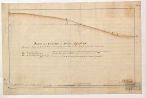
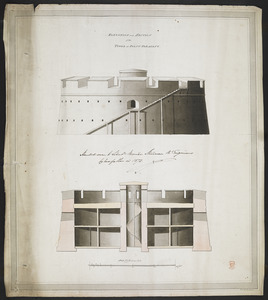
Cross section of the town walls is given at lower right at a scale of one inch to 40 feet.
"George's Island" with the "Battery of Sixteen 24 Pounders" is shown in the harbour.
Library and Archives Canada, H3/240/Halifax/1749, NMC 4676 holds another copy of the map (Red'd with Col Cornwallis's letter dated ye 17 Oct. 1749.).
The "Index of Manuscripts in the British Library" lists other manuscript letters by John Brewse.
Titled 'A drawn Project for fortifying the Town of Halifax, by John Brewse, 1749' in the Catalogue of Maps, Prints, Drawings, etc., forming the geographical and topographical collection attached to the Library of his late Majesty King George the third, etc., London, 1829.
Titled 'A colored "Project for fortifying the Town of Hallifax, ... 1749, by John Brewse;" drawn on a scale of 400 feet to an inch: 1 f. 4 1/2 in. x 11 in.' in the Catalogue of the manuscript maps, charts, and plans, and of the topographical drawings in the British Museum.