Toggle navigation
LMEC Home
Exhibitions
Georeferencing
Tools for Teachers
Collections
My Favorites
Sign Up / Log In
Search
Search the map portal
Map Collection
Map Collection
Map Sets
Search
Search
Search for
Search In
All Fields
Creator
Title
Subject
Place
Search All Digital Collections
Advanced Search
8655 Results
My Search
Start Over
More Like
commonwealth:6h446r92h
Remove constraint More Like: commonwealth:6h446r92h
Filter your Search
Place
North and Central America
5,950
United States
4,874
Massachusetts
2,063
Europe
1,359
Suffolk (county)
1,139
Boston
1,112
Canada
448
Asia
422
more
Place
»
Topic
Boston (Mass.)--Maps
598
United States--Maps
273
Real property--Massachusetts--Boston--Maps
252
Landowners--Massachusetts--Boston--Maps
169
Massachusetts--Maps
160
City planning--Massachusetts--Boston--Maps
131
North America--Maps--Early works to 1800
103
New England--Maps
99
more
Topic
»
Date
Date range begin
–
Date range end
Current results range from
1482
to
2023
View distribution
Creator
United States. Hydrographic Office
594
O.H. Bailey & Co
148
Boston Redevelopment Authority
132
Des Barres, Joseph F. W. (Joseph Frederick Wallet), 1722-1824
123
United States. Post Office Dept
120
Ptolemy, 2nd cent
100
Walling, Henry Francis, 1825-1888
94
Geological Survey (U.S.)
86
more
Creator
»
Format
Maps/Atlases
8,596
Manuscripts
215
Prints
56
Books
36
Objects/Artifacts
10
Drawings/Illustrations
8
Posters
4
Georeferenced
Yes
870
No
7,785
Collection
Norman B. Leventhal Map & Education Center Collection
8,551
Boston and New England Maps
2,274
Urban Maps
2,006
Maritime Charts and Atlases
1,081
American Revolutionary War-Era Maps
616
Boston Redevelopment Authority Collection
156
Massachusetts Real Estate Atlases
35
Mapping Boston Collection
1
Available to use
No known restrictions
8,478
Creative Commons license
47
Search Constraints
Sort by relevance
relevance
title
date (asc)
date (desc)
Number of results to display per page
100 per page
10
per page
20
per page
50
per page
100
per page
View results as:
grid view
map view
Search Results
7901.
The theatre of war in North America, with the roads, and tables, of the superficial contents, distances, &ca
7902.
Thermal map of North America, delineating the isothermal zodiac, the isothermal axis of intensity, and its expansions up and...
7903.
These United States : products & industries
7904.
Thirteenth Amendment, January 31, 1865, Vote on passage of resolution submitting
7905.
Thirty-miles round Boston
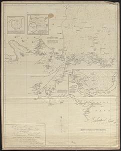
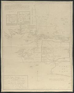
7906.
This harbour of Boston
7907.
This harbour of Boston
7908.
This map of North America, according to ye newest and most exact observations is most humbly dedicated by your Lordship's most...
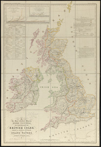
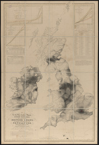
7909.
This map of Scotland
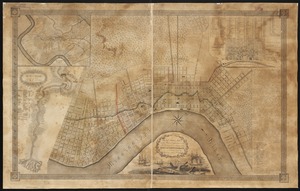
7910.
This map of South America, according to the newest and most exact observations
7911.
This map presents a Bostonian's idea of the United States of America
7912.
This plan contains about 1000 acres, of the Canton Company's Land
7913.
This plan of the city of Philadelphia and it's [sic] environs, (shewing the improved parts,) is dedicated to the mayor,...
7914.
Three Rivers, Mass
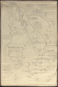
7915.
Thunder Bay, Lake Huron
7916.
Thun-Interlaken
7917.
Tierra nveva
7918.
Tilton, N.H., Belknap County : 1884
7919.
The Times-Picayune's map of New Orleans
7920.
Title page of Theatrum Orbis Terrarum
7921.
To Captain Krusenstern, of the Imperial Russian Navy, as a tribute for his laudable exertions to benefit navigation and...
7922.
To Captain Krusenstern, of the Imperial Russian Navy, as a tribute for his laudable exertions to benefit navigation and...
7923.
To Chas. Marjoribanks esqre. and the other members of the Honble. East India Company's factory at Canton, this chart of Choo...
7924.
To General Andrew Jackson and his brave companions in arms on the 8th of Jany. 1815 this plan of the city of New Orleans is...
7925.
To her most excellent majesty Queen Victoria this hydrographical map of the British Isles, exhibiting the geographical...
7926.
To her most excellent majesty Queen Victoria this map of the British Isles, elucidating the distribution of the population,...
7927.
To Her most Sacred Majesty Carolina Queen of Great Britain, France & Ireland, this map of Europe, according to the newest and...
7928.
To his excellency the Count of Czernichew, Commander in Chief of her Majesty the Empress, of all the Russia's fleet and...
7929.
To His Excellency William Burnet, Esqr., this Plan of Boston in New England is humbly dedicated
7930.
To his excellency William Shirley Esqr., Captain General and Commander in Chief, in and over his Majesty's province of the...
7931.
To His Most Serene and August Majesty Peter Alexovitz absolute lord of Russia &c. this map of Moscovy, Poland, Little Tartary,...
7932.
To James Carnegy and Robert Scott Esqrs. of Prince of Wales Island, as a tribute due for their valuable communications which...
7933.
To the Great Czar of Moscovie this Map of Tartary &c. is humbly dedicated
7934.
To the Honble. the Court of Directors of the United East India Company, this chart, intended as an accompaniment to the book of...
7935.
To the Honble. the Court of Directors of the United East India Company, this chart, intended as an accompaniment to the book of...
7936.
To the Honourable Thomas Penn and Richard Penn, Esqrs., true & absolute proprietaries & Governours of the Province of...
7937.
To the honourable Walter Younge, barronet, one of the commissioners for his majestie's collonis : this description of New...
7938.
To the Right Honorable the Master, Wardens & Elder Brethren of the Trinity House, this Chart of Plymouth Sound is ... dedicated
7939.
To the right honorable the master, wardens & elder brethren of the Trinity House, this chart of Spithead is ... dedicated
7940.
To the Right Honorable the Master, Wardens, and Elder Brethren, of the Trinity House, this chart of the Downs and Margate Roads...
7941.
To the Right Honourable Charles, Earl of Peterborow, and Monmouth, &c. this map of Africa, according to ye newest and most...
7942.
To the Right Honourable, Charles Earl of Sunderland, and Baron Spencer of Wormleighton, one of Her Majesty's principal...
7943.
To the Right Honourable John Lord Sommers, Baron of Evesham in ye county of Worcester, president of Her Majesty's most...
7944.
To the Right Honourable the Master, Wardens, & Elder Bretham of the Trinity House, this chart of the entrances to The River...
7945.
To the Right Honourable William, Lord Cowper, Lord High Chancellor of Great Britain, this map of Asia : according to ye newest...
7946.
To the select-men of the town of Boston, in the Commonwealth of Massachusetts; ever distinguished for their zeal for the good...
7947.
Tobago
7948.
Tobago from actual surveys and observations
7949.
Tomlinsons map of Petersburg : showing the scene of Genl. Grants operations
7950.
Tonto National Forest, Arizona
7951.
Topographia aug. Turon. ducatus et confinium Galliae celticae sinu complectitur cuius latitudo ab aequinoctiali versus...
7952.
Topographic & detail sheets of Rainy Lake & upper boundary waters
7953.
Topographic map of Brighton and Allston
7954.
Topographic map of Clinton County, Illinois
7955.
Topographic map of Gallatin County, Illinois
7956.
Topographic map of Hardin County, Illinois
7957.
Topographic map of Lawrence County, Illinois
7958.
The topographic map of Manchoukuo
7959.
Topographic map of Massachusetts and Rhode Island
7960.
Topographic map of McDonough County, Illinois
7961.
Topographic map of Monroe County, Illinois
7962.
Topographic map of Randolph County, Illinois
7963.
Topographic map of the Island of Niihau, Kauai County, Hawaii
7964.
Topographic map of the Plattsburg Training Camp, New York
7965.
A topographical chart of the bay of Narraganset in the province of New England : with all the isles contained therein, among...
7966.
Topographical map, Gettysburg-Antietam
7967.
Topographical map of Blue Hills Reservation
7968.
Topographical map of Cedar Square, Roxbury
7969.
A topographical map of Essex County, Massachusetts : based upon the trigonometrical survey of the state
7970.
Topographical map of Fairmount Park, Philadelphia : excepting Wissahickon Valley
7971.
A topographical map of Hampshire County Massachusetts : based upon the trigonometrical survey of the state
7972.
Topographical map of Meekatharra
7973.
Topographical map of Middlesex Fells Reservation
7974.
Topographical map of Pittsfield, Berkshire Co., Mass : from actual surveys and records
7975.
A topographical map of Steuben Co., New York : from actual surveys
7976.
Topographical map of the approaches and defences of Knoxville, E. Tennessee, shewing the positions occupied by the United...
7977.
Topographical map of the City and County of New-York, and the adjacent country : with views in the border of the principal...
7978.
Topographical map of the counties of St. John and Kings, New Brunswick
7979.
Topographical map of the District of Columbia
7980.
Topographical map of the District of Columbia and a portion of Virginia
7981.
A topographical map of the island of Barbados : based upon Mayo's original survey in 1721 and corrected to the year 1846
7982.
A topographical map of the northn. part of New York Island, exhibiting the plan of Fort Washington, now Fort Knyphausen, with...
7983.
Topographical map of the province of lower Texas on the Gulf of Mexico
7984.
Topographical map of the Rocky Mountains : Lake Louise sheet
7985.
Topographical map of the Rocky Mountains : Banff sheet
7986.
Topographical map of the seat of the war
7987.
Topographical map of the State of Massachusetts
7988.
A topographical map of the State of New Hampshire
7989.
A topographical map of the state of New Hampshire
7990.
Topographical map of the state of Rhode Island and Providence plantations
7991.
A topographical map of the state of Rhode-Island and Providence Plantations
7992.
A topographical map of the White Mountains, of New Hampshire
7993.
Topographical map of Virginia between Washington and Manassas Junction
7994.
Topographical map of Westmoreland and Albert Counties : from actual surveys by D.J. Lake and H.S. Peck
7995.
A topographical plan of modern Rome with the new additions
7996.
Topographical plan of the north shore of Lake Huron shewing recent surveys
7997.
Topographical sketch of Lake George
7998.
Topographical sketch of the grounds of the State Insane Asylum, Danvers, Mass : Showing location of the buildings, roads, &c
7999.
A topographicall description and admeasurement of the yland of Barbados in the West Indyaes : with the mrs. names of the...
8000.
Topographische Carte : Hundert Quadrat-Meilen um Berlin
‹ Prev
Next ›
1
2
…
76
77
78
79
80
81
82
83
84
…
86
87