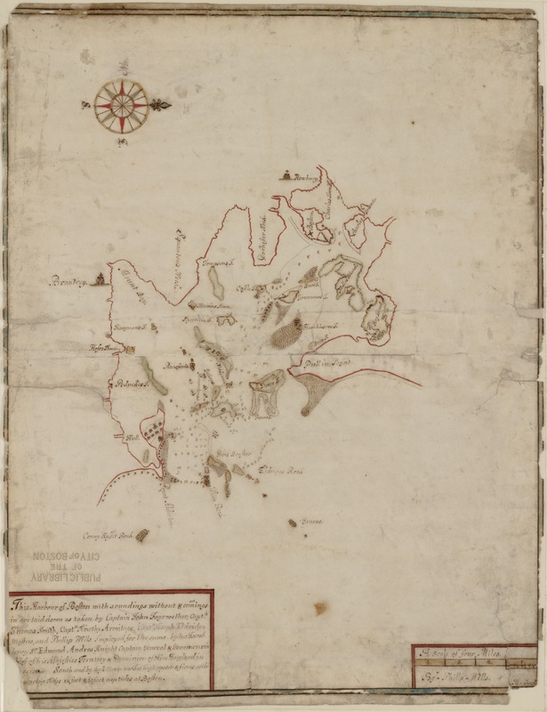
This harbour of Boston
Item Information
- Title:
- This harbour of Boston
- Title (alt.):
-
Harbour of Boston
Harbor of Boston
- Description:
-
Although undated, this earliest surviving plan of Boston Harbor dates from the period of Sir Edmund Andros' term as governor of New England from 1685-1689. It is most likely one of several manuscript maps of New England sent by Andros back to the Board of Trade in London. Andros was known to have received orders to secure a map of Boston Harbor as early as April 1688. The chart was prepared by Phillip Wells, one of the most highly skilled of early American cartographers, based on information provided by several ship captains. Few other important 17th-century manuscript maps of the New England colonies have survived. It is also of interest that the earliest printed chart of Boston Harbor, which was published as part of "The English Pilot: The Fourth Book" (1689), shows many similarities to this map.
- Creator:
- Wells, Phillip.
- Name on Item:
-
with soundings without & comings in are laid down as taken by Captain John Fayrwether, Captn. Thomas Smith, Captn. Timothy Armitage, Captn. Joseph Eldridge Masters, and Phillip Wells, imployed for the same by his Excellency Sr. Edmund Andros Knight, Captain General and Governour in Chief of his Majesties territory & dominion of New England in [Am]erica.
- Date:
-
[1688?]
- Format:
-
Maps/Atlases
Manuscripts
- Location:
-
Boston Public Library
Norman B. Leventhal Map & Education Center - Collection (local):
-
Norman B. Leventhal Map & Education Center Collection
- Subjects:
-
Nautical charts--Massachusetts--Boston Harbor--Early works to 1800
Massachusetts--Boston Harbor--Maps, Manuscript--Early works to 1800
- Places:
-
MassachusettsBoston Harbor
- Extent:
- 1 ms. map : col. ; on sheet 59 x 46 cm.
- Terms of Use:
-
No known copyright restrictions.
No known restrictions on use.
- Scale:
-
Scale [ca. 1:253,000]
- Language:
-
English
- Notes:
-
Depth shown by soundings.
Oriented with north to the right.
At lower right: "M. Carroll."
- Notes (exhibitions):
-
Exhibited in “Faces and Places,” at the Boston Public Library, Boston, MA, October 2003 - September 2004. MB (BRL)
Exhibited: "Made in Boston" organized by the Norman B. Leventhal Map Center at the Boston Public Library, 2013-2014.
- Identifier:
-
06_01_000065
- Call #:
-
G3762.B65 1688 .W4
- Barcode:
-
39999052509310


