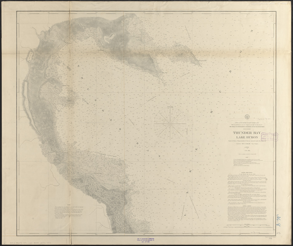
Thunder Bay, Lake Huron
Item Information
- Title:
- Thunder Bay, Lake Huron
- Title (uniform):
-
Survey of the northern and northwestern lakes
- Issuing body:
- U.S. Lake Survey
- Surveyor:
- Potter, J. A.
- Surveyor:
- Turnbull, C. N.
- Surveyor:
- Carr, James
- Surveyor:
- Smith, W. P.
- Surveyor:
- Lamson, George W.
- Surveyor:
- Lamson, A.
- Surveyor:
- Henry, D. Farrand (Daniel Farrand), 1833-1907
- Draftsman:
- Barney, Joshua, 1799 or 1800-1867
- Contributor:
- United States. Topographical Bureau
- Engraver:
- Dougal, William H., 1822-1895
- Surveyor:
- Meade, George Gordon, 1815-1872
- Name on Item:
-
projected from a trigonometrical survey executed under the orders of Captain Geo. G. Meade, Top. Engrs. in 1858 ; off shore hydrography by Capt. Geo. G. Meade, Top. Engrs. assisted by asst. J.A. Potter ; astronomical observations by Lieut. C.N. Turnbull, Top. Engrs. assisted by asst. James Carr ; magnetic observations by Lieut. W.P. Smith, Top. Engrs. ; measurement of base line and triangulation by asst. G.W. Lamson ; shore line topography and hydrography by asst. G.W. Lamson assisted by assts. D.E. Henry and A. Lamson ; reduced for engraving by asst. Joshua Barney ; engraved by W.H. Dougal
- Date:
-
[1891]
- Format:
-
Maps/Atlases
- Location:
-
Boston Public Library
Norman B. Leventhal Map & Education Center - Collection (local):
-
Norman B. Leventhal Map & Education Center Collection
- Subjects:
-
Nautical charts--Michigan--Thunder Bay
Nautical charts--Huron, Lake (Mich. and Ont.)
Thunder Bay (Mich.)--Maps
Huron, Lake (Mich. and Ont.)--Navigation--Maps
- Places:
-
MichiganAlpena (county)Thunder Bay
Huron, Lake
- Extent:
- 1 map ; 73 x 85 cm.
- Terms of Use:
-
No known copyright restrictions.
No known restrictions on use.
- Publisher:
-
[Washington, D.C.] :
[U.S. Lake Survey]
- Scale:
-
Scale 1:40,000
- Language:
-
English
- Notes:
-
Also shows some points of interest and composition of river bottom.
Depth shown by soundings and gradient tints.
"Made in obedience to acts of Congress and under the direction of the Bureau of Topographical Engineers of the War Department."
"Aids to navigation corrected to January 1, 1880."
Seal with "Survey of the lakes 1860" at head of title.
Includes sailing directions, general remarks and 2 notes.
Stamped in purple at bottom: Aids to navigation corrected from information received to Jun 17 1891.
- Notes (date):
-
This date is inferred.
- Notes (citation):
-
Checklist of printed maps of the Middle West, 5-3751
- Identifier:
-
06_01_015587
- Call #:
-
G4112.T52P5 1891 .U83
- Barcode:
-
39999085937892