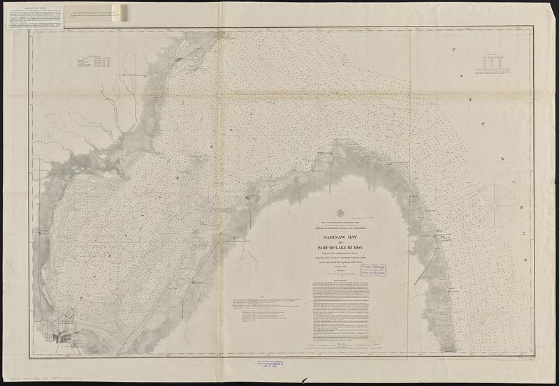
Saginaw Bay and part of Lake Huron
Item Information
- Title:
- Saginaw Bay and part of Lake Huron
- Issuing body:
- U.S. Lake Survey
- Surveyor:
- Macomb, J. N. (John N.), 1810 or 1811-1889
- Surveyor:
- Meade, George Gordon, 1815-1872
- Draftsman:
- Mueller, J. U. (John U.)
- Engraver:
- Dougal, William H., 1822-1895
- Contributor:
- United States. Topographical Bureau
- Name on Item:
-
projected from a trigonometrical survey under the orders of Capt. J.N. Macomb, Topl. Engrs. in 1856 and of Capt. G.G. Meade, Topl. Engrs. in 1857 & 1858 ; reduced for engraving by J.U. Mueller, Assistant U.S.L.S. ; engraved by W.H. Dougal
- Date:
-
1892
- Format:
-
Maps/Atlases
- Genre:
-
Nautical charts
- Location:
-
Boston Public Library
Norman B. Leventhal Map & Education Center - Collection (local):
-
Norman B. Leventhal Map & Education Center Collection
- Subjects:
-
Saginaw Bay (Mich.)--Maps
Huron, Lake (Mich. and Ont.)--Maps
Nautical charts--Michigan--Saginaw Bay
Nautical charts--Huron, Lake (Mich. and Ont.)
- Places:
-
MichiganSaginaw (river)
Huron, Lake
- Extent:
- 1 map ; 71 x 110 cm
- Terms of Use:
-
No known copyright restrictions.
No known restrictions on use.
- Publisher:
-
[Washington, D.C.] :
Survey of the Lakes
- Scale:
-
Scale 1:120,000
- Language:
-
English
- Notes:
-
Depths shown by bathymetric tints and soundings.
"Aids to navigation corrected to January 1, 1892."
Stamped in purple at bottom: Aids to navigation corrected to Jan 1 1892.
Includes sailing directions, magnetic observations chart, water table chart and note.
Also shows specific points of interest and platted land around the shore.
Two notes issued 1894 tipped-on in upper left corner: Saginaw Bay, Mich. -- To be attached to chart of Lake Huron, and to chart of Saginaw Bay.
"Made in obedience to acts of Congress and under the direction of the Bureau of Topographical Engineers of the War Department."
- Identifier:
-
06_01_015602
- Call #:
-
G4112.S2P5 1892 .U83
- Barcode:
-
39999085938072