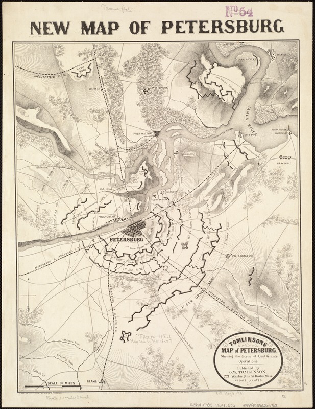
Tomlinsons map of Petersburg : showing the scene of Genl. Grants operations
Item Information
- Title:
- Tomlinsons map of Petersburg : showing the scene of Genl. Grants operations
- Title at head of map :
- Map of Petersburg
- Title (alt.) :
- New map of Petersburg
- Description:
-
Torn in Two: In addition to newspaper maps, commercially published battle maps were available to folks on the home front for following the progress of the war. A number of such maps were published by Boston firms. For example, Boston publisher G.W. Tomlinson issued a map of Petersburg, Virginia, near the end of the war. Using a concentric ring overlay, it depicted the Union siege under the command of Gen. Ulysses S. Grant, of this vital railroad center approximately 20 miles south of Richmond. The map clearly delineated the elaborate trench network that both sides constructed during the campaign. The assault began in June 1864 and lasted for ten months, the longest sustained operation of the war.
- Creator:
- Stoecklein, Charles.
- Name on Item:
-
eng. by Charles Stoecklein.
- Date:
-
1864
- Format:
-
Maps/Atlases
- Location:
-
Boston Public Library
Norman B. Leventhal Map & Education Center - Collection (local):
-
Norman B. Leventhal Map & Education Center Collection
- Subjects:
-
Petersburg (Va.)--History--19th century--Maps
United States--History--Civil War, 1861-1865--Campaigns--Maps
Grant, U. S. (Ulysses S.), 1881-1968
- Places:
-
VirginiaPetersburg
- Extent:
- 1 map : 41 x 34 cm.
- Terms of Use:
-
No known copyright restrictions.
No known restrictions on use.
- Publisher:
-
Boston :
G. W. Tomlinson
- Scale:
-
Scale [ca.1:76,000].
- Language:
-
English
- Notes:
-
Shows radial distances to Petersburg from surrounding areas, names of roads, rail roads, drainage, towns, and fortifications for Union and Confederate armies.
Relief shown by hachures.
Below lower margin: Entered according to Act of Congress in the year 1864 by G. W. Tomlinson, in the Clerks Office of the District Court of Mass.
- Notes (exhibitions):
-
Exhibited: "Torn in Two: The 150th Anniversary of the Civil War" organized by the Norman B. Leventhal Map Center at the Boston Public Library, 2011.
- Identifier:
-
06_01_006552
- Call #:
-
G3884.P4S5 1864 .S76
- Barcode:
-
39999059026490