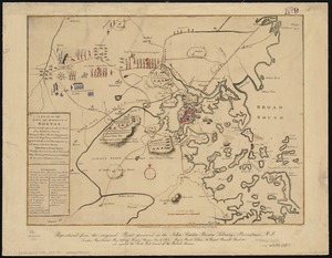
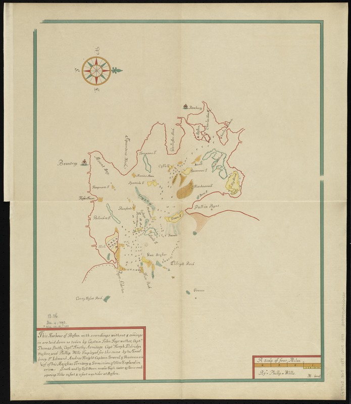
This harbour of Boston
Item Information
- Title:
- This harbour of Boston
- Title (alt.):
-
Harbour of Boston
Fac-simile of the earliest known chart of Boston Harbor
Chart of Boston Harbor
- Creator:
- Wells, Phillip.
- Name on Item:
-
with soundings without & comings in are laid down as taken by Captain John Fayrwether, Captn. Thomas Smith, Captn. Timothy Armitage, Captn. Joseph Eldridge Masters, and Phillip Wells, imployed for the same by His Excellency Sr. Edmund Andros Knight, Captain General and Governour in Chief of his Majesties Territory & Dominion of New England in [Am]erica.
- Date:
-
[1893?]
- Format:
-
Maps/Atlases
- Location:
-
Boston Public Library
Norman B. Leventhal Map & Education Center - Collection (local):
-
Norman B. Leventhal Map & Education Center Collection
- Subjects:
-
Boston Harbor (Mass.)--Maps--Early works to 1800--Facsimiles
- Places:
-
MassachusettsBoston Harbor
- Extent:
- 1 map : color ; 55 x 43 cm + 1 page (29 cm)
- Terms of Use:
-
No known copyright restrictions.
No known restrictions on use.
- Publisher:
-
[Boston] :
[Massachusetts Historical Society]
- Scale:
-
Scale approximately 1:63,360
- Language:
-
English
- Notes:
-
Facsimile of the original at the Library of the City of Boston.
Depth shown by soundings.
Oriented with north towards the upper right.
Accompanied by note by Abner C. Goodell Jr., given in advance of its publication in the Proceedings of the Massachusetts Historical Society.
Original version: [1688?].
- Identifier:
-
06_01_009968
- Call #:
-
G3762.B65 1688 .W45 1893
- Barcode:
-
39999065666420