This map of South America, according to the newest and most exact observations
Item Information
- Title:
- This map of South America, according to the newest and most exact observations
- Title (alt.):
-
Map of South America according to the newest and most exact observations
- Creator:
- Moll, Herman, d. 1732
- Name on Item:
-
is most humbly dedicated by your Lordship's most humble servant Herman Moll, geographer ; B. Lens, delin. ; G. Vertue, sculp.
- Date:
-
[1709?–1720?]
- Format:
-
Maps/Atlases
- Location:
-
Boston Public Library
Norman B. Leventhal Map & Education Center - Collection (local):
-
Norman B. Leventhal Map & Education Center Collection
- Subjects:
-
South America--Maps--Early works to 1800
- Places:
-
South America
South America
- Extent:
- 1 map : col. ; 57 x 96 cm.
- Terms of Use:
-
No known copyright restrictions.
No known restrictions on use.
- Publisher:
-
London :
Printed for H. Moll ... I. Bowles ...
- Scale:
-
Scale [ca. 1:17,500,000].
- Language:
-
English
- Table of Contents:
-
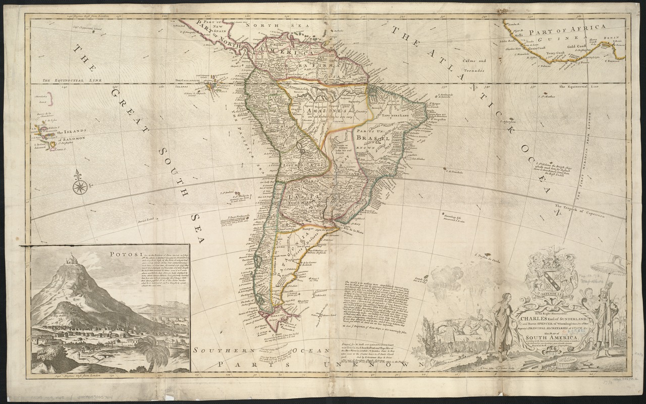
Inset: Potosi (includes view and text).
- Notes:
-
Cartouche title.
Map of South America showing the boundaries in colour between different countries and regions. It includes annotations for land features such as capes, rivers and ports, cities and towns. Relief is shown for mountainous areas pictorially but with no indication of height. Pictures include Potosi, a port town along the Peruvian coast, and around the title cartouche are images of Indians, precious metals and erupting volcanoes.
Hand colored.
Imprint on map: Printed for H. Moll over against Devereux Court near Temple Bar ; I. Bowles, Print. and Map Seller at the Black Horse in Cornhill ; T. Bowles, Print and Map Seller next to the Chapter house in St. Paul's Church yard ; and P. Overton, Map & Print seller rear St. Dunstan's Church, Fleetstreet ; and by John King, Print & Map Seller at the Globe in the Poultry.
Dedication on cartouche: To the Right Honourable, Charles, Earl of Sunderland, and Baron Spencer of Wormleighton; one of Her Majesty's principal Secretaries of State; &c.
At bottom center of map: text of note by Moll giving a diatribe on the inaccuracies of other mapmakers, presumed to be John Senex, his English competition.
Prime meridian: London.
Plate 11 from: The world described, or, a new and correct sett of maps / Herman Moll. [London] : J. Bowles, [1720?].
At top of map: Degrees east from London.
At bottom of map: Degrees west from London.
Cataloging, conservation, and digitization made possible in part by The National Endowment for the Humanities: Exploring the human endeavor.
- Identifier:
-
06_01_006443
- Call #:
-
G5200 1709 .M65
- Barcode:
-
39999059025724


