Toggle navigation
LMEC Home
Exhibitions
Georeferencing
Tools for Teachers
Collections
My Favorites
Sign Up / Log In
Search
Search the map portal
Map Collection
Map Collection
Map Sets
Search
Search
Search for
Search In
All Fields
Creator
Title
Subject
Place
Search All Digital Collections
Advanced Search
248 Results
My Search
Start Over
Date
1845
to
1849
Remove constraint Date: <span class='from'>1845</span> to <span class='to'>1849</span>
Filter your Search
Place
North and Central America
137
United States
114
Massachusetts
53
Europe
43
Oceania
32
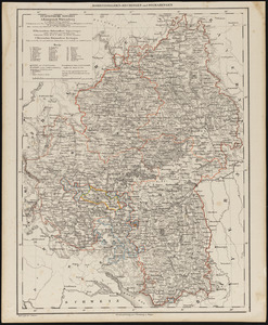
Suffolk (county)
22
Boston
20
New England
16
more
Place
»
Topic
United States Exploring Expedition (1838-1842)
16
New England--Maps
12
Boston (Mass.)--Maps
10
Massachusetts--Maps
10
Railroads--New England--Maps
10
United States--Maps
10
Railroads--Massachusetts--Maps
8
Railroads--New York (State)--Maps
7
more
Topic
»
Date
1845
to
1849
[remove]
248
Date range begin
–
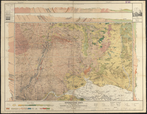
Date range end
Current results range from
1770
to
1990
1845
to
1845
111
1846
to
1846
119
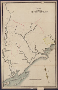
1847
to
1847
114
1848
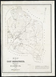
to
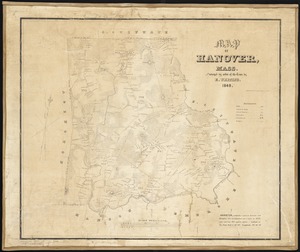
1848
116
1849
to
1849
138
Creator
United States Exploring Expedition (1838-1842)
34
Wilkes, Charles, 1798-1877
31
Sherman & Smith
19
J. & C. Walker (Firm)
10
Great Britain. Hydrographic Office
7
Vidal, A. T. E. (Alexander Thomas Emeric), 1792-1863
7
Horsburgh, James
5
Wadsworth, Alexander, 1806-1898
5
more
Creator
»
Format
Maps/Atlases
244
Manuscripts
14
Prints
3
Books
1
Georeferenced
Yes
32
No
216
Collection
Norman B. Leventhal Map & Education Center Collection
221
Boston and New England Maps
62
Maritime Charts and Atlases
52
Urban Maps
50
American Revolutionary War-Era Maps
13
Library of Congress Collection
5
Robert E. Diefenbach Map Collection at Phillips Academy
5
Lucius Beebe Memorial Library Historic Maps
4
more
Collection
»
Available to use
No known restrictions
227
Creative Commons license
11
Search Constraints
Sort by relevance
relevance
title
date (asc)
date (desc)
Number of results to display per page
100 per page
10
per page
20
per page
50
per page
100
per page
View results as:
grid view
map view
Search Results
1.
1. Prise de Newport par d'Estaing, 1778 : 2. Embossage de Ternay à Newport, 1780
2.
Afrika
3.
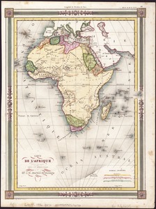
Afrique
4.
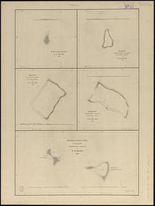
Ahii and Manhii or Peacock and Wilsons Islands
5.
Alden's pictorial map of the United States of North America
6.
America : Nach Arrowsmith, Brué und Lapie mit Benutzung der neuesten Vermessungen
7.
America settle
8.
Ansei kaisei Oedo ōezu = Map of Jeddo
9.
Antilles ou Indes Occidentales
10.
Apolima, Samoan Group ; Harbour of Oafonu, Isld. of Tutuila, north side ; Harbour of Aur, Isld. of Tutuila, north side ;...
11.
Athens
12.
Atlantic Ocean, Azores or Western Isles
13.
Azores, Corvo and Flores
14.
Azores, Fayal Pico and San Jorge
15.
Azores, San Miguel
16.
Azores, Santa Maria and the Formigas
17.
Azores, Terceira and Graciosa
18.
Battle of Cerro Gordo, April 17th & 18th 1847
19.
Battles of Mexico : survey of the line of operations of the U.S. Army, under command of Major General Winfield Scott, on the...
20.
Bay of Massefao, island of Tutuila ; Bay of Fagaitui, island of Tutuila ; Sketch of Aluau Bay, 1839 ; Sketch of Anuu Island, 1839
21.
Boston Harbour : from the survey of A.S. Wadsworth, Esq., U.S.N. and the chart of Des Barres
22.
Bradshaw's plan of Paris, and map of the environs
23.
Carl Jügel's post u. reise karte von Deutschland und den nachbar staaten, bis London, Paris, Montpellier, Florenz, Warschau,...
24.
Carta geografica general de la republica Mexicana
25.
Carta statistica e postale dell'Italia
26.
Carte de l'Afrique
27.
Carte de l'Amérique Septentrionale
28.
Carte itinéraire de l'Europe indiquant les limites actuelles des etats : dédiée au Roi
29.
Channel on the north side of Vanua Levu from Aramula Passage to Muthuata Island, Feejee Islands
30.
A chart exhibiting the normal course & velocity of the tidal current at ebb in Boston Harbor
31.
Chart of Long Pond ; Chart of Spot Pond
32.
Chart of the coast of China, from the Canton River, to the Yang Tze Keang
33.
A chart of the gulf stream
34.
Chart of the Viti Group or Feejee Islands
35.
China : sheet IV south coast from Chauan Bay to Port Matheson including the Pescadore Islands
36.
China : sheet V eastern coast from Port Matheson to Ragged Point
37.
China : sheet VIII eastern coast Hieshan Isles to the Yang-Tse-Kiang including the Chusan Islands
38.
Coast of North America from Point Judith to St. Antonio, (island of Cuba) including the Bahama Banks
39.
Colombie et Guyanes
40.
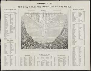
Comparative view of the principal rivers and mountains of the world
41.
Copies of plans of various parts of Brookline and Roxbury
42.
A correct map of the seat of war in Mexico : being a copy of Genl. Arista's map, taken at Resaca de la Palma, with additions...
43.
Deans, Krusensterns, and Lazareff Islands
44.
Deutschland, königr. der Niederlande, kgr. Belgien und die Schweiz, nebst theilen der angränzenden länder nach Adolf...
45.
Diagram of rail roads diverging from Boston : showing the depots and distances
46.
Disappointment Group ; Serle Island ; Clermont-Tonnere
47.
Dongguk yojido
48.
Eastern passages to China
49.
Eastern passages to China
50.
Eisen-bahn-karte von Deutschland und den angrenzenden ländern : zugleich als übersicht aller wichtigsten land- und...
51.
An exact plan of the sea coast of the continent from Paucatuck River eastwards to Point Judith and from thence northwards to...
52.
Extract from the plan of the coast survey of Boston Harbor, 1847
53.
Fakaafo or Bowditch Island ; Nuku-Nono or Duke of Clarence Island ; Oatáfu or Duke of York Island
54.
Fangaloa Bay, north side of Upolu
55.
Fayal Id., Horta and Pim Bays ; Azores, Fayal Channel
56.
Funafuti or Ellices Island ; Nukufetau or De Peysters Island ; De Peysters Group
57.
Galignani's plan of Paris and environs
58.
The game of American story and glory : [cards]
59.
Geognostische karte der umgebungen von Krems und vom Manhardsberge : jm flächenraume von 34 quadrat meilen
60.
Geographisches lottospiel, ganz neue vermehrte u. verbesserte auflage : durch welches sich die kinder spielend neit den...
61.
Geological map of part of Jamaica
62.
Haejwa do
63.
The harbor of Holmes' Hole
64.
Harbour of Mataatu, north side, island of Savaii ; Harbour of Apia, north side, island of Upolu ; roadstead between Laulii and...
65.
Harbour of Pago Pago, island of Tutuila
66.
Harbour of Sanaapu, island of Upolu ; Harbour of Falifa, island of Upolu
67.
Harbour of Uafato, island of Upolu ; Harbour of Saluafata, island of Upolu
68.
Harbours of Papieti, Toanoa, Papaoa and Matavai Bay, with the ship channel through reef, island of Tahiti
69.
Hohenzollern-Hechingen und Sigmaringen
70.
Hudsons Island ; Maraki or Matthews Island, Kingsmill Group ; Maiana or Halls Island, Kingsmill Group ; Apamama or Hoppers...
71.
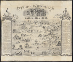
The hymenial expositor, or, matrimonial chart
72.
Illustrations of Charlecote Hall, Church of the Holy Trinity, and New Place
73.
Illustrations of Shakespeare's house and school
74.
Island and harbours of Mbenga, south side of Viti Levu, Feejee Group ; Rewa-Roads, south side of Viti Levu
75.
Island of Moala, Feejee Group ; Island of Totoia, Feejee Group ; Island of Matuku, Feejee Group
76.
Island of Ovolau, Feejee Group
77.
Island of Savaii, Samoan Group
78.
Island of Upolu, Samoan Group
79.
Island of Yendua, Feejee Group ; Nucumurry Harbour, west end of Vanua Levu ; Wailea Bay, north side of Vanua Levu
80.
Islands of Manua, Ofoo & Oloosinga, Samoan Group ; Island of Tutuila, Samoan Group
81.
[Isthmus of Tehuantepec, Mexico]
82.
Joseon yojido
83.
Kawahe or Vincennes Island, Paumoto Group ; Raraka Island, Paumotu Group
84.
King Georges Group ; Aratica or Carlshoff Island
85.
Lewis' free soil, slavery, and territorial map of the United States
86.
Liverpool
87.
Location of the Boston & Maine extension rail road : from Boston to Wilmington
88.
[Manuscript map of coast from Maine to Delaware]
89.
Manuscript map of the United States
90.
Manuscript maps of U.S. states, possibly drawn by a schoolchild
91.
Map & profiles of the Vt. Central and Vt. and Canada Railroads
92.
Map exhibiting the rail road, canal, lake and river routes from New York and Boston to the west, via Ogdensburgh, Buffalo and...
93.
Map exhibiting the rail road routes leading from Boston, to Ogdensburg and Buffalo, N.Y
94.
Map of a part of west-Florida : overlay down
95.
Map of a part of west-Florida : overlay up
96.
Map of a tour from Independence to Santa Fé, Chihuahua, Monterey and Matamoros
97.
Map of a woman's heart
98.
Map of an exploring expedition to the Rocky Mountains in the year 1842 and to Oregon & north California in the years 1843-44
99.
Map of East Bridgewater, Mass
100.
Map of Hanover, Mass
‹ Prev
Next ›
1
2
3


![[Isthmus of Tehuantepec, Mexico]](https://bpldcassets.blob.core.windows.net/derivatives/images/commonwealth:4m90fj46g/image_thumbnail_300.jpg)


![[Manuscript map of coast from Maine to Delaware]](https://bpldcassets.blob.core.windows.net/derivatives/images/commonwealth:x633f976h/image_thumbnail_300.jpg)