Comparative view of the principal rivers and mountains of the world
Item Information
- Title:
- Comparative view of the principal rivers and mountains of the world
- Date:
-
[1840–1849]
- Format:
-
Maps/Atlases
- Location:
-
Boston Public Library
Norman B. Leventhal Map & Education Center - Collection (local):
-
Norman B. Leventhal Map & Education Center Collection
- Subjects:
-
Mountains--Charts, diagrams, etc.
Mountains--Pictorial works
Rivers--Pictorial works
Rivers--Charts, diagrams, etc.
Balloon ascensions--Charts, diagrams, etc.
- Extent:
- 1 map ; 23 x 28 cm, on sheet 43 x 55 cm
- Terms of Use:
-
No known copyright restrictions.
No known restrictions on use.
- Publisher:
-
[Place of publication not identified] :
[publisher not identified]
- Language:
-
English
- Notes:
-
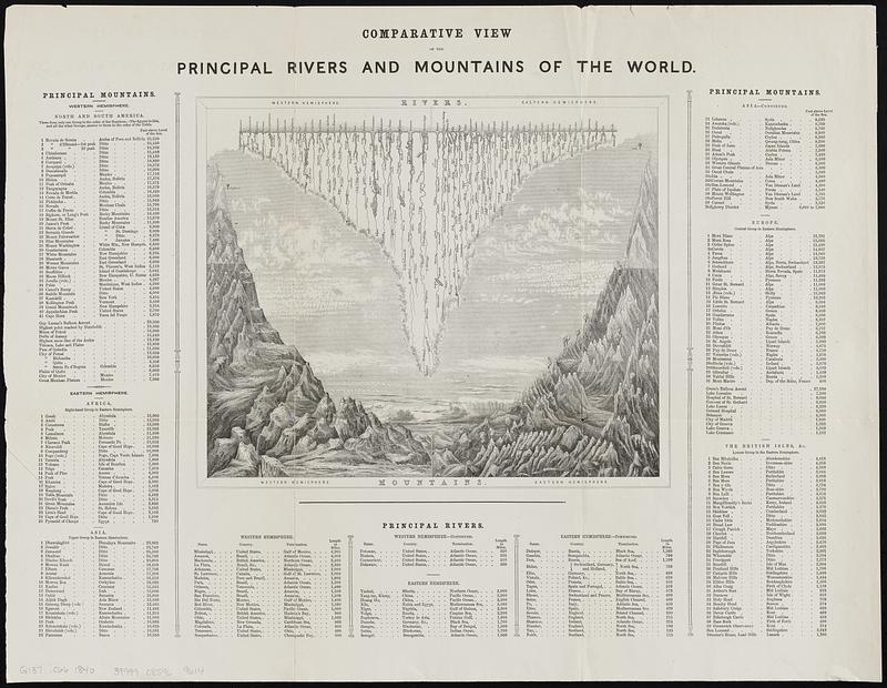
Diagram illustrating mountain heights, heights of balloon ascents by Gay Lusac and Green, and river lengths.
Includes lists of mountains with location and height by continent; lists of rivers with location and length by hemisphere; and heights of ascents, cities, and other geographic features.
- Notes (date):
-
This date is inferred.
- Identifier:
-
06_01_018786
- Call #:
-
G137 .C66 1840
- Barcode:
-
39999085969614


