Ansei kaisei Oedo ōezu = Map of Jeddo
Item Information
- Title:
- Ansei kaisei Oedo ōezu = Map of Jeddo
- Title (alt.):
-
Oedo ōezu
- Description:
-
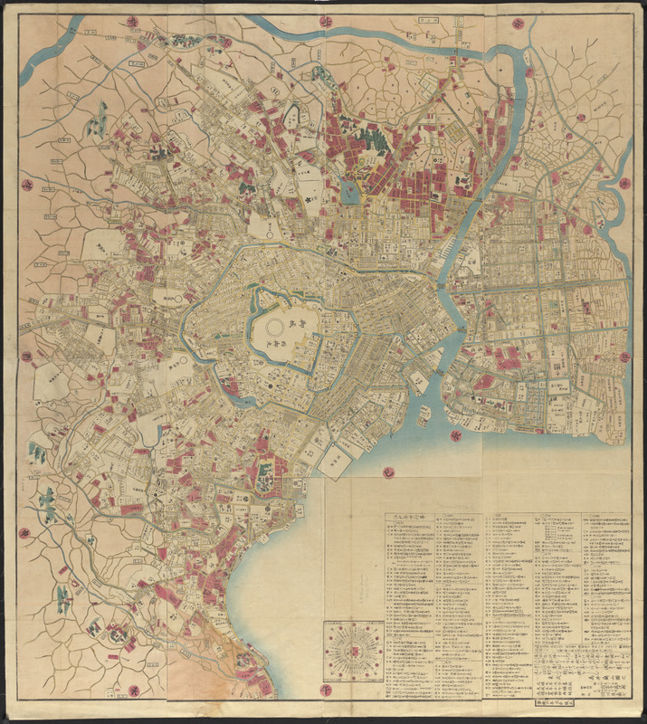
Hand-colored map of Jeddo (Edo), or Tokyo, Japan showing the Shogunate precinct and gardens, government offices, houses and grounds, temples, shrines, bays, rivers, markets, canals, roads, bridges, and fields of rice and vegetables.
- Cartographer:
- Takai, Ranzan, 1762-1838
- Name on Item:
-
Takai Ranzan
- Date:
-
1849
- Format:
-
Maps/Atlases
- Location:
-
Boston Public Library
Norman B. Leventhal Map & Education Center - Collection (local):
-
Norman B. Leventhal Map & Education Center Collection
- Subjects:
-
Real property--Japan--Tokyo--Maps
Tokyo (Japan)--Maps
- Places:
-
JapanTokyo
- Extent:
- 1 map : hand colored ; 117 x 131 cm, folded in envelope 28 x 21 cm
- Terms of Use:
-
No known copyright restrictions.
No known restrictions on use.
- Publisher:
-
[Edo] :
Izumoji Manjirō
- Scale:
-
Scale approximately 1:10,000
- Language:
-
Japanese
- Notes:
-
Cover title.
Originally published: Genroku 9 [1696], revised Bunsei 5 [1822], reprinted Tenpō 14 [1843].
Wood block print.
Relief shown pictorially.
Includes distance chart and day by day listing of events in Edo for 1859.
Key to colors printed on verso of envelope.
Accompanied by a sheet of text, titled "Map of Jeddo."
This map is all the work of native artists, and was printed and colored in the City of Jeddo, Japan for the Rev. Henry Wood, Chaplain of the steam frigate Powhatan.--Accompanying sheet.
In Japanese.
- Identifier:
-
06_01_015345
- Call #:
-
G7964.T7G46 1859 .T35
- Barcode:
-
39999085935003