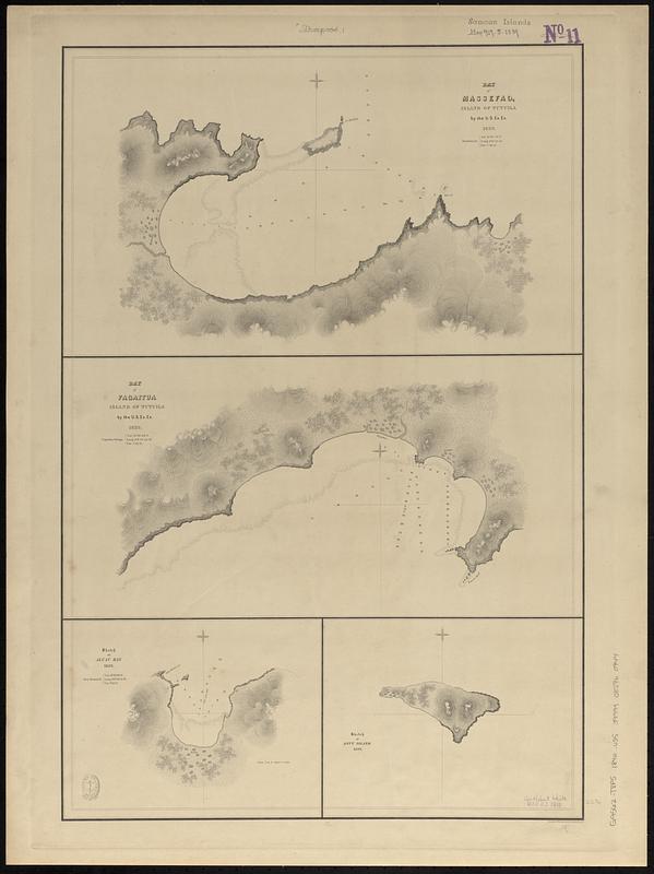
Bay of Massefao, island of Tutuila ; Bay of Fagaitui, island of Tutuila ; Sketch of Aluau Bay, 1839 ; Sketch of Anuu Island, 1839
Item Information
- Title:
- Bay of Massefao, island of Tutuila ; Bay of Fagaitui, island of Tutuila ; Sketch of Aluau Bay, 1839 ; Sketch of Anuu Island, 1839
- Surveyor:
- Wilkes, Charles, 1798-1877
- Engraver:
- Sherman & Smith
- Cartographer:
- United States Exploring Expedition (1838-1842)
- Name on Item:
-
eng. by Sherman & Smith
- Date:
-
[1840–1849]
- Format:
-
Maps/Atlases
- Genre:
-
Nautical charts
- Location:
-
Boston Public Library
Norman B. Leventhal Map & Education Center - Collection (local):
-
Norman B. Leventhal Map & Education Center Collection
- Subjects:
-
Masefau Bay (American Samoa)--Maps
Faga'itua Bay (American Samoa)--Maps
Aoloau Bay (American Samoa)--Maps
Aunuu Island (American Samoa)--Maps
Nautical charts--American Samoa--Tutuila Island
Nautical charts--American Samoa--Masefau Bay
Nautical charts--American Samoa--Faga'itua Bay
Nautical charts--American Samoa--Aoloau Bay
Nautical charts--American Samoa--Aunuu Island
United States Exploring Expedition (1838-1842)
- Places:
-
American Samoa (territory)Aunuu (island)
Masefau Bay
Faga‘itua
Aoloau Bay
- Extent:
- 4 maps on 1 sheet ; 58 x 39 cm
- Terms of Use:
-
No known copyright restrictions.
No known restrictions on use.
- Scale:
-
Scale approximately 1:12,000
Scale approximately 1:12,200
Scale approximately 1:15,000
Scale approximately 1:20,000
- Language:
-
English
- Table of Contents:
-
Harbour of Mataatu, north side, island of Savaii / U.S. Ex. Ex. 1839 & 1841
Harbour of Apia, north side, island of Upolu / U.S. Ex. Ex.1839 & 1841
Roadstead between Laulii and Latonga, north side, island of Upolu / U.S. Ex. Ex. 1839 & 1841
Harbour of Falealili, south side, island of Upolu / U.S. Ex. Ex. 1839 & 1841
- Notes:
-
Relief shown by hachures. Depths shown by soundings and pictorially.
Published in Narrative of the United States Exploring Expedition : during the years 1838, 1839, 1840, 1841, 1842.
- Notes (date):
-
This date is inferred.
- Identifier:
-
06_01_017646
- Call #:
-
G9562.T8P5 1840 .U55
- Barcode:
-
39999085960944


