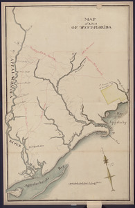
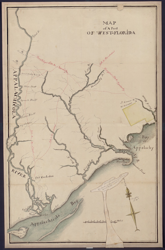
Map of a part of west-Florida : overlay down
This map is also available in American Revolutionary Geographies Online (ARGO), a collections portal especially built for material relating to the American Revolutionary War Era. Visit ARGO to learn more about this item and explore the historical geography of North America in the late eighteenth century.
Item Information
- Title:
- Map of a part of west-Florida : overlay down
- Date:
-
[1800–1899]
- Format:
-
Maps/Atlases
Manuscripts
- Location:
- Library of Congress Geography and Map Division
- Collection (local):
-
Library of Congress Collection
- Subjects:
-
Apalachicola River Region (Fla.)--Maps, Manuscript
Landowners--Florida--Apalachicola River Region--Maps
Real property--Florida--Apalachicola River Region--Maps
- Places:
-
Apalachicola (river)
- Extent:
- 1 ms. map : col. ; 84 x 54 cm.
- Terms of Use:
-
No known copyright restrictions.
This work is licensed for use under a Creative Commons Attribution Non-Commercial Share Alike License (CC BY-NC-SA).

- Scale:
-
Scale [ca. 1:158,400]
- Language:
-
English
- Catalog Record:
-
https://lccn.loc.gov/2006628343
- Notes:
-
General map of Apalachicola River region that shows buildings and householders' names and trails to Seminole Nations.
Pen-and-ink and watercolors.
Includes paper attachment with note in black ink.
Imperfect: Creased, stained, small piece missing, mounted on cloth backing.
- Notes (date):
-
This date is inferred.
- Notes (citation):
-
LC Luso-Hispanic world, 872
- Identifier:
-
lh000872bz