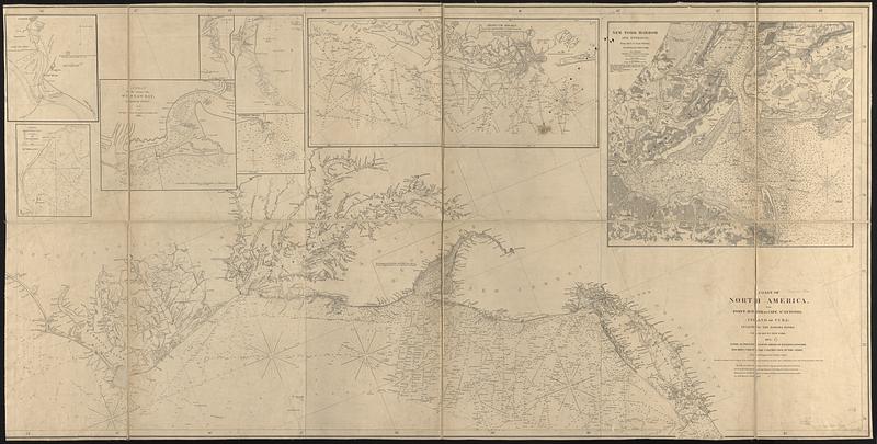
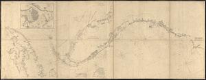
Coast of North America from Point Judith to St. Antonio, (island of Cuba) including the Bahama Banks

Item Information
- Title:
- Coast of North America from Point Judith to St. Antonio, (island of Cuba) including the Bahama Banks
- Cartographer:
- Copley, Charles
- Publisher:
- E. & G.W. Blunt (Firm)
- Name on Item:
-
drawn & engraved by Charles Copley
- Date:
-
1852
(created)
(c) 1846 (copyright)
- Format:
-
Maps/Atlases
- Genre:
-
Nautical charts
- Location:
-
Boston Public Library
Norman B. Leventhal Map & Education Center - Collection (local):
-
Norman B. Leventhal Map & Education Center Collection
- Subjects:
-
Atlantic Coast (U.S.)--Maps
Cuba--Maps
Nautical charts--Atlantic Coast (U.S.)
Nautical charts--Cuba
- Places:
-
Cuba
- Extent:
- 1 map on 7 sheets, assembled into 2 sheets, sectioned and mounted on cloth : hand colored ; 73 x 335 cm, on sheets 75 x 147 and 75 x 194 cm
- Terms of Use:
-
No known copyright restrictions.
No known restrictions on use.
- Publisher:
-
New York :
E. & G.W. Blunt
- Scale:
-
Scale approximately 1:875,000
- Language:
-
English
- Notes:
-
Relief shown by hachures. Depths shown by soundings and isolines.
Oriented with north to the upper right.
"Entered according to Act of Congress in the year, 1846, by E. & G.W. Blunt, in the Clerks office, of the District Court, of the Southern District of New York."
"Every authentic survey, American, English, & Spanish, has been used in the construction of this chart."
"Note: We are indebted to Prof. A.D. Bache Superintendent of the U.S. Coast Survey for the improvements between Cape Henlopen (including the Delaware Bay) and Montauk Point, and the offshore Soundings, which were furnished by permission of the Sec. of the Treasury. March 1847."
Includes notes and 9 insets.
Insets: New York Harbour and entrance / drawn & engraved by Charles Copley -- Absecum Shoals and the adjacent coast from the records of the U.S. Coast Survey ... 1846 -- [Cape Fear] -- [Cape Lookout] -- Hatteras Shoals, from U.S. Coast Survey, 1850 -- A plan of the entrance into Winyaw Bay, George Town, S.C. 1818 -- [Bald Head] -- Chart of Lewiston Bay exhibiting the breakwater &c. -- Plan of Havana, from the Spanish surveys.
On sheet 6: Southern coast, U. States, sheet VI, E. & G.W. Blunt, New York, 1844.
On sheet 7: Southern coast, U. States, sheet VII.
- Identifier:
-
06_01_017055A
06_01_017055B
- Call #:
-
G3302.C6P5 1852 .C67
- Barcode:
-
39999085953808