Toggle navigation
LMEC Home
Exhibitions
Georeferencing
Tools for Teachers
Collections
My Favorites
Sign Up / Log In
Search
Search the map portal
Map Collection
Map Collection
Map Sets
Search
Search
Search for
Search In
All Fields
Creator
Title
Subject
Place
Search All Digital Collections
Advanced Search
8227 Results
My Search
Start Over
More Like
commonwealth:4m90f286j
Remove constraint More Like: commonwealth:4m90f286j
Filter your Search
Place
North and Central America
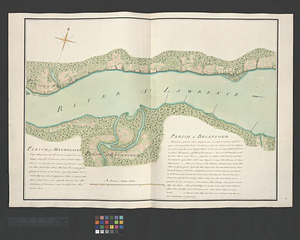
4,966
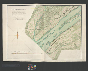
United States
3,612
Suffolk (county)
1,026
Boston
999
Europe
963
Canada
475
France
269
Massachusetts
249
more
Place
»
Topic
Boston (Mass.)--Maps
574
United States--Maps
270
Real property--Massachusetts--Boston--Maps
174
Massachusetts--Maps
160
Landowners--Massachusetts--Boston--Maps
132
North America--Maps--Early works to 1800
103
New England--Maps
101
Europe--Maps
78
more
Topic
»
Date
Date range begin
–
Date range end
Current results range from
1482
to
2023
View distribution
Creator
United States. Hydrographic Office
357
O.H. Bailey & Co
148
Des Barres, Joseph F. W. (Joseph Frederick Wallet), 1722-1824
123
United States. Post Office Dept
120
Ptolemy, 2nd cent
100
Jefferys, Thomas, -1771
96
Walling, Henry Francis, 1825-1888
94
Geological Survey (U.S.)
82
more
Creator
»
Format
Maps/Atlases
8,168
Manuscripts
216
Prints
51
Books
36
Objects/Artifacts
10
Drawings/Illustrations
8
Posters
4
Georeferenced
Yes
869
No
7,358
Collection
Norman B. Leventhal Map Center Collection
8,162
Boston and New England Maps
2,184
Urban Maps
1,925
Maritime Charts and Atlases
750
American Revolutionary War-Era Maps
681
Boston Redevelopment Authority Collection
86
William L. Clements Library Collection
43
Library and Archives Canada Collection
14
more
Collection
»
Available to use
No known restrictions
8,021
Creative Commons license
49
Search Constraints
Sort by relevance
relevance
title
date (asc)
date (desc)
Number of results to display per page
100 per page
10
per page
20
per page
50
per page
100
per page
View results as:
grid view
map view
Search Results
1.
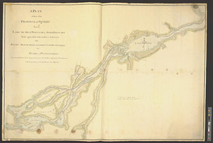
A new map of the province of Quebec, : according to the Royal proclamation, of the 7th of October 1763
2.
A new map of the province of Quebec, : according to the Royal proclamation, of the 7th of October 1763
3.
Map of Ontario and Quebec showing location and capacity of flour mills and elevators
4.
Map of the Eastern Railroad and principal connections
5.
Rand, McNally & Co.'s indexed atlas of the world map of Quebec
6.
Iroquois or St. Lawrence
7.
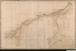
Profile of the river St. Lawrence between Montreal and Quebec shewing the deepening of the ship channel
8.
United States of America : The course of the River St. Laurence, from Lake Ontario, to Manicougan Point
9.
An Exact map of the province of Quebec with part of New York & New England from the latest surveys
10.
A new and accurate map of Quebec and its boundaries: from a late survey
11.
The provinces of New York, and New Jersey, : with part of Pensilvania [sic], and the province of Quebec
12.
Canada, Louisiane et terres angloises
13.
Canada, Louisiane et terres angloises
14.
Canada, Louisiane et terres angloises
15.
Carte du gouvernement de Montréal
16.
Channels around the Island of Orleans
17.
Continuation of the Grande Riviere with the village of Fariole lying near Cape Torment on the north shore
18.
Copie de la carte de Monsieur Klam ou l'on voit les sources e la riviere d'Orange suivant de nouvelles observation
19.
Cours du fleuve St. Laurent : deuxieme feuille : depuis Quebec jusqu'au havre des Papinachouas
20.
Cours du fleuve St. Laurent : premiere feuille : contenant depuis le Lac Ontario jusqu'a Quebec
21.
Cours du fleuve St. Laurent : troisieme feuille : depuis le mont Camille jusqu'a l'isle d'Anticosti
22.
Draught of the river St. Lawrence from Lake Ontario to Montreal
23.
Gaspee Bay
24.
Hare Island; Pointe aux Allouettes of Larks Point; English Bank
25.
Manicouagan Shoals; Havre St. Nicholas; Bay of the Seven Islands
26.
A map of part of Canada for the use of His Majesty's Secretary of State, compiled in the Surveyor Generals Office, pursuant to...
27.
Parish of Batiscant. Parish of St. Pierre Becquet. Parish of Champlain. Parish of Gentilly
28.
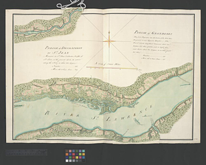
Parish of Dechaillon or St. Jean. Parish of Grondines
29.
Parish of Dechambeaux. Parish of Cape Sante. Parish of Lotbinière. Parish of St. Croix
30.
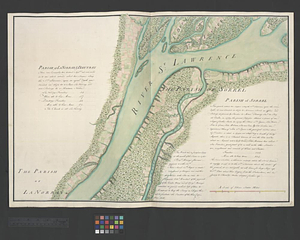
Parish of La Norray & Dautray. Parish of Sorrel
31.
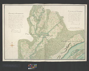
Parish of L'Assomption. Parish of St. Sulpice
32.
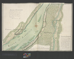
Parish of Lavalterie. Parish of Contrecoeur
33.
Parish of Magdelaine. Parish of Becancour
34.
Parish of Repentigny
35.
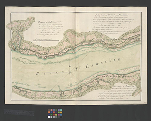
Parish of St. Ann's. Parish of the River Batiscant
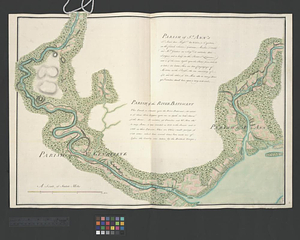
36.
Parish of St. Foix
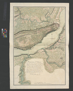
37.
Parish of St. Joachim. Parish of St. Famille. Parish of St. Anne. Parish of St. François
38.
Parish of St. Lawrence. Parish of Beaumont. Parish of St. Peter
39.
Parish of St. Michelle. Parish of St. John Baptist. Parish of St. Vertier
40.
Parish of St. Nicholas. The Parish of St. Augustin
41.
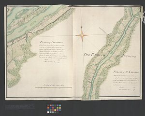
Parish of the Ecureuils. Parish of Point aux Trembles. Parish of St. Antoine. Parish of St. Croix
42.
Parish of Vercheres. Parish of St. Antoine
43.
Part of the Anticosti Island; Mingan Island; Mignan Harbor
44.
Plan of Canada or the province of Quebec from the uppermost settlements to the island of Coudre as surveyed by order of his...
45.
A plan of part of the province of Quebec from the Lake de Deux Montagne to River Batiscant made agreeable to the orders &...
46.
A plan of part of the province of Quebec from the river St. Anne to the island of Coudre made agreeable to the orders and...
47.
Plan of that part of Canada and the River St. Lawrence which lies between Point du Lac and Repentigny on the north shore &...
48.
A plan of the River St. Laurence from Green Island to Cape Carrouge
49.
A plan of the river St. Laurence, from Sillery to the fall of Montmerenci, with the operations of the siege of Quebec; under...
50.
Plan of the river St Lawrence fom the Island of Anticosta to Quebec ... from a manuscript found on board ye Alcide taken June...
51.
Plan of the river St. Lawrence from the Island of Anticosta to Quebec ... from a manuscript found on board of the Alcide taken...
52.
A plan of the settled part of Canada reduced from the large survey made in the years 1760 & 1761 by order of General Murray...
53.
Plan of the town of Quebec the capital of Canada in North America : with the bason and a part of the adjacent country shewing...
54.
Plan of the town of Quebec the capital of Canada in North America : with the bason and a part of the adjacent country shewing...
55.
Plan of the town of Quebec the capital of Canada in North America : with the bason and a part of the adjacent country shewing...
56.
Region of Gaspee Bay
57.
Region of Hare Island
58.
The River St. Lawrence from Mal Bay to the Basin of Quebec
59.
The River St. Lawrence from the Basin of Quebec to the Falls of Richeu
60.
The Seven Islands and the Bay
61.
The Shoals of Beauport; The River St. Lawrence from the Basin of Quebec to the Falls of Richeu
62.
Sketch of the river St Lawrence from Montreal to the island of St Barnaby on the south side, and the islands of Jeremy on the...
63.
Sketch of the river St Lawrence from Montreal to the island of St Barnaby on the south side, and the islands of Jeremy on the...
64.
Sketch of the river St. Lawrence from Montreal to the island St. Barnaby on the south side, and the islands of Jeremy on the...
65.
Sketch of the river St. Lawrence from Montreal to the island St. Barnaby on the south side and the islands of Jeremy on the...
66.
Sketch of the river St: Lawrence from Montreal to the island St: Barnaby on the south side, and the islands of Jeremy on the...
67.
Sketch of the seven dangerous rappids with their true channel : also the appearance the river makes at those places between...
68.
The St. Lawrence River between Trois Rivières and Grondines Parish
69.
The St. Lawrence River from the Rapids of Richelieu to Cape Torment
70.
St. Paul's Bay; Isle de Coudres; Great Cove; Pt. de Mille Vaches
71.
Town of Three Rivers
72.
The 100th anniversary map of Abraham Lincoln's visit to Massachusetts, September 11-23, 1848
73.
1630 shoreline
74.
1879. Progress map of the U.S. Geographical Surveys west of the 100th Meridian : prepared under the direction of 1st Lieut....
75.
1903 Map of Salem and surrounding places
76.
19th annual convention of the National Association of Real Estate Boards : at Tulsa, June 7 to June 11 in 1926
77.
2005 significant U.S. hurricane strikes
78.
The 2100 project : an atlas for the Green New Deal
79.
227 Harzgerode
80.
305 Glatz
81.
38,000,000 escaped -- 10,000,000 died
82.
4 Kinten
83.
660 Wakulah St., Roxbury
84.
[A chart of Boston Bay and vicinity]
85.
[A chart of New York Island & North River : East River, passage through Hell Gate, Flushing Bay, Hampstead Bay, Oyster,...
86.
The A.A.A. key road map of continental Europe
87.
Aaron Bohrod's America, its history
88.
ABC pathfinder railway guide map : eastern division
89.
Abolition of Slavery, 1863
90.
Aboriginal map of North America, denoting the boundaries and the locations of various Indian tribes
91.
Acapulco, México
92.
Accurata delineatio Castrorum Suecicorum, ut et Haffniae, Regni Daniae Metropolis
93.
Accurata delineatio oppugnatae a faederatis, Caesareis, Polonicis, Danicis, et Brandeburgicis copijs sub-ductu Seren: Electoris...
94.
Accurata delineatio regionis circa Nieburgum Fioniæ cum prælio ibi commisso inter Danorum et fæderatorum exercitum ab una et...
95.
Accurata Scaniae, Blekingiae et Hallandiae descriptio
96.
An accurate map of Cuba, and the adjacent islands
97.
An accurate map of Dorset Shire divided into hundreds
98.
An accurate map of Dorset Shire, divided into its hundreds
99.
An accurate map of England and Wales with the principal roads from the best authorities
100.
An accurate map of England and Wales with the principal roads from the best authorities
‹ Prev
Next ›
1
2
3
4
5
…
82
83


![[A chart of Boston Bay and vicinity]](https://bpldcassets.blob.core.windows.net/derivatives/images/commonwealth:cj82m2976/image_thumbnail_300.jpg)


