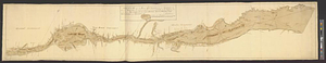
Sketch of the seven dangerous rappids with their true channel : also the appearance the river makes at those places between Fort Willm: Augustus & Lake St: Lewis

This map is also available in American Revolutionary Geographies Online (ARGO), a collections portal especially built for material relating to the American Revolutionary War Era. Visit ARGO to learn more about this item and explore the historical geography of North America in the late eighteenth century.
Item Information
- Title:
- Sketch of the seven dangerous rappids with their true channel : also the appearance the river makes at those places between Fort Willm: Augustus & Lake St: Lewis
- Date:
-
[ca. 1760]
- Format:
-
Maps/Atlases
- Genre:
-
Manuscript maps
- Location:
- William L. Clements Library
- Collection (local):
-
William L. Clements Library Collection
- Subjects:
-
Saint Lawrence River--Maps
Fort William Augustus (N.Y.)--Maps
Ontario--Maps
Québec (Province)--Maps
New York (State)--Maps
United States--History--French and Indian War, 1754-1763--Maps
- Places:
-
Saint Lawrence River
CanadaOntario (province)
CanadaQuebec (province)
New York
- Extent:
- 1 ms. map : col. ; 41.5 x 59 cm
- Terms of Use:
-
The University of Michigan Library provides access to these materials for educational and research purposes. These materials may be under copyright. If you decide to use any of these materials, you are responsible for making your own legal assessment and securing any necessary permission. If you have questions about the collection, please contact the William L. Clements Library.
Contact host institution for more information.
- Scale:
-
Scale 1:39,000.
- Language:
-
English
- Catalog Record:
-
Catalog record
- Notes:
-
The length of the river is shown in three distinct sections.
Text along bottom of map gives details on the safest way to descend the river.
- Identifier:
-
638
- Barcode:
-
B1936314