2005 significant U.S. hurricane strikes
Item Information
- Title:
- 2005 significant U.S. hurricane strikes
- Title (alt.):
-
Significant U.S. hurricane strikes
- Description:
-
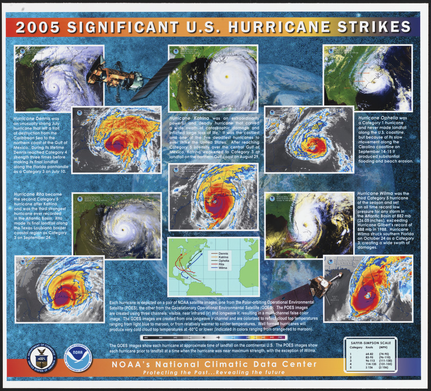
Regions and Seasons: Hurricane data collection has advanced greatly since the early 19th century, as evidenced by the development of reconnaissance aircraft, radar, satellites, and classification systems. The Saffir-Simpson Hurricane Wind Scale was created in the 1970s to categorize hurricane intensity, and has proven to be an important tool for warning the public of potential hurricane damage. The five hurricanes featured here are depicted using two types of satellite imagery, and are categorized according to the Saffir-Simpson scale. One set of images shows the rotating clouds of the hurricane, with the distinct "eye" in the center, while the other illustrates cloud top temperature, with warm blue and cold maroon.
- Creator:
- National Climatic Data Center (U.S.)
- Cartographer:
- National Climatic Data Center (U.S.)
- Creator:
- United States. National Oceanic and Atmospheric Administration
- Name on Item:
-
NOAA'S National Climatic Data Center
- Date:
-
[2005]
- Format:
-
Posters
- Location:
-
Boston Public Library
Norman B. Leventhal Map & Education Center - Collection (local):
-
Norman B. Leventhal Map & Education Center Collection
- Subjects:
-
Hurricanes--United States--Maps
United States--Maps
- Places:
-
United States
- Extent:
- 1 sheet : color, plastic-treated ; 49 x 55 cm
- Terms of Use:
-
No known copyright restrictions.
No known restrictions on use.
- Publisher:
-
[Asheville, N.C.] :
NOAA'S National Climatic Data Center
- Scale:
-
Scale not given
- Language:
-
English
- Notes:
-
10 remote-sensing images and 1 map showing hurricanes in the United States in 2005. Includes text, chart and illustrations.
- Notes (date):
-
This date is inferred.
- Notes (exhibitions):
-
Exhibited: "Regions and Seasons: Mapping Climate through History" organized by the Norman B. Leventhal Map Center at the Boston Public Library, 2017.
- Identifier:
-
06_01_015945
- Call #:
-
G3701.C86 2005 .N38
- Barcode:
-
39999085943205


