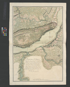
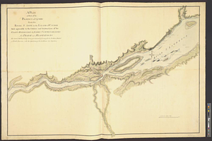
A plan of part of the province of Quebec from the river St. Anne to the island of Coudre made agreeable to the orders and instructions of the right honorable the Lords Commissioners for Trade and Plantations
This map is also available in American Revolutionary Geographies Online (ARGO), a collections portal especially built for material relating to the American Revolutionary War Era. Visit ARGO to learn more about this item and explore the historical geography of North America in the late eighteenth century.
Item Information
- Title:
- A plan of part of the province of Quebec from the river St. Anne to the island of Coudre made agreeable to the orders and instructions of the right honorable the Lords Commissioners for Trade and Plantations
- Contributor:
- Goldfrap, John George
- Creator:
- Holland, Samuel, 1728-1801
- Name on Item:
-
by Samuel Holland esqr. surveyor general of lands for the northern district of North America, with the assistance of the gentlemen his deputies
- Date:
-
[1767]
- Format:
-
Maps/Atlases
- Genre:
-
Manuscript maps
- Location:
- William L. Clements Library
- Collection (local):
-
William L. Clements Library Collection
- Subjects:
-
Saint Lawrence River--Maps
Chaudière River (Québec)--Maps
- Places:
-
Saint Lawrence River
CanadaQuebec (province)Chaudière, Rivière (river)
- Extent:
- 1 ms. map : col. ; 91 x 130cm
- Terms of Use:
-
The University of Michigan Library provides access to these materials for educational and research purposes. These materials may be under copyright. If you decide to use any of these materials, you are responsible for making your own legal assessment and securing any necessary permission. If you have questions about the collection, please contact the William L. Clements Library.
Contact host institution for more information.
- Scale:
-
Scale ca. 1:125,000.
- Language:
-
English
- Catalog Record:
-
Catalog record
- Notes:
-
Copy of original survey attributed to John George Goldfrap. See Holland to Gage, September 10, 1766.
Very detailed, finished, colored, topographical map of the St. Lawrence River on both sides of Québec showing farms, churches, roads, and vegetation.
Survey shows much of the lower Chaudière River.
- Notes (date):
-
This date is inferred.
- Identifier:
-
8238
- Barcode:
-
B1938085