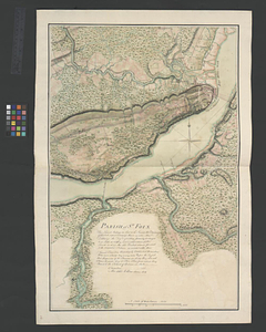
The St. Lawrence River between Trois Rivières and Grondines Parish

This map is also available in American Revolutionary Geographies Online (ARGO), a collections portal especially built for material relating to the American Revolutionary War Era. Visit ARGO to learn more about this item and explore the historical geography of North America in the late eighteenth century.
Item Information
- Title:
- The St. Lawrence River between Trois Rivières and Grondines Parish
- Title (alt.):
-
Continuation of the River Chaudière
Continuation of the River Chaudière joining to A
Continuation of the River Chaudière joining to B
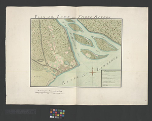
Plan of the town of Three Rivers
- Date:
-
[ca. 1761]
- Format:
-
Maps/Atlases
- Genre:
-
Manuscript maps
- Location:
- William L. Clements Library
- Collection (local):
-
William L. Clements Library Collection
- Subjects:
-
Saint Lawrence River--Maps
Chaudière River (Québec)--Maps
Trois-Rivières (Québec)--Maps
United States--History--French and Indian War, 1754-1763--Maps
- Places:
-
Saint Lawrence River
CanadaQuebec (province)Chaudière, Rivière (river)
CanadaQuebec (province)Trois-Rivières
- Extent:
- 1 ms. map : col. ; 47.5 x 69 cm.
- Terms of Use:
-
The University of Michigan Library provides access to these materials for educational and research purposes. These materials may be under copyright. If you decide to use any of these materials, you are responsible for making your own legal assessment and securing any necessary permission. If you have questions about the collection, please contact the William L. Clements Library.
Contact host institution for more information.
- Scale:
-
Scale 1:90,000. Scales of insets vary.
- Language:
-
English
- Catalog Record:
-
Catalog record
- Notes:
-
Finished, colored, topographical map showing the overall area in the St. Lawrence River depicted in 10 individually cataloged maps. The key map includes the bodies of water, islands, villages, and fortifications between Dechembaux and Pointe du Lac. The map also shows the exact extent of each map and gives the series number of each.
The key map and 10 component maps (sheets 34-43) correspond to title page sheet 32.
Included maps: Parish of Dechaillon or St. Jean. Parish of Grondines. (sheet 34) -- Parish of St. Ann's. Parish of the River Batiscant. (sheet 35) -- Parish of Batiscant. Parish of St. Pierre Becquet. Parish of Champlain. Parish of Gentilly. (sheet 36) -- Parish of Magdelaine. Parish of Becancour. (sheet 37) -- Town of Three Rivers. (sheet 38) -- Plan of the town of Three Rivers. (sheet 39) -- Continuation of the River Chaudière from where it falls into the St. Lawrence, as laid down in the lower plan, to the village of St. Marie, or Nouvelle Beausse, and of the River Etchemin as far as the village of St. Henri, with the road and communication from St. Henri to the ferry of Sartigan. (sheet 40) -- Continuation of the River Chaudière &c. (sheet 41) -- Continuation of the River Chaudière joining to A. (sheet 42) -- Continuation of the River Chaudière joining to B. (sheet 43).
Map is sheet 33 of the Murray Atlas of Canada.
- Identifier:
-
720
- Barcode:
-
B3523516