The provinces of New York, and New Jersey, : with part of Pensilvania [sic], and the province of Quebec
This map is also available in American Revolutionary Geographies Online (ARGO), a collections portal especially built for material relating to the American Revolutionary War Era. Visit ARGO to learn more about this item and explore the historical geography of North America in the late eighteenth century.
Item Information
- Title:
- The provinces of New York, and New Jersey, : with part of Pensilvania [sic], and the province of Quebec
- Description:
-
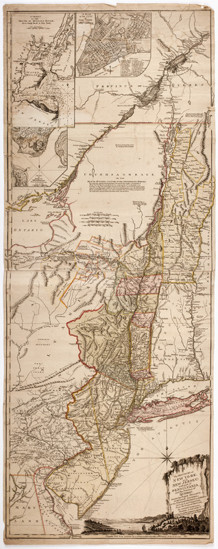
Subject: Map of New York state and New Jersey, showing their former boundary lines. Shows present day western New York as "Coughsaghrage or The beaver hunting country of the Confederate Indians." Also shows part of Quebec, New England, and the Middle Atlantic states. Cartouche at lower right shows a river scene with sailboats.
- Creator:
- Pownall, Thomas, 1722-1805
- Surveyor:
- Holland, Samuel, 1728-1801
- Publisher:
- Broenner, Harry Lodowick
- Engraver:
- Contger, Henry
- Name on Item:
-
Drawn by Major Holland, surveyor general, of the northern district in America. Corrected and improved, from the original materials, by Governr. Pownall, member of Parliament. ; Hen. Contger sculp Mog.
- Date:
-
1777
- Format:
-
Maps/Atlases
- Location:
- American Antiquarian Society
- Collection (local):
-
American Antiquarian Society Collection
- Subjects:
-
New York (State)--Maps
New Jersey--Maps
New York (N.Y.)--Maps
Hudson River (N.Y. and N.J.)--Maps
Perth Amboy (N.J.)--Maps
Québec (Province)--Maps
- Places:
-
Hudson River
CanadaQuebec (province)
New YorkNew York
New JerseyMiddlesex (county)Perth Amboy
- Extent:
- 1 map on 2 sheets : engraving, hand colored ; 133 x 52 cm., on sheets 71 x 54 cm.
- Terms of Use:
-
Public Domain/No known restrictions on use. Contact host institution to download image.
Contact host institution for more information.
- Publisher:
-
[Frankfurt] :
Published by Harry Lodowick Broenner, book-seller to Frankfort upon the Mayn.
- Scale:
-
Scale [ca. 1:660,000]
- Language:
-
English
- Catalog Record:
-
http://catalog.mwa.org/vwebv/holdingsInfo?bibId=487523
- Notes:
-
Relief shown by hachures and pictorially. Depths shown by soundings.
Insets: A plan of the city of New York. -- A chart of the mouth of Hudsons River, from Sandy Hook to New York. -- Plan of Amboy with its environs from an actual survey.
"According to an observation taken at New York by Mr. Burnet in 1723."

![[Map of parts of Pennsylvania, New York and New Jersey]](https://bpldcassets.blob.core.windows.net/derivatives/images/commonwealth:6108vt40m/image_thumbnail_300.jpg)


