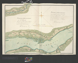
Draught of the river St. Lawrence from Lake Ontario to Montreal

This map is also available in American Revolutionary Geographies Online (ARGO), a collections portal especially built for material relating to the American Revolutionary War Era. Visit ARGO to learn more about this item and explore the historical geography of North America in the late eighteenth century.
Item Information
- Title:
- Draught of the river St. Lawrence from Lake Ontario to Montreal
- Creator:
- Davies, Thomas, approximately 1737-1812
- Date:
-
1760
- Format:
-
Maps/Atlases
- Genre:
-
Manuscript maps
Cartouches (Graphic)
- Location:
- William L. Clements Library
- Collection (local):
-
William L. Clements Library Collection
- Subjects:
-
Fort Lévis (N.Y.)--Siege, 1760--Maps
Saint Lawrence River--Maps
United States--History--French and Indian War, 1754-1763--Maps
Flags--Great Britain--Pictorial works
Indians of North America--Pictorial works
Warships--Great Britain--Pictorial works
Amherst, Jeffery Amherst, Baron, 1717-1797
Rogers, Robert, 1731-1795
- Places:
-
New YorkSaint Lawrence (county)Ogdensburg
Saint Lawrence River
- Extent:
- 1 ms. map : outline col. ; 24.7 x 231 cm
- Terms of Use:
-
The University of Michigan Library provides access to these materials for educational and research purposes. These materials may be under copyright. If you decide to use any of these materials, you are responsible for making your own legal assessment and securing any necessary permission. If you have questions about the collection, please contact the William L. Clements Library.
Contact host institution for more information.
- Scale:
-
Scale 1:126,720.
- Language:
-
English
- Catalog Record:
-
Catalog record
- Notes:
-
Finished map showing the upper St. Lawrence River.
Dotted lines indicate the routes of General Jeffery Amherst's army from Oswego to Montréal in 1760 and Robert Rogers's route from Montréal to Niagara in 1760.
Signed in second cartouche: T. Davies lt R Artillery 1760.
Shows siege batteries and bombardment of Fort Lévis in August 1760.
- Identifier:
-
560
- Barcode:
-
B1938071