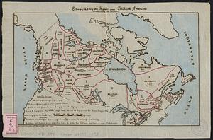
Aboriginal map of North America, denoting the boundaries and the locations of various Indian tribes

Item Information
- Title:
- Aboriginal map of North America, denoting the boundaries and the locations of various Indian tribes
- Cartographer:
- Arrowsmith, John, 1790-1873
- Printer:
- Hansard Henry, -1904
- Contributor:
- Great Britain. Parliament. House of Commons
- Date:
-
1857
- Format:
-
Maps/Atlases
- Location:
-
Boston Public Library
Norman B. Leventhal Map & Education Center - Collection (local):
-
Norman B. Leventhal Map & Education Center Collection
- Subjects:
-
Canada--Maps
United States--Maps
Indians of North America--Canada--Maps
Indians of North America--United States--Maps
- Places:
-
North America (area)
- Extent:
- 1 map : hand color ; 47 x 56 cm
- Terms of Use:
-
No known copyright restrictions.
No known restrictions on use.
- Publisher:
-
[London] :
Ordered, by the House of Commons, to be printed
- Scale:
-
Scale approximately 1:11,500,000
- Language:
-
English
- Notes:
-
Relief shown by hachures.
Shows Indian nations once dwelling east of the Mississippi.
Includes population estimates.
"Select Committee - on the Hudson's Bay Company."
"Nos. 224. 260. (Sess. 2.)."
From: Report from the Select Committee on the Hudson's Bay Company / Great Britain. Parliament. House of Commons. -- [London]: Ordered, by the House of Commons, to be Printed, 1857.
- Notes (citation):
-
Great Britain. Command Papers 224; 260
- Identifier:
-
06_01_018437
- Call #:
-
G3301.E1 1857 .A26
- Barcode:
-
39999085967493