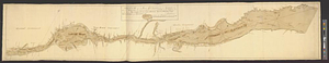
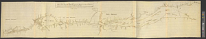
Sketch of the river St: Lawrence from Montreal to the island St: Barnaby on the south side, and the islands of Jeremy on the north side of the river
This map is also available in American Revolutionary Geographies Online (ARGO), a collections portal especially built for material relating to the American Revolutionary War Era. Visit ARGO to learn more about this item and explore the historical geography of North America in the late eighteenth century.
Item Information
- Title:
- Sketch of the river St: Lawrence from Montreal to the island St: Barnaby on the south side, and the islands of Jeremy on the north side of the river
- Date:
-
[ca. 1760]
- Format:
-
Maps/Atlases
- Genre:
-
Manuscript maps
- Location:
- William L. Clements Library
- Collection (local):
-
William L. Clements Library Collection
- Subjects:
-
Saint Lawrence River--Maps
Québec (Province)--Maps
- Places:
-
Saint Lawrence River
CanadaQuebec (province)
- Extent:
- 1 ms. map : outline col. ; 32.3 x 172 cm
- Terms of Use:
-
The University of Michigan Library provides access to these materials for educational and research purposes. These materials may be under copyright. If you decide to use any of these materials, you are responsible for making your own legal assessment and securing any necessary permission. If you have questions about the collection, please contact the William L. Clements Library.
Contact host institution for more information.
- Scale:
-
Scale of 8 leagues to one inch.
- Language:
-
English
- Catalog Record:
-
Catalog record
- Notes:
-
Signed: Jos: Allen.
Pen and ink survey of St. Lawrence River showing boundaries of Québec, Three Rivers, and Montréal governments.
For more detailed version of this map, see John Montresor's map of the same title.
- Identifier:
-
8203
- Barcode:
-
B1937642