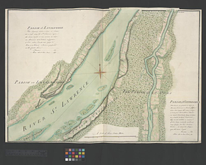
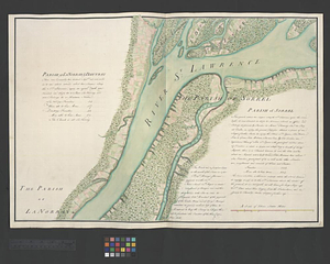
Parish of La Norray & Dautray. Parish of Sorrel
This map is also available in American Revolutionary Geographies Online (ARGO), a collections portal especially built for material relating to the American Revolutionary War Era. Visit ARGO to learn more about this item and explore the historical geography of North America in the late eighteenth century.
Item Information
- Title:
- Parish of La Norray & Dautray. Parish of Sorrel
- Date:
-
[ca. 1761]
- Format:
-
Maps/Atlases
- Genre:
-
Manuscript maps
- Location:
- William L. Clements Library
- Collection (local):
-
William L. Clements Library Collection
- Subjects:
-
Sorel (Québec)--Maps
Richelieu River (N.Y. and Vt-Québec)--Maps
Saint Lawrence River--Maps
United States--History--French and Indian War, 1754-1763--Maps
- Places:
-
CanadaQuebec (province)Sorel
Richelieu River
Saint Lawrence River
- Extent:
- 1 ms. map : col. ; 51.3 x 74 cm.
- Terms of Use:
-
The University of Michigan Library provides access to these materials for educational and research purposes. These materials may be under copyright. If you decide to use any of these materials, you are responsible for making your own legal assessment and securing any necessary permission. If you have questions about the collection, please contact the William L. Clements Library.
Contact host institution for more information.
- Scale:
-
Scale 1:24,000.
- Language:
-
English
- Catalog Record:
-
Catalog record
- Notes:
-
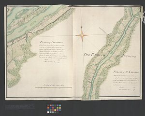
Finished, colored, topographical map showing the buildings, farms and roads of the area.
Textual information describes the history of each parish and the number of its families and the number of men able to bear arms.
Map is sheet 23 of the Murray Atlas of Canada and sheet 7 of its series.
- Identifier:
-
680
- Barcode:
-
B3521977