Toggle navigation
LMEC Home
Exhibitions
Georeferencing
Tools for Teachers
Collections
My Favorites
Sign Up / Log In
Search
Search the map portal
Map Collection
Map Collection
Map Sets
Search
Search
Search for
Search In
All Fields
Creator
Title
Subject
Place
Search All Digital Collections
Advanced Search
620 Results
My Search
Start Over
More Like
commonwealth:z603vg973
Remove constraint More Like: commonwealth:z603vg973
Filter your Search
Place
United States
415
North and Central America
321
Canada
150
Quebec
72
New York
59
North America
31
Saint Lawrence River
27
West Indies
23
more
Place
»
Topic
United States--Maps
314
United States--History--French and Indian War, 1754-1763--Maps
161
Canada--Maps
54
Elections--United States--Maps
36
Railroads--United States--Maps
34
North America--Maps
30
Saint Lawrence River--Maps
27
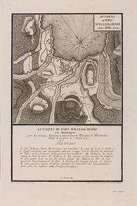
West Indies--Maps
24
more
Topic
»
Date
Date range begin
–
Date range end
Current results range from
1750
to
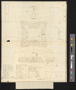
2020
View distribution
Creator
Paullin, Charles Oscar, 1868 or 1869-1944
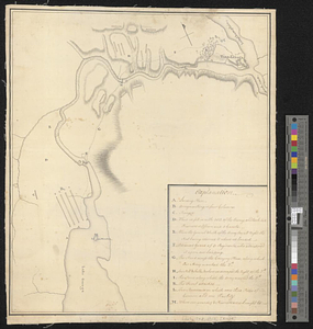
70
Wright, John Kirtland, 1891-1969
70
Rocque, Mary Ann
24
Jefferys, Thomas, -1771
18
Geological Survey (U.S.)
15
Orme, Robert, -1781
14
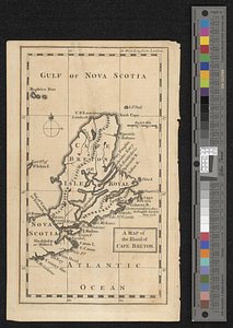
Reid, John, 1764?-1828
11
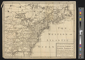
Bellin, Jacques Nicolas, 1703-1772
10
more
Creator
»
Format
Maps/Atlases
617
Manuscripts
13
Prints
3
Books
1
Objects/Artifacts
1
Posters
1
Georeferenced
Yes
77
No
543
Collection
American Revolutionary War-Era Maps
317
Norman B. Leventhal Map Center Collection
306
William L. Clements Library Collection
167
American Antiquarian Society Collection
138
Richard H. Brown Revolutionary War Map Collection at Mount Vernon
4
Boston and New England Maps
3
MacLean Collection Map Library
3
David Judkins Weaver Papers
2
more
Collection
»
Available to use
No known restrictions
233
Creative Commons license
9
Search Constraints
Sort by relevance
relevance
title
date (asc)
date (desc)
Number of results to display per page
100 per page
10
per page
20
per page
50
per page
100
per page
View results as:
grid view
map view
Search Results
1.
A New & accurate map of North America, : including the British acquisitions gain'd by the late war, 1763
2.
A Map of that part of America which was the principal seat of war in 1756
3.
America Septentrionalis : a Domino d'Anville in Galliis edita nune in Anglia Coloniss in Interiorem Virginiam deductis nec non...
4.
The British governments in Nth. America : laid down agreeable to the proclamation of Octr. 7, 1763
5.
Carte des pays connus sous le nom de Canada, : dans laquelle sont distinguées les possessions françoises, et angl?
6.
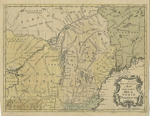
A General map of North America; : from the latest observations
7.
Karte von den seen in Canada
8.
A map of the British empire, in North America
9.
A Map of the present seat of war in North America
10.
A new map of the British empire in Nth. America
11.
Partie occidentale du Canada, : contenant les cinq Grands Lacs, avec les pays circonvoisins
12.
An accurate map of Canada, with the adjacent countries; exhibiting the late seat of war between the English & French in those...
13.
A new and accurate map of the present seat of war in North America
14.
Aboriginal map of North America, denoting the boundaries and the locations of various Indian tribes
15.
Dinsmore's complete map of the railroads & canals in the United States & Canada
16.
Dinsmore's new railroad map of the United States and the Canadas, showing all the railroads completed and in progress,...
17.
The Dominion of Canada from the latest surveys and data
18.
General railway map engraved expressly for the Official guide of the railways and steam navigation lines of the United States,...
19.
A Map exhibiting the frontiers of Canada and the United States : intended to illustrate the operations of the British &...
20.
Map of North America : showing all routes to Alaska and Klondike country
21.
Relief map of Canada and the United States
22.
Schonberg's imperial map of the United States and Canada : constructed, drawn and compiled from the latest and best authorities...
23.
Trans-continental map : showing the main lines and proposed extensions of the various trans-continental railroad systems of the...
24.
The United States of North America with the British & Spanish territories according to the treaty
25.
L'Isle de Terre-Neuve, l'Acadie, ou la Nouvelle Ecosse, : l'Isle St. Jean et la partie orientale du Canada
26.
A new and accurate map of Quebec and its boundaries: from a late survey
27.
An Accurate map of the United States of America. : According to the Treaty of Peace of 1783
28.
Amplissima regionis Mississipi : seu provinciae Ludoviciana à R.P. Ludovico Hennepin Francise Miss. in America Septentrionali...
29.
Carte de la Floride, de la Louisiane, et pays voisins. : Pour servir à l'Histoire générale des voyages
30.
A correct map of the United States of North America. : Including the British and Spanish territories, carefully laid down...
31.
A Map of the United States
32.
A new & accurate map of Louisiana, with part of Florida and Canada, : and the adjacent countries drawn from surveys assisted by...
33.
Partie de l'Amerique Septentrionale, : qui comprend le cours de l'Ohio, la Nlle. Angleterre, la Nlle. York, le New Jersey, la...
34.
The United States according to the definitive treaty of peace signed at Paris, Septr. 3d, 1783
35.
The United States of America : laid down from the best authorities agreeable to the peace of 1783. : This map and chart is...
36.
British America, comprehending Canada, Labrador, New-Foundland, Nova Scotia &c
37.
British possessions in North America
38.
The British possessions in North America from the best authorities
39.
The British possessions in North America from the best authorities
40.
Canada
41.
Canada and Nova Scotia
42.
Canada and Nova Scotia
43.
Carte de la Nouvelle-France, augmentée depuis la derniere, servant a la navigation faicte en son vray Meridien par le Sr. de...
44.
Carte du Golphe de St. Laurent et pays voisins pour servir à l'histoire générale des voyages
45.
Coal areas of Canada
46.
Dawson's map of the Dominion of Canada
47.
Dominion of Canada
48.
E.P. Dutton & Co.'s railroad, steam boat & stage route map of New England, New-York and Canada
49.
Government map of part of the Huron and Ottawa Territory, Ontario
50.
A map of Canada
51.
A map of New England, and Nova Scotia; with part of New York, Canada, and New Britain & the adjacent islands of New Found Land...
52.
Map of the Dominion of Canada
53.
A map of the province of Upper Canada, describing all the new settlements, townships, & cc. with the countries adjacent, from...
54.
Map of the provinces of upper & lower Canada with the adjacent parts of the United States of America, &c
55.
Map shewing the railways of Canada, to accompany annual report on railway statistics 1884
56.
Map showing mounted police stations in north-western Canada
57.
Map to accompany the report on the exploratory survey of the Canadian Pacific Railway
58.
Minerals
59.
A new map of Canada, also the north parts of New England and New York; with Nova Scotia and Newfound Land
60.
New map of the Dominion of Canada
61.
La Nouvelle France ou Canada
62.
Relief map of the Dominion of Canada
63.
Williams' telegraph and rail road map of the New England states, eastern protion of New York state and Canada : compiled from...
64.
Attaques des forts de Chouaguen en Amérique pris par les français commandés par le Marquis de Montcalm le 14 Août 1756
65.
Attaques des retranchemens devant le fort Carillon en Amérique par les anglais commandés par le général Abercrombie contre les...
66.
Attaques du fort William-Henri en Amérique par les troupes français aux ordres du Marquis de Montcalm prise de ce fort le 7...
67.
British attack upon Ticonderoga, July 7 & 8, 1758
68.
The Cedres
69.
Continuation of the Grande Riviere with the village of Fariole lying near Cape Torment on the north shore
70.
Continuation of the River Chaudière &c.
71.
Continuation of the River Chaudière from where it falls into the St. Lawrence, as laid down in the lower plan, to the village...
72.
Continuation of the River Chaudière joining to A
73.
Continuation of the River Chaudière joining to B
74.
A correct plan of the environs of Quebec, and of the battle fought on the 13th September, 1759 : together with a particular...
75.
A draught of a route from Québec to Fort Halifax on the River Kennebec and back again to Québec by the rivers Chaudière and...
76.
Draught of the River Pittquioyack in the Bay of Fundy 1758
77.
Draught of the river St. Lawrence from Lake Ontario to Montreal
78.
An exact ground plan of Fort Edward at Pesaquid taken from a survey and laid down by a scale of 60 feet to one inch
79.
Fort Bedford
80.
Fort Edward to Ticonderoga
81.
Fort Halifax and the Kennebec River : Québec July 25th, 1761
82.
Fort William Henry
83.
French draught of Lake Champlain & Lake George with remarks of an English prisoner who return'd from Quebec to Fort Edward by...
84.
Gabarus Bay
85.
Ein grund-ris von der Festung Duquesne ...
86.
Hudson's River from New York to Albany
87.
Lake Champlain
88.
Lake Megantic and the Chaudière River : Québec July 25th, 1761
89.
Map from Albany to Crown Point
90.
A map of the British and French settlements in North America
91.
Map of the British landings at Louisbourg
92.
A map of the country between Will's Creek & Monongahela River shewing the rout and encampments of the English army, in 1755
93.
A map of the island of Cape Breton
94.
Moosehead Lake and the immediate area to the west : Québec July 25th, 1761
95.
A new and accurate map of the English empire in North America : representing their rightful claim as confirm'd by charters, &...
96.
A new and accurate map of the English empire in North America : representing their rightful claim as confirm'd by charters, and...
97.
A new and accurate map of the present war in North America
98.
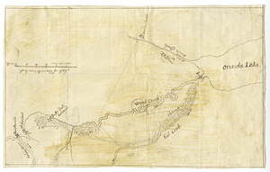
Oneida Lake to the Mohawk River
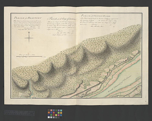
99.
Parish of Batiscant. Parish of St. Pierre Becquet. Parish of Champlain. Parish of Gentilly
100.
Parish of Beauport. Parish of L'Ange Gardien. Parish of Chateau Richer
‹ Prev
Next ›
1
2
3
4
5
6
7